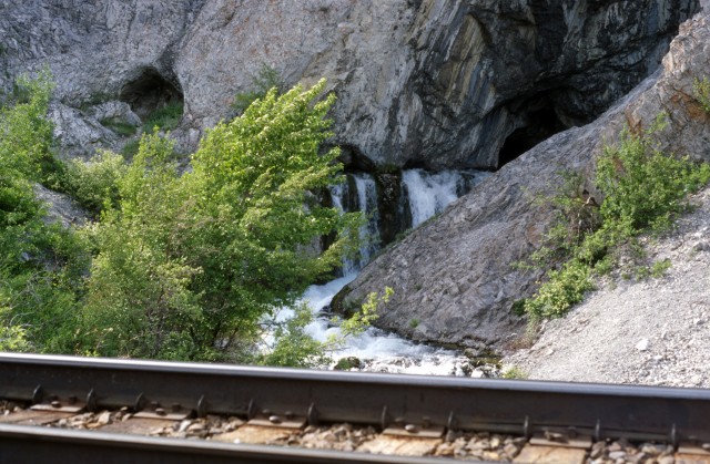
Back in 1997 I was doing some delivery work for coal mines in the Sparwood BC area, bringing various mine truck spares in from suppliers in Calgary. On one trip I took time out to explore the Crowsnest Lake Cave. You may have seen this interesting geographical feature from the highway, but you have to look hard for it. Across the lake, about mid point, just above the water you can see an opening with a stream flowing out of it, beside the train tracks at the base of a ridge.
I’ve often seen it and wondered what it would look like up close and with a bit of time to burn, I headed out. One has to follow the rail line, which in places is a narrow ledge between the ridge and lake, with little room for escape should a train arrive. You’d have to take refuge on the side of the roadbed between the tracks and the water, the deep cold water; or you’d have lay flat against rock cuts on the opposite side. Either way you’ll only have a few metres of space between you and a train. It’ll freak you out, not to mention the train crew.
↓ ↓ ↓ ↓ Scroll down for photos and to comment ↓ ↓ ↓ ↓
With that in mind, I would not suggest anyone do as I did. It’s just too dangerous! It would be safer to boat, canoe or kayak to the site, which I believe most people do.
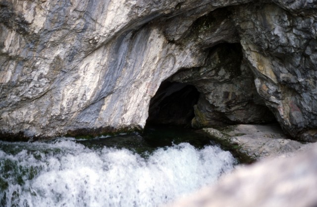
Know variously as Basin Cave, Crowsnest Lake Cave or Crowsnest Spring, it has been visited since ancient times. Inside the cave, which I could not reach due to high waters, are old pictographs, along with graffiti from more recent visitors. Water flows from several cracks, collecting in a pool, before passing under the train tracks and emptying into the lake.
The water emerging from the cave is mineral rich according to various sources and maintains a somewhat stable temperature year round. The flow volume however can be quite variable, running full out as it did on my visit, or it can be a trickle at times.
As hard as it is to believe, various crazies have cave dived here, some following the passage for quite a distance (175m in). What a dangerous sport! This author has seen the cave map and from the looks it, there is much more yet unexplored. The cave, as caves are apt to do, meanders a lot, dipping down as at fairly steady angle most of the time. There are lots of narrow side passages.
At the furthest distance explored, it’s some 60m deeper (below) the starting point, and well under the lake level. I guess the currents can be quite strong. Animal bones have been found inside.
On the far side of the ridge, to the north, is a small body of water (Phillipps Lake) with no visible outlet, which some believe is the main source of the cave’s water. I am not completely convinced however as more water flows from the cave than what the lake could supply (IMHO).
In the past, this cave was believed (by some I guess) to be the water source for the mighty Oldman River. That’s so odd, bizarre in fact, since that river’s headwaters are a fair distance away to the north, well to the north. In fact the cave’s outflow empties into the Crowsnest Lake, which then feeds the Crowsnest River. Eventually that water course does empty into the Oldman, but much further east. This author has seen a photo dated 1949, showing a large sign, proudly proclaiming “The Cave, Main Source Old Man River”. What were they smoking? Update April 18, 2020: We got it wrong. Nooooooooo! Please see the comments for an explanation. At one time the Crowsnest River was considered one arm of the Oldman.
The front ranges here are composed mainly of limestone, which can be very porous. There are numerous other caves in the area, some of them I am told, quite extensive. Connie and I have found others with small streams flowing from them, one almost directly across the valley.
One the ridge above is the Crowsnest Radio Tower, a place we’ve been up to. You may have seen the massive structure from the highway, standing guard over the lake at the pass.
Don’t forget to LIKE or SHARE this post.
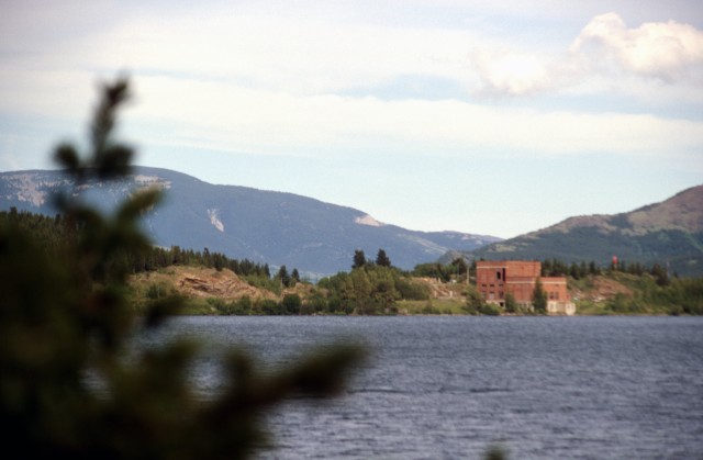
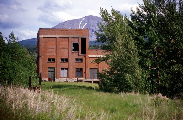
Walking the rail line – which as I said is not a good idea, even though I did it – one passes the abandoned Crowsnest Power Plant. A large brick structure, it operated from the 1920s into the late 1960s. It has sat empty ever since and we’ve visited it a couple times – getting to it too requires walking beside the rail line – watch for and listen for trains! It’s not sure what the future holds for this structure, but it has lost of historical value and hopefully will be spared.
I’d like to revisit the cave, perhaps in the fall when the water flow is less. I’d love to see those old pictographs.
Tent Mountain is not far from here and to read our reports (two of them) where we hike up to this abandoned pit mine, click the link below… Tent Mountain was torn a new one.
We have enjoyed this cave for many, many years. My dad started visiting back in the 80’s when he worked for CPR. We have always walked along the tracks, and yes you need to be very careful. You can hardly hear the train until it’s right on your ass. Train conductors are definitely not in favor of this route, but depending on weather (wind gets pretty bad) it could also be the safer route.
I’m all of my years I have never had the water be too high to access the cave, often going between mid July and mid August. You have to climb up, and then along the edge to reach cave level, you then often and have climb down a bit and back up to reach the cave. If you don’t have comfortable footing I would definitely recommend tieing yourself off to something or someone, as you may not make it out if you do fall into the fast waters.
Inside the cave. Woah. It’s beautiful, with clearly icey watering flowing. There is nice washed rock to set up your picnic and dip your toes in. The pool in the cave is fairly deep, but I would not go further than dipping toes as the rock in very slick in the water. To the right in the cave, there is a tunnel. We have no explored very far into it as we always forget a flashlight, and it gets small fairly quick. However I would love to go a little further back.
We are actually headed there next month, to pour my dads ashes. This was one of his favorite locations to visit. I will look for some photos of inside the cave
It’s been a while and we’d sure like to go back. Indeed, the CPR frowns on it and knowing what we know now we’re reluctant to take that route now. Almost thinking tagging along with someone who has a boat might be a good approach. Assuming one can even close by water – recall a steep embankment off the tracks. Either way, your comment has us longing to return. Thanks!
We were just there a few days ago. We didnt know it was there and found it by accident. Too much water to get into the cave. Gotta come back in the fall.
Cleft cave is just south of this location with a “window” on the other side that is pretty cool. Gargantua is also nearby, I haven’t done it (yet), but everything I’ve read makes it sounds even better than cleft.
That sign is long gone. I’ve seen photos of it though – I think it lasted into the latter half of the 70s. The headwaters of the Oldman are further north by a fair bit – I’ve been to them. The cave feeds the Crowsnest River, a tributary of the Oldman, which I guess is where the confusion came from.
I’m late to this discussion and you may already know this. But the Crowsnest River used to be called the Middle Fork of the Oldman River. The name was changed sometime in the 20th century. The current day Castle, Crowsnest and Oldman Rivers were collectively known as the Oldman River years ago. A great document on caves in the Crowsnest Pass area is Stephen Worthington’s Karst Hydrogeology of the Canadian Rockies.
Thank you for adding to the story. We did find that out well after the piece was published but forgot to update the post. We’ve since done that. Thanks! And we’ll search out that doc.
This is Enrico from Spain and I am so eager to visit your country. It is so beautiful and I much enjoy reading your blog. I am a cave diver and would much like to visit this cave.
Buddies and I visited the cave in the 1970s. We walked in from the quarry on the west side of the lake and I recall there were many Indian pictographs on the cave walls. It was fall and the water was barely flowing. I’ve always wanted to return!
We used to do something called the "pointless challenge" 🤪 and miss those days. It was so much silly fun and often frustrating as heck. In these we'd invite people to send in random photos of obscure locations, but not give any information, and then we'd track where it was and shoot something similar.
Most of these came from old family collections, as was the case here. Anyone up to resurrecting the series?
In hindsight, why didn't we pose someone in our shot?
Pointless: “Devoid of meaning (or) senseless” Merriam-Webster.
If you like what we do and want to support this ongoing project (12 years now), go here: https://www.BIGDoer.com/help-the-society/ Thanks to Connie for making this post possible.
Exploring history with Off the Beaten Path with Chris & Connie. Photo: ca1970 and 2014. Posted by Connie.
Captured on a cold, cold day many years ago. We've been passing this old house for decades and it's little changed in that time. At some point we expect to drive by and it'll be gone.
Exploring history with Off the Beaten Path with Chris & Connie. Photo: 2017. Posted by Connie.
When retired old railway cars usually get cut up for scrap. Sometimes, however, they find their way into the hands of the general public or whomever. Flat cars make good bridges, and boxcars can be transformed into storage buildings and the like. Case in point here. We see them used like this often enough and in this case, it's part of a corral.
Incidentally, this boxcar dates from 1950 and this was found by tracing the old road number, which is still visible.
Exploring history with Off the Beaten Path with Chris & Connie. Photo: 2017. Posted by Connie.
This central Alberta racetrack was never a commercial operation but instead just a fun place for car enthusiasts in the area to get together. Early '70s or thereabouts and it only lasted a few years. Even thought it's been abandoned for that long, there is no doubt what was here.
You know we like the the obscure stuff and this one fits the bill perfectly. Found by accident while backroad cruising and the history comes thanks to local car guy Mike.
Exploring history with Off the Beaten Path with Chris & Connie. Photo: 2022. Posted by Connie.
On top of little Myrtle Mountain in the Kimberley (BC) Nature Park.
There's some good wilderness fun to be had here and nice views as you can see, but the real reason we came is mining history. The whole area near the ski hill was extensively worked over a century ago and we were looking for evidence of this. We didn't find much in the area searched, but it's a big chunk of property and we hope to return to cover more ground again soon. Of all the subjects we cover, mining related is a favourite.
Still, it was a good hike and that can't be bad. Look to the comments for more info 👇.
Exploring nature and history with Off the Beaten Path with Chris & Connie. Photo: 2022. Posted by Connie.
It's a strange curiosity in south Kananaskis, there on a hillside and we have no idea who created it. We asked around and no one's completely sure about its history. In the past it showed the Canada 100 logo from 1967 but in 2017 someone changed it to reflect the country's 150th.
That's our friend Emily from DanOCan.com having a look.
Exploring history with Off the Beaten Path with Chris & Connie. Photo: 2017. Posted by Connie.
Javascript is required for this site to function. Please enable it in your browser settings and refresh this page.
Please log-in to continue... This allows unrestricted access to every post @BIGDoer.com, popups are eliminated, commenting is on and the "contact us" page is enabled.
Your social site may send you a routine notice of login.
Or signup, here: Subscriber Register ___ BIGDoer.com: Serving up POP HISTORY & other McFun!…(Mmmm, yummy bite-sized pieces.) One million plus words & tens of thousands of photos!


")


We have enjoyed this cave for many, many years. My dad started visiting back in the 80’s when he worked for CPR. We have always walked along the tracks, and yes you need to be very careful. You can hardly hear the train until it’s right on your ass. Train conductors are definitely not in favor of this route, but depending on weather (wind gets pretty bad) it could also be the safer route.
I’m all of my years I have never had the water be too high to access the cave, often going between mid July and mid August. You have to climb up, and then along the edge to reach cave level, you then often and have climb down a bit and back up to reach the cave. If you don’t have comfortable footing I would definitely recommend tieing yourself off to something or someone, as you may not make it out if you do fall into the fast waters.
Inside the cave.
Woah.
It’s beautiful, with clearly icey watering flowing. There is nice washed rock to set up your picnic and dip your toes in. The pool in the cave is fairly deep, but I would not go further than dipping toes as the rock in very slick in the water. To the right in the cave, there is a tunnel. We have no explored very far into it as we always forget a flashlight, and it gets small fairly quick. However I would love to go a little further back.
We are actually headed there next month, to pour my dads ashes. This was one of his favorite locations to visit. I will look for some photos of inside the cave
It’s been a while and we’d sure like to go back. Indeed, the CPR frowns on it and knowing what we know now we’re reluctant to take that route now. Almost thinking tagging along with someone who has a boat might be a good approach. Assuming one can even close by water – recall a steep embankment off the tracks. Either way, your comment has us longing to return. Thanks!
We were just there a few days ago. We didnt know it was there and found it by accident. Too much water to get into the cave. Gotta come back in the fall.
How interesting, eh! It’s always a torrent in spring, but the flow does slow down considerably later in the season.
Cleft cave is just south of this location with a “window” on the other side that is pretty cool. Gargantua is also nearby, I haven’t done it (yet), but everything I’ve read makes it sounds even better than cleft.
Awesome! We’ve done one or two caves, and lots of mines. Love being underground.
Yes got to the mouth of the Old Man River in 1972 while working for the CPR. Is the sign still there?
That sign is long gone. I’ve seen photos of it though – I think it lasted into the latter half of the 70s. The headwaters of the Oldman are further north by a fair bit – I’ve been to them. The cave feeds the Crowsnest River, a tributary of the Oldman, which I guess is where the confusion came from.
I’m late to this discussion and you may already know this. But the Crowsnest River used to be called the Middle Fork of the Oldman River. The name was changed sometime in the 20th century. The current day Castle, Crowsnest and Oldman Rivers were collectively known as the Oldman River years ago. A great document on caves in the Crowsnest Pass area is Stephen Worthington’s Karst Hydrogeology of the Canadian Rockies.
Thank you for adding to the story. We did find that out well after the piece was published but forgot to update the post. We’ve since done that. Thanks! And we’ll search out that doc.
This is Enrico from Spain and I am so eager to visit your country. It is so beautiful and I much enjoy reading your blog. I am a cave diver and would much like to visit this cave.
If you ever get the chance, be sure and visit!
Buddies and I visited the cave in the 1970s. We walked in from the quarry on the west side of the lake and I recall there were many Indian pictographs on the cave walls. It was fall and the water was barely flowing. I’ve always wanted to return!
Awesome! And I too want visit the place again.