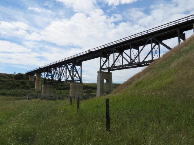
If you’ve driven highway 575 heading eastbound between Acme and Carbon, you have no doubt spotted the large train bridge spanning a deep and wide valley off to your right, at a point roughly halfway between those towns. This is the CNR’s Swalwell Bridge, a large concrete and steel structure that supports the railways north/south Alberta mainline travelling between Edmonton and Calgary.
I’ve seen the structure many times and was curious about it and this pass I decided to pay it a visit.
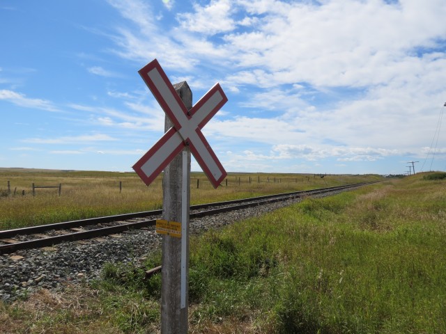
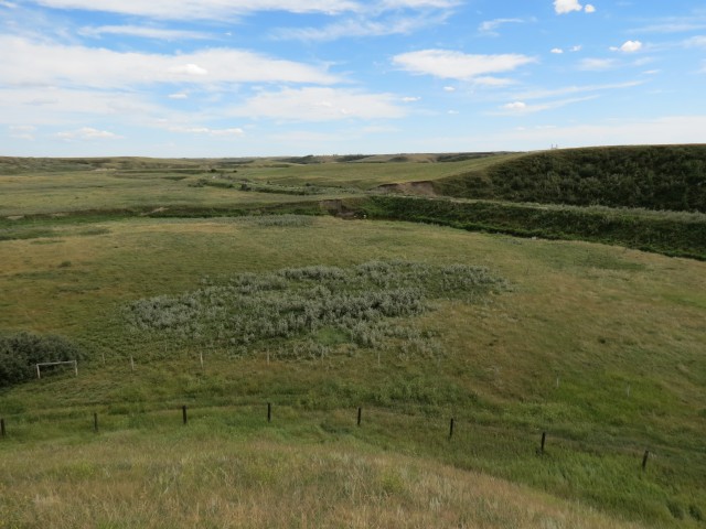
Located some distance from any roads, it would require a bit of a hike to get to. No problem, that’s what we do. Looking at Google Earth, the best approach seemed to be from the east. Parking at a spot where a rural road crosses the tracks (any time is train time) we head out and follow the fence line paralleling the rail line.
↓ ↓ ↓ ↓ Scroll down for photos or to comment ↓ ↓ ↓ ↓
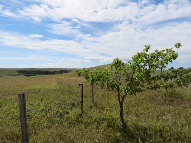
Rounding a curve, the bridge and the valley it spans, comes into view. At a lonely solitary tree (it looks like a fruit tree but bears no fruit) I jump the fence and enter a cow pasture, dropping down to creek level.
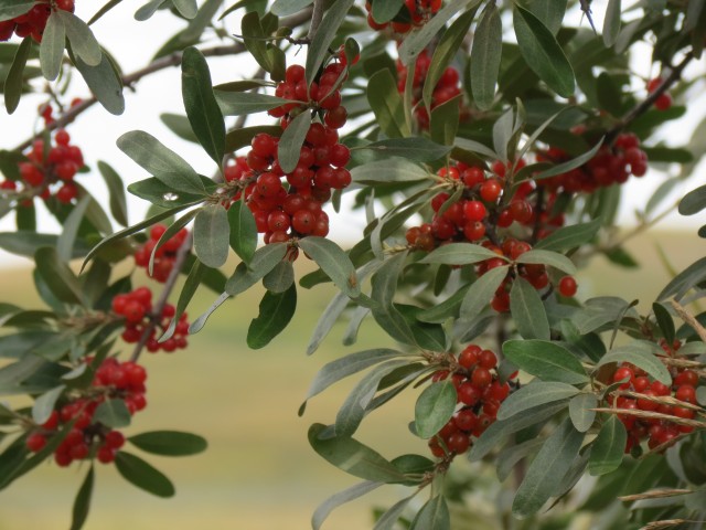
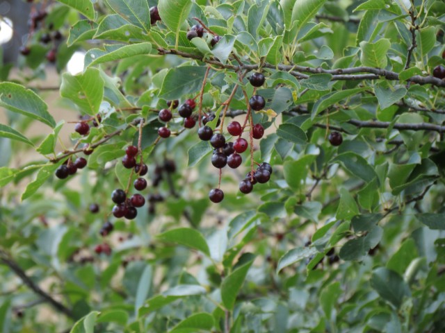
An easy animal trail takes us to our objective. Along the way I am astounded by the huge Buffalo Berry bushes (heck they are almost trees) that grow along side the path. I am familiar with the plant, the fruit is edible, and we see them all the time in the mountains. They grow much smaller there, but regardless of size, the shiny red berries tastes awful. In spite of that they are a popular food for woodland bears and were eaten by the indigenous peoples, who must have had cast iron stomachs. This year the plants bear so much fruit (no doubt due to a wet spring) that the branches seem to almost strain under the load.
Under the bridge I find more berry bushes including some Chokecherries, another edible plant. Not great tasting either, I guess with some sugar, no lots and lots of sugar, and made into a jam, the berries might be palatable. These plants grow huge here as well.
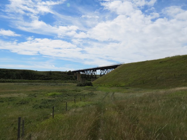
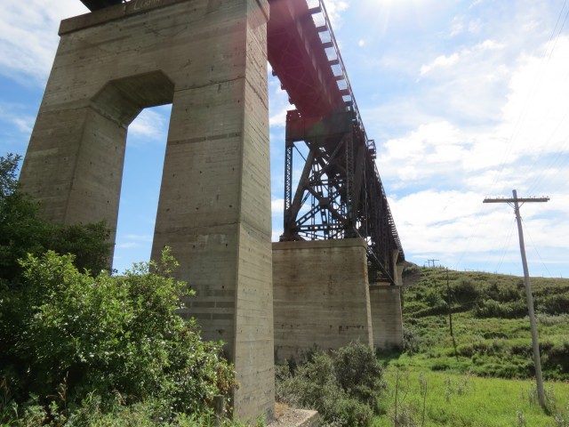
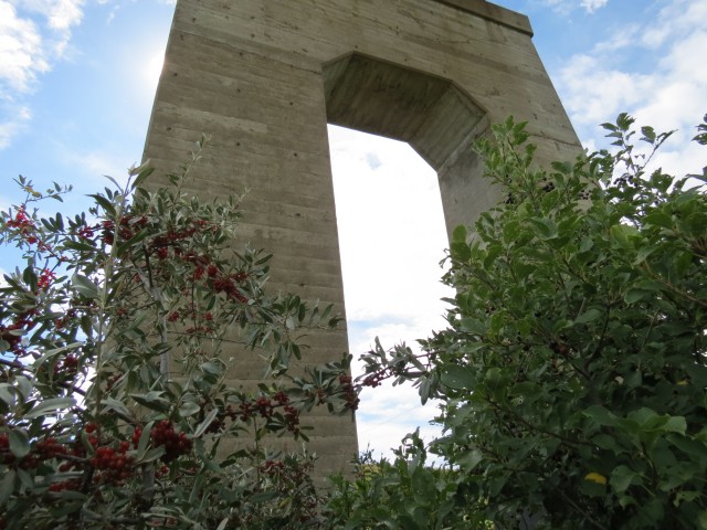
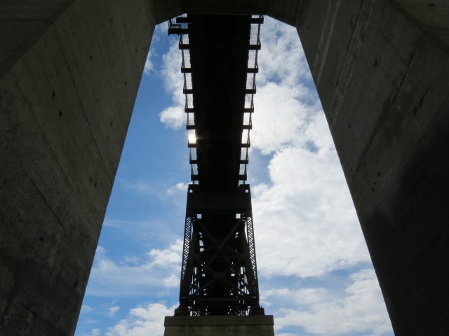
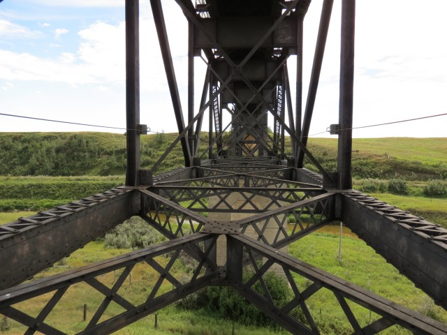
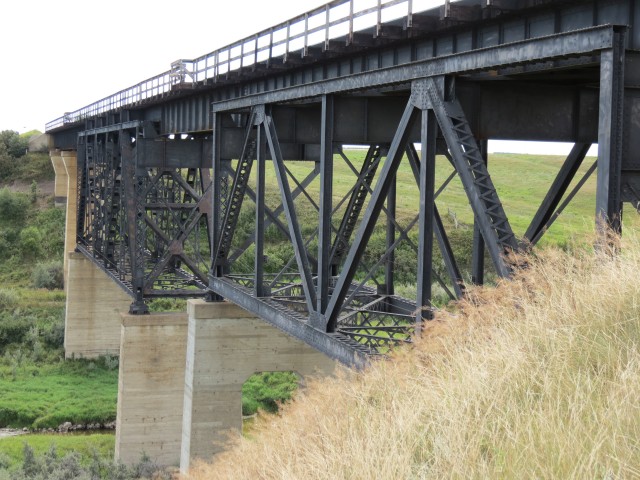
Onto our subject now and it’s massive. There are huge cement piers, supporting a combination deck truss and deck plate bridge above. It’s quite a distance from where I stand to the top.
The bridge spans the deepest section of the valley, muddy Kneehills Creek and a long abandoned CPR branch line. Prior to this structure, which was built in the mid 1950s, a huge wooden trestle used to stand here. The latter, constructed in 1913 when the railway came through here, was much longer than the current bridge. Over time the north approach was filled in with earth, resulting in the high embankment we see today.
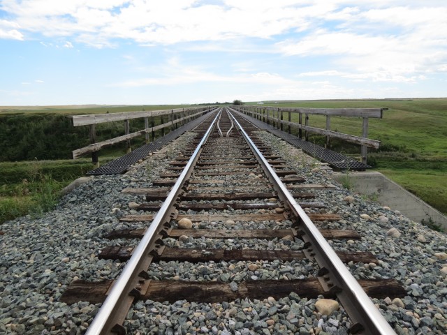
This is the CNR’s Three Hills Subdivision, originally built by the Grand Trunk Pacific. In the 1920s, that company and some others, all failing and at or near bankruptcy, were folded into the Canadian National system we know today. This line sees a couple or perhaps a few trains per day, although none showed while I explored the bridge.
Be sure to comment on this post (below pictures).
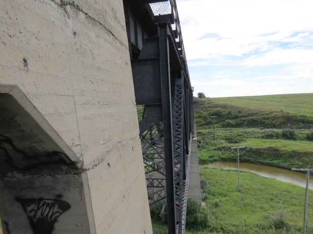
There was some graffiti on the underside of the structure which seems very odd since it’s not that easy to get here. I bet I am the first non-train visitor in a long time.
Some old telegraph poles can be seen in the area. It’s been a long time since these were used. Some still have the lines strung between them.
On the bridge’s south side is that old CPR line mentioned earlier. This was that company’s Langdon Subdivision, which travelled from it’s namesake town, to the coal fields of East Coulee. Not only a conduit for coal, lot of grain moved along the line, which came through here in 1921. The branch was abandoned in the mid 1990s and the old roadbed is still easily seen as it meanders eastbound up the valley.
We hang around hoping a train will pass – that would be a great picture – but with none come so we reluctantly head home.
Nearby is the small town of Carbon and in the past we visited it and photographed its grain elevators. To see that post, click the link below… Prairie Sentinels – Carbon Alberta.
If you’d like to know more about the subjects seen in this post, by all means contact us!
I love this article. I’ve seen that bridge many times from the highway and often wondered what it would look like from below and now I know. Walking in seemed like way too much work anyway!
Captured on a cold, cold day many years ago. We've been passing this old house for decades and it's little changed in that time. At some point we expect to drive by and it'll be gone.
Exploring history with Off the Beaten Path with Chris & Connie. Photo: 2017. Posted by Connie.
When retired old railway cars usually get cut up for scrap. Sometimes, however, they find their way into the hands of the general public or whomever. Flat cars make good bridges, and boxcars can be transformed into storage buildings and the like. Case in point here. We see them used like this often enough and in this case, it's part of a corral.
Incidentally, this boxcar dates from 1950 and this was found by tracing the old road number, which is still visible.
Exploring history with Off the Beaten Path with Chris & Connie. Photo: 2017. Posted by Connie.
This central Alberta racetrack was never a commercial operation but instead just a fun place for car enthusiasts in the area to get together. Early '70s or thereabouts and it only lasted a few years. Even thought it's been abandoned for that long, there is no doubt what was here.
You know we like the the obscure stuff and this one fits the bill perfectly. Found by accident while backroad cruising and the history comes thanks to local car guy Mike.
Exploring history with Off the Beaten Path with Chris & Connie. Photo: 2022. Posted by Connie.
On top of little Myrtle Mountain in the Kimberley (BC) Nature Park.
There's some good wilderness fun to be had here and nice views as you can see, but the real reason we came is mining history. The whole area near the ski hill was extensively worked over a century ago and we were looking for evidence of this. We didn't find much in the area searched, but it's a big chunk of property and we hope to return to cover more ground again soon. Of all the subjects we cover, mining related is a favourite.
Still, it was a good hike and that can't be bad. Look to the comments for more info 👇.
Exploring nature and history with Off the Beaten Path with Chris & Connie. Photo: 2022. Posted by Connie.
It's a strange curiosity in south Kananaskis, there on a hillside and we have no idea who created it. We asked around and no one's completely sure about its history. In the past it showed the Canada 100 logo from 1967 but in 2017 someone changed it to reflect the country's 150th.
That's our friend Emily from DanOCan.com having a look.
Exploring history with Off the Beaten Path with Chris & Connie. Photo: 2017. Posted by Connie.
April 13th 2024, the Beer Parlour Project visited the Viking Hotel, Viking Alberta and it too was an awesome time. There's Rob Pohl with his curious view camera and in the other photo Chris is seen interviewing local character Doug.
The Viking dates back to the 1930s and replaced a hotel on this same lot, which had earlier burned down.
Incidentally April 13th is also Chris and my 28th anniversary. Chris said he forgot this when scheduling this but that's fine and it doesn't matter where we celebrate but that we celebrate.
Exploring history with Off the Beaten Path with Chris & Connie. Photo: 2024. Posted by Connie.
Javascript is required for this site to function. Please enable it in your browser settings and refresh this page.
Please log-in to continue... This allows unrestricted access to every post @BIGDoer.com, popups are eliminated, commenting is on and the "contact us" page is enabled.
Your social site may send you a routine notice of login.
Or signup, here: Subscriber Register ___ BIGDoer.com: Serving up POP HISTORY & other McFun!…(Mmmm, yummy bite-sized pieces.) One million plus words & tens of thousands of photos!


")

")


I remember being at this bridge last summer, theres a rope attached to it so people can swing
Thanks for adding to the story!
I remember seeing a CPR train going under this trestle circa 1995.
One of the last I bet. I believe the line was shut down not longer after that.
This takes me back! We had a grad party under that bridge in the 1970s. We walked in from the south side, which was shorter than the way you came.
Really? And here I thought I was one of only a handful of people to have visited the site.
Never went to a party there, crossed it once though.
The view from up there from a passing train must be incredible.
I love this article. I’ve seen that bridge many times from the highway and often wondered what it would look like from below and now I know. Walking in seemed like way too much work anyway!
Let me do it for you! :>