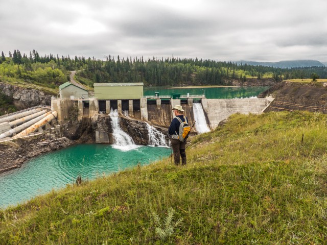
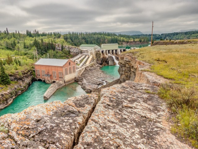
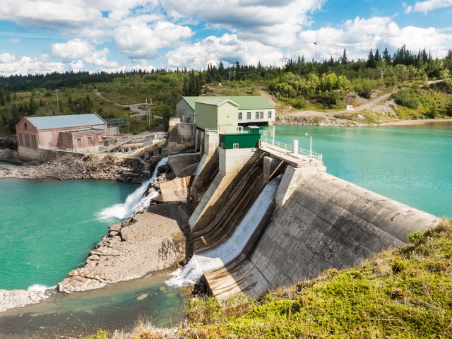
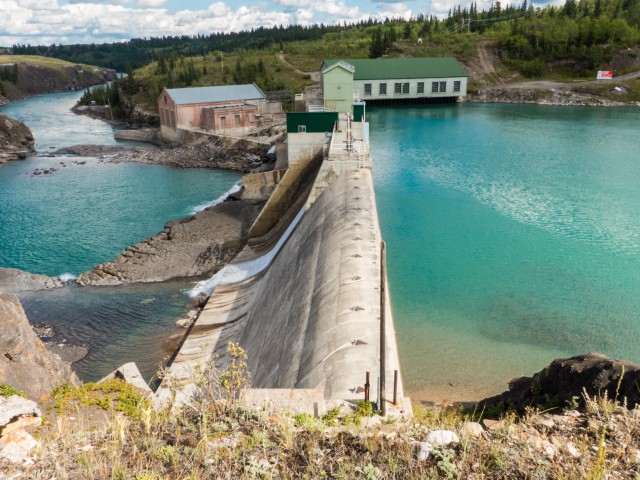
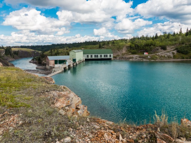
Just over century old, the Horseshoe Dam (also called the Horseshoe Falls Dam) is located along the Bow River in the foothills west of Calgary. This massive concrete structure was the very first sizable hydroelectric facility in Alberta and to this day continues to supply power for the province’s needs. Seldom seen by the general public, the only way to view it, unless of course you work there, is to hike in a fair distance along the river’s north bank.
The Bow River flows east from the mountains on its way through Calgary and points beyond. To the west of the city are four dams on this watercourse, all of which are used generate electricity. The Horseshoe Dam is the second in that chain and the oldest, having been built in 1911. Just west of it is the Seebe Dam, and downstream, the Ghost and Bearspaw Dams.
↓ ↓ ↓ ↓ Scroll down for photos and to comment ↓ ↓ ↓ ↓
The original owner of the complex was Calgary Power, who used the plant to supply the city’s growing needs along with those of some surrounding communities. Today Trans Alta Utilities runs the place and power simply goes into the grid to be sent wherever it’s needed.
The dam was built at the location of Horseshoe Falls, now under concrete and water. This author has seen photos showing the river and surrounding Horseshoe Canyon before then and it was a foaming bubbling and boiling violent stretch of water.
This dam does not require a reservoir in the traditional sense, although a small narrow lake-ish like body of water forms behind the structure. Instead, it just relies on the river’s natural flow to make power. I guess at times, usually in the winter I am told, the flow drops enough that sometimes electricity output is affected.
The Horseshoe Dam and the nearby Seebe operation are treated sort of as one big unit and for the most part are controlled remotely from far away. However, there are of course maintenance crews still on site should a problem arise.
Until about a decade ago there used to be a small town nearby, Seebe, on the south side of the river, which used to house the dam workers and their families. Now all those employed here commute in from elsewhere. Seebe was interesting in that it was the site of the last one room school in the province, which only closed in the 1990s. During World War Two, a prisoner of war camp was located not far from here.
Operationally wise, this dam like all others that produce energy, is pretty simple. Water is sent down some big pipes (called penstocks) into the generating plant where they power turbines before being ejected back into the river. Nice and easy. At times of high flow some water will bypass the turbines via control gates, one of which was open on our visit. The dam, interestingly, was partially built atop a very large rock outcropping, which was sort of incorporated into the structure.
At times of low demand both this and the Seebe Dam may not produce electricity. They have the ability to come online quickly however, should the network need more power. Even though it’s huge, by dam standards, it’s, well, rather modest in size. I am sure the structure and machinery are kept in good shape and so presumably they’ll provide power for some time to come.
I’ve often wondered how fish deal with a structure such as this. I know some dams have special fish passages, but I could not find any information is regards to that for this one.
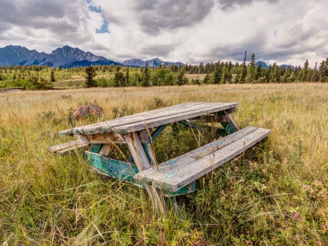
There is no public road access to the dam and to view it requires a bit of hike in. There is a little used trail, starting at the Seebe Dam (which you can also view), off highway 1A, leading to it. We actually hiked past the dam, continuing further east all the way into the Morley First Nation’s Reserve (permission is required to do this – we had it) to take in some movie locations we wanted to explore. There is a picnic table at a nice vantage point above the dam, but it’s old and falling apart.
Once at the dam, it can be viewed from many angles. It’s a long and near straight drop down to the river from the top of the canyon however, so be careful and don’t get too close to the edge. A fall from this lofty position could prove fatal.
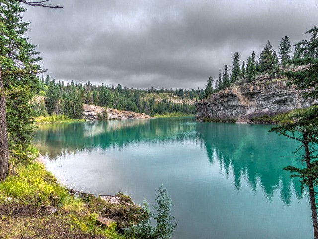
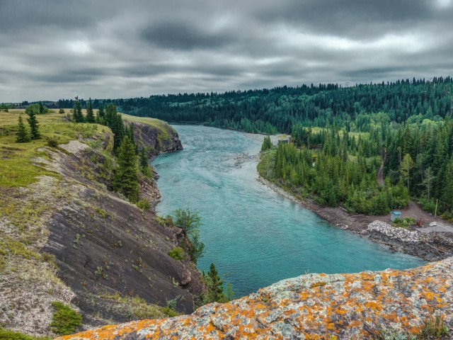
The Bow River along here are a stunning blue/green.
A good number of movies were shot just east of the dam over the years (on the off-limits Morley Reserve) including such noteworthy ones as Legends of the Fall, and the 1950s picture, starring everyone’s favourite bombshell, Marilyn Monroe, River of No Return. Most of these sites are not publicly accessible.
I was brought to this dam 45 years ago by my father. I caught my first fish there. I spent many memorable days catching and releasing fish here. It’s very unfortunate the gates are now locked. I find it very concerning that employees of the plant have made this their private fishing hole and zero access to the public. I know there is a path from the damn, however I’d be trespassing on reserve land to access it, I would never do that.
I’d guess it’s a liability thing. That’s so common today. Taking the path on the other side requires permission if proceeding past the damn, which we had. You definitely don’t want to trespass.
The property between and including Kananaskis and Horseshoe dams is not publicly owned land. The decision to fence and gate (to secure) the area was made by the owner, TransAlta Utilities – not by their employees. This action may possibly have been mandated by gov’t regulation, but most certainly would have been recommended by T.A.U.’s legal division anyway, not only to protect the power plants and other building(s) from theft/vandalism (there are no residents of Seebe there to discourage or bear witness to hostile intruders, any more), but to protect the public… yes, as liability protection!… if from nothing other than the cliff jumping that resulted so many deaths, there.
It is admirable that you would never trespass on reserve land; how can you seem so resentful that you may no longer freely trespass on someone else’s property? The now- gated property of (the late, great community known as) Seebe is not public land.
I also have cherished memories of Seebe, not the best of which were my fishing losses – rather than catching anything, I lost a few lures! – but I also lived there, and found losing our entire community pretty ‘unfortunate’, too! Perhaps we should both count ourselves lucky that we ever got to experience such memorable days in such an amazing location. (and thanks to this website for sharing images and some of the history of this area!)
Very nice post. Though it was some ago for you, I’m wondering if you would be willing to share how you obtained permission from the Reserve. I would like to walk the ridge but I would like to do so respectfully and legally. Thank you for any help you can provide me with.
So just to be sure I have this straight — you drive to Seebe, find a trail along the north bank of the river and follow it until you reach the Horseshoe Dam? Is it fairly obvious where to go? How far is the hike?
On Kananaskies public safety Facebook page there was a video earlier in the year showing the work preformed by the pubic safety team, also a view of the horseshoe dam during the flood of 2013, you can see the bow flowing over the dam, looks like a big waterfall.
We used to do something called the "pointless challenge" 🤪 and miss those days. It was so much silly fun and often frustrating as heck. In these we'd invite people to send in random photos of obscure locations, but not give any information, and then we'd track where it was and shoot something similar.
Most of these came from old family collections, as was the case here. Anyone up to resurrecting the series?
In hindsight, why didn't we pose someone in our shot?
Pointless: “Devoid of meaning (or) senseless” Merriam-Webster.
If you like what we do and want to support this ongoing project (12 years now), go here: https://www.BIGDoer.com/help-the-society/ Thanks to Connie for making this post possible.
Exploring history with Off the Beaten Path with Chris & Connie. Photo: ca1970 and 2014. Posted by Connie.
Captured on a cold, cold day many years ago. We've been passing this old house for decades and it's little changed in that time. At some point we expect to drive by and it'll be gone.
Exploring history with Off the Beaten Path with Chris & Connie. Photo: 2017. Posted by Connie.
When retired old railway cars usually get cut up for scrap. Sometimes, however, they find their way into the hands of the general public or whomever. Flat cars make good bridges, and boxcars can be transformed into storage buildings and the like. Case in point here. We see them used like this often enough and in this case, it's part of a corral.
Incidentally, this boxcar dates from 1950 and this was found by tracing the old road number, which is still visible.
Exploring history with Off the Beaten Path with Chris & Connie. Photo: 2017. Posted by Connie.
This central Alberta racetrack was never a commercial operation but instead just a fun place for car enthusiasts in the area to get together. Early '70s or thereabouts and it only lasted a few years. Even thought it's been abandoned for that long, there is no doubt what was here.
You know we like the the obscure stuff and this one fits the bill perfectly. Found by accident while backroad cruising and the history comes thanks to local car guy Mike.
Exploring history with Off the Beaten Path with Chris & Connie. Photo: 2022. Posted by Connie.
On top of little Myrtle Mountain in the Kimberley (BC) Nature Park.
There's some good wilderness fun to be had here and nice views as you can see, but the real reason we came is mining history. The whole area near the ski hill was extensively worked over a century ago and we were looking for evidence of this. We didn't find much in the area searched, but it's a big chunk of property and we hope to return to cover more ground again soon. Of all the subjects we cover, mining related is a favourite.
Still, it was a good hike and that can't be bad. Look to the comments for more info 👇.
Exploring nature and history with Off the Beaten Path with Chris & Connie. Photo: 2022. Posted by Connie.
It's a strange curiosity in south Kananaskis, there on a hillside and we have no idea who created it. We asked around and no one's completely sure about its history. In the past it showed the Canada 100 logo from 1967 but in 2017 someone changed it to reflect the country's 150th.
That's our friend Emily from DanOCan.com having a look.
Exploring history with Off the Beaten Path with Chris & Connie. Photo: 2017. Posted by Connie.
Javascript is required for this site to function. Please enable it in your browser settings and refresh this page.
Please log-in to continue... This allows unrestricted access to every post @BIGDoer.com, popups are eliminated, commenting is on and the "contact us" page is enabled.
Your social site may send you a routine notice of login.
Or signup, here: Subscriber Register ___ BIGDoer.com: Serving up POP HISTORY & other McFun!…(Mmmm, yummy bite-sized pieces.) One million plus words & tens of thousands of photos!


")


I was brought to this dam 45 years ago by my father. I caught my first fish there. I spent many memorable days catching and releasing fish here. It’s very unfortunate the gates are now locked. I find it very concerning that employees of the plant have made this their private fishing hole and zero access to the public. I know there is a path from the damn, however I’d be trespassing on reserve land to access it, I would never do that.
I’d guess it’s a liability thing. That’s so common today. Taking the path on the other side requires permission if proceeding past the damn, which we had. You definitely don’t want to trespass.
The property between and including Kananaskis and Horseshoe dams is not publicly owned land. The decision to fence and gate (to secure) the area was made by the owner, TransAlta Utilities – not by their employees. This action may possibly have been mandated by gov’t regulation, but most certainly would have been recommended by T.A.U.’s legal division anyway, not only to protect the power plants and other building(s) from theft/vandalism (there are no residents of Seebe there to discourage or bear witness to hostile intruders, any more), but to protect the public… yes, as liability protection!… if from nothing other than the cliff jumping that resulted so many deaths, there.
It is admirable that you would never trespass on reserve land; how can you seem so resentful that you may no longer freely trespass on someone else’s property? The now- gated property of (the late, great community known as) Seebe is not public land.
I also have cherished memories of Seebe, not the best of which were my fishing losses – rather than catching anything, I lost a few lures! – but I also lived there, and found losing our entire community pretty ‘unfortunate’, too! Perhaps we should both count ourselves lucky that we ever got to experience such memorable days in such an amazing location.
(and thanks to this website for sharing images and some of the history of this area!)
Sorry for the delay in responding (some health issues – nothing serious) – thanks for posting.
Very nice post. Though it was some ago for you, I’m wondering if you would be willing to share how you obtained permission from the Reserve. I would like to walk the ridge but I would like to do so respectfully and legally. Thank you for any help you can provide me with.
Glad you like it. Word on the street is they’re not allowing anyone in anymore. Sorry.
Thanks for posting this!
You are most welcome. Come back often!
Another movie shot in the area was Little Big Man.
Yes, yes, that one! Might have to find a copy to watch now…
Great photos, interesting history!
Thanks, it’s a place that so few see. Appreciate you stopping by our little corner of the world.
So just to be sure I have this straight — you drive to Seebe, find a trail along the north bank of the river and follow it until you reach the Horseshoe Dam? Is it fairly obvious where to go? How far is the hike?
Thanks for the awesome article and photos.
You’ve got it. Finding the trail is easy. It’s obvious and stays pretty close to the river the whole time. It’s perhaps 4km each way.
Do you know how they blocked out all the water while they were building the dam? They had to be no water, when they poured the concrete, right?
I don’t know specifically here, but often a temporary coffer dam was placed upstream to keep out the water, or a diversion channel of some kind built.
On Kananaskies public safety Facebook page there was a video earlier in the year showing the work preformed by the pubic safety team, also a view of the horseshoe dam during the flood of 2013, you can see the bow flowing over the dam, looks like a big waterfall.
Wow, that the dam at flood must have been a site to see.
Very beautiful!!
It’s such a nice setting.
wow! the water looks gorgeous
This stretch of water is such an amazing colour.