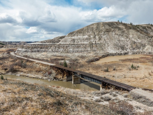
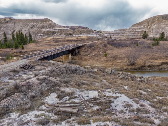
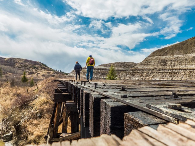
Canadian National Railway’s recently abandoned route in the Drumheller area of Alberta is home to around sixty bridges. Yes, that many, amazingly all along a stretch of line perhaps thirty or forty kilometres long (roughly). The track shares the narrow valley with the meandering Rosebud River and is forced to cross it and recross it again and again. There was no way around it. In this report we look at four of these bridges found in quick succession along a stretch if this very line.
The track that used to run here was built in the mid-1910s by the Canadian Northern Railway under the charter of the Alberta Midland Railway. It become a Canadian National Railway property in the early 1920s, when it took over operations of the CNoR (and some competing companies).
↓ ↓ ↓ ↓ Scroll down for photos or to comment ↓ ↓ ↓ ↓
The line, with many side branches, ran between Saskatoon and Calgary. It was last used for through freights around 2008 although I understand local trains continued for a short time after. The rails, by then rusty and weed choked, were only recently pulled up. All bridges remain.
This line near the end saw a few trains per day but was hindered by a lack of business along the middle section, heavy grades coming in and out of Red Deer River valley, unstable soil in the badlands and finally the bridges we’ve been speaking about. A few are no problem, but sixty (or what ever the true number is – no one seems to really know) is a costly maintenance headache.
It’s not known what officially will happen to the roadbed. Often old rail lines are converted to trails, but no solid information on what could be in store here was found. The CNR is being tight-lipped on this. We called them and they told us to bugger off.
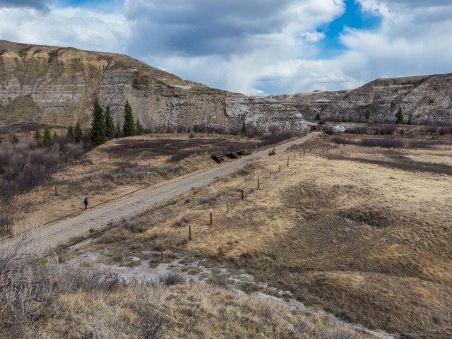
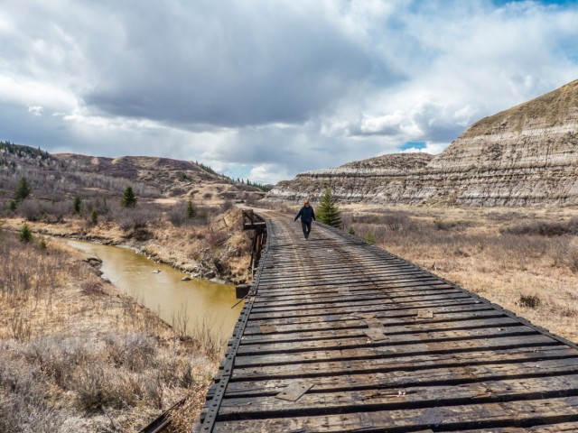
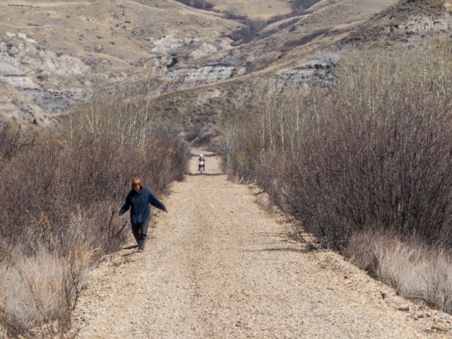
In the meantime, people have been using a the lane-width roadbed for recreation purposes. Evidence of 4×4 tire marks and a passing motorcyclist confirmed that. With some work, it’d sure make a good a multi-use trail, in fact it’s ideal for this unlike most prairie lines so converted (which travel through the featureless plains). This one instead passes through the very scenic Alberta Badlands, home to lots of nature and very few people. It’s nice and remote and amazingly scenic, as our pictures will prove. It’s got a lot of potential.
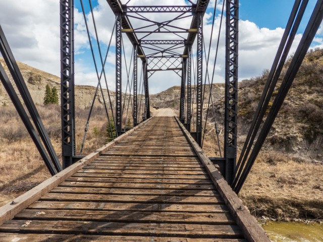
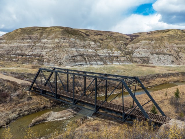
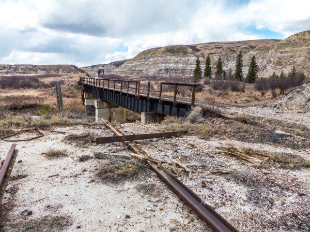
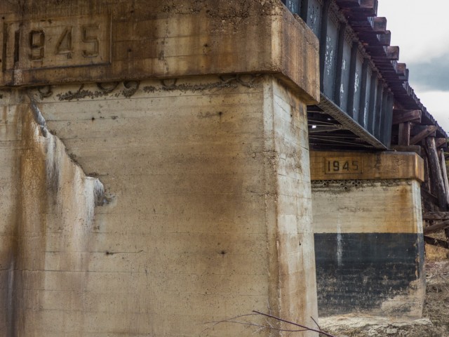
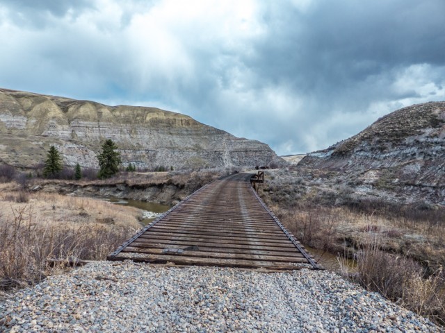
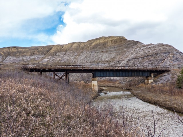
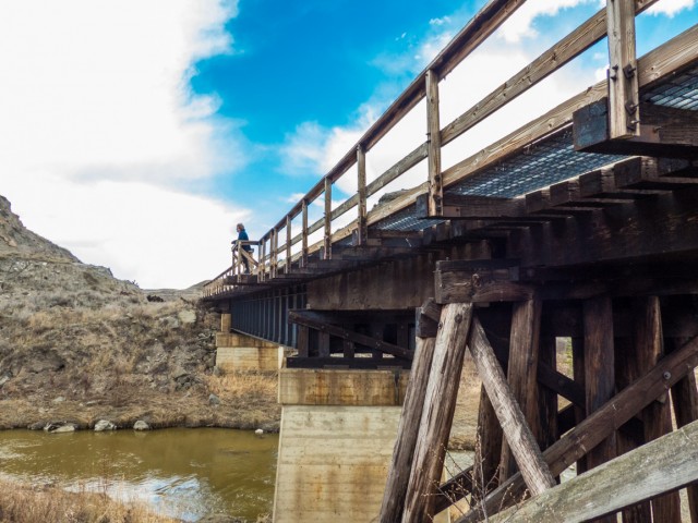
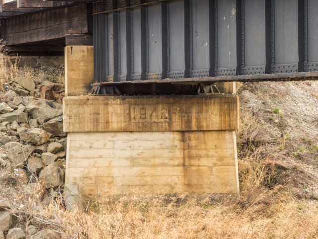
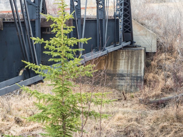
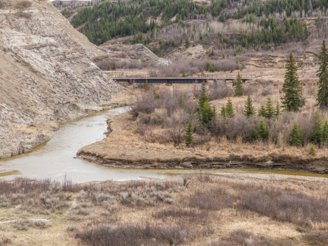
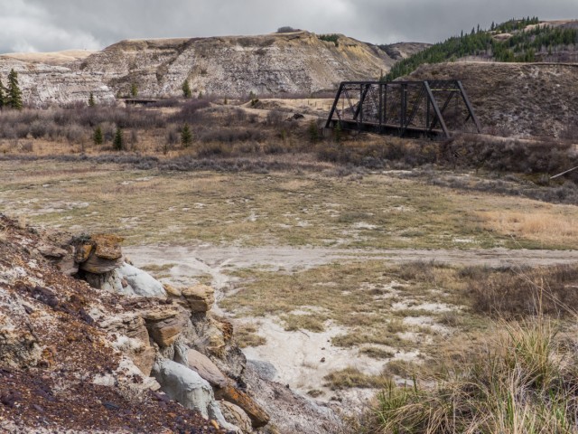
The section we explored, perhaps a click or so in length, crosses the river four times, three on deck-plate (open top) spans and one using a through truss (it’s a Pratt style, commonly used by railways). All the bridge piers are dated, showing they are from the 1940s. They replaced worn out wood-pile trestles – some of the current spans still have pile ends – which go back to the time when the line was constructed.
It’s not known who built the current steel components. We looked for builder’s plates or evidence of factory marks, but could find none. Dominion Bridge maybe? They were the country’s biggest and longest lasting bridge making firm.
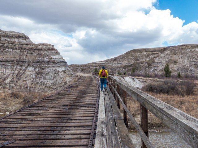
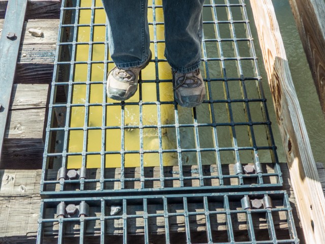
Two of the bridges have side walkways. On the others, we had to tie-hop, taking great care as it’d be easy to fall between them and snap an ankle. This author is rather scared of heights and even though these bridges are not that high, looking through the grates or ties with a view down to the water, was, well, a bit uncomfortable at times.
The Rosebud River, as with all prairie watercourses, is slow and muddy. The valley here eventually meets up with the Red Deer River near Drumheller, (technically Rosedale), the most well known area within the Alberta Badlands. This offshoot valley, in contrast is not well know and has few roads passing through it. That’s what we like.
We’d love to explore the area more. There are a lot of bridges left to see. Four down, some fifty something to go. That will keep us busy for a while.
If you wish more information on what you’ve seen here, by all means contact us!
Date: April, 2015. Location: Rosebud River Valley, AB. Article sources: CNR company records, University of Alberta Press. The land status of this railway line is not known and therefore one should be cautious when exploring it.
This would make a perfect place to build a Scenic Railroad, with all the scenery that it has to offer. The lots of nature and the amazing scenic, it’s no doubt that this route can make a perfect place to build a Scenic Railroad. I would love to do a deal with CN, to make this place a Scenic Railroad, a big tourist attraction. Not just for Railfans, but for people who want to ride their bikes, who want to go on hiking, and go canoeing or kayaking.
“This one instead passes through the very scenic Alberta Badlands, home to lots of nature and very few people. It’s nice and remote and amazingly scenic, as our pictures will prove. It’s got a lot of potential.“ This route would be a perfect place to build a Scenic Railroad. It would be a perfect tourist attraction. With all the scenery that it has offer, lots of nature, the remote and amazingly scenic, and all the bridges that have been built on this line. This is no doubt a perfect place to build a scenic Railroad. I would love to do a deal with CN and make this into a big tourist attraction in Canada. Not just for Railfans, but for people who want to hike, ride their bikes/dirt bikes/horses, and to go canoeing or kayaking. Who’s in?
Agree to the millionth power – it would have made an amazing scenic railway. But the track’s since been pulled up and CNR is still holding on to the roadbed (last time we checked) for reasons not fully explained. They have plans but are not sharing them.
I’m a little late to the party, but am looking for areas to explore this summer and want to keep my holidays in Alberta. Are there any updates to this thread? Have new tracks been laid, or is hiking / biking still a possibility along this route? Of course we’ll pack along my canoe and my wife’s kayak to fully experience the Rosebud in all its muddy glory! Thank you for the work you put into these posts and posting such wonderful pictures! I look forward to your book. Cheers!
We haven’t been back there since, but I do know the railway has put up barricades and plenty of signage in other areas along that same line, to restrict access. We know someone who canoed the Rosebud. I think they walked pulling the canoe, as much as they paddled. Glad you like the site, and please drop by often.
No, CN is holding on to it (tightly) for reasons they’ve yet to explain. This suggests they have some future plans for it. Some cool vids on your channel!
Far as I know, CN has retained ownership if this line. Nobody knows why, but it is being treated somewhat differently than many abandoned lines, particularly on the prairies.
For those of us who live in the valley it was sad for sure. Rosebud has never been quite the same. We are fortunate however to have an operating elevator still being used albeit by truck not rail.
I talked to the company dismantling the line. CN sold the line, rails, ties, spikes, signs, signals, “everything” to a country in South America (Chile perhaps, I don’t recall). Obviously it is/was more economical to ship the lot than to maintain it here. IMHO CN does not have the customer base to warrant relaying the line with heavier rail. Most of the ties were in good shape (otherwise they could not have sold them) so that would not make economic sense to remove them just to re-lay new ties and rail. I’m hoping they do actually make it into a trail, however with lawyers around, the ROW would have to be sold or donated before that could happen due to liability issues, not to mention the hazardous materials cleanup that would need to be done. Unfortunately I think its going to be left to fall into a state of disrepair and eventual destruction by CN.
The rumours I’ve heard (and recall, that’s all they are) suggests CN is banking the line. A potash mine is mentioned, but I don’t know. Either way the people I spoke with, who are CN insiders, say what ever plans the company has, they would need to rebuild the line from the roadbed up including all new ties. It’s clear, they have some kind of plan.
One of the reasons that CN has shut down this line was that many bridges and trestles needed servicing and repairs. CN felt it was more feasible to dismantle the line rather than repair and replace many of the 110+ bridges on the line.
Oh yes, the bridges were a huge maintenance headache. Still, the CNR is railbanking the line and it seems they have some sort of plans for it down the road. So, the reason they closed it goes deeper than just them.
Great pictures and story. The Rosebud river valley really looks great when it greens up in the spring. There was a group called Bad Land Railway Co that tried unsuccessfully to lease the line arround 2010. They had plans to run a Tourist Train from Drumheller up the valley to Rosebud. There was an article in the Drumheller Mail about the city of Drumheller asking CN to use the rail bed as a path way. They were turned down by CN because they said they might have plans for a heavy gauge rail line in Ten years or so?
It’s sure a beautiful valley. I heard about that company who tried to save the line. I also heard, like you, that the CNR may reopen it in a few years. I called them on this and they loudly denied it. Of course, they could be pulling my chain. Either way, it’ll be interesting to see what happens.
Hey, Chris and Stewart. I just got back from Drumheller and I got to chat with a CN official walking along the line near the crossing at MP53 of the Drumheller Sub collecting spikes (I got 3). When I asked why they took down the crossings that have a ladder and go over the road, he said this: “Because they pose a safety issue if they collapse, and if people climb them. We are planning to relay track in a few years? I don’t know, but pretty soon we will re-lay heavy-gauge track. I can’t tell you much more than that.” I am pretty excited because I am very guilty on not photographing the like while I had the chance.
I heard CN might have plans to rebuild the line at some point. Officially they’ve never confirmed it to us, but employees, off the cuff, have mentioned it a few times, as it seems they did to you here. It’ll be interesting to see what happens.
We used to do something called the "pointless challenge" 🤪 and miss those days. It was so much silly fun and often frustrating as heck. In these we'd invite people to send in random photos of obscure locations, but not give any information, and then we'd track where it was and shoot something similar.
Most of these came from old family collections, as was the case here. Anyone up to resurrecting the series?
In hindsight, why didn't we pose someone in our shot?
Pointless: “Devoid of meaning (or) senseless” Merriam-Webster.
If you like what we do and want to support this ongoing project (12 years now), go here: https://www.BIGDoer.com/help-the-society/ Thanks to Connie for making this post possible.
Exploring history with Off the Beaten Path with Chris & Connie. Photo: ca1970 and 2014. Posted by Connie.
Captured on a cold, cold day many years ago. We've been passing this old house for decades and it's little changed in that time. At some point we expect to drive by and it'll be gone.
Exploring history with Off the Beaten Path with Chris & Connie. Photo: 2017. Posted by Connie.
When retired old railway cars usually get cut up for scrap. Sometimes, however, they find their way into the hands of the general public or whomever. Flat cars make good bridges, and boxcars can be transformed into storage buildings and the like. Case in point here. We see them used like this often enough and in this case, it's part of a corral.
Incidentally, this boxcar dates from 1950 and this was found by tracing the old road number, which is still visible.
Exploring history with Off the Beaten Path with Chris & Connie. Photo: 2017. Posted by Connie.
This central Alberta racetrack was never a commercial operation but instead just a fun place for car enthusiasts in the area to get together. Early '70s or thereabouts and it only lasted a few years. Even thought it's been abandoned for that long, there is no doubt what was here.
You know we like the the obscure stuff and this one fits the bill perfectly. Found by accident while backroad cruising and the history comes thanks to local car guy Mike.
Exploring history with Off the Beaten Path with Chris & Connie. Photo: 2022. Posted by Connie.
On top of little Myrtle Mountain in the Kimberley (BC) Nature Park.
There's some good wilderness fun to be had here and nice views as you can see, but the real reason we came is mining history. The whole area near the ski hill was extensively worked over a century ago and we were looking for evidence of this. We didn't find much in the area searched, but it's a big chunk of property and we hope to return to cover more ground again soon. Of all the subjects we cover, mining related is a favourite.
Still, it was a good hike and that can't be bad. Look to the comments for more info 👇.
Exploring nature and history with Off the Beaten Path with Chris & Connie. Photo: 2022. Posted by Connie.
It's a strange curiosity in south Kananaskis, there on a hillside and we have no idea who created it. We asked around and no one's completely sure about its history. In the past it showed the Canada 100 logo from 1967 but in 2017 someone changed it to reflect the country's 150th.
That's our friend Emily from DanOCan.com having a look.
Exploring history with Off the Beaten Path with Chris & Connie. Photo: 2017. Posted by Connie.
Javascript is required for this site to function. Please enable it in your browser settings and refresh this page.
Please log-in to continue... This allows unrestricted access to every post @BIGDoer.com, popups are eliminated, commenting is on and the "contact us" page is enabled.
Your social site may send you a routine notice of login.
Or signup, here: Subscriber Register ___ BIGDoer.com: Serving up POP HISTORY & other McFun!…(Mmmm, yummy bite-sized pieces.) One million plus words & tens of thousands of photos!


This would make a perfect place to build a Scenic Railroad, with all the scenery that it has to offer. The lots of nature and the amazing scenic, it’s no doubt that this route can make a perfect place to build a Scenic Railroad. I would love to do a deal with CN, to make this place a Scenic Railroad, a big tourist attraction. Not just for Railfans, but for people who want to ride their bikes, who want to go on hiking, and go canoeing or kayaking.
I doubt anyone would argue with you on the scenic potential of such a line. That valley is amazing!
“This one instead passes through the very scenic Alberta Badlands, home to lots of nature and very few people. It’s nice and remote and amazingly scenic, as our pictures will prove. It’s got a lot of potential.“ This route would be a perfect place to build a Scenic Railroad. It would be a perfect tourist attraction. With all the scenery that it has offer, lots of nature, the remote and amazingly scenic, and all the bridges that have been built on this line. This is no doubt a perfect place to build a scenic Railroad. I would love to do a deal with CN and make this into a big tourist attraction in Canada. Not just for Railfans, but for people who want to hike, ride their bikes/dirt bikes/horses, and to go canoeing or kayaking. Who’s in?
Agree to the millionth power – it would have made an amazing scenic railway. But the track’s since been pulled up and CNR is still holding on to the roadbed (last time we checked) for reasons not fully explained. They have plans but are not sharing them.
I’m a little late to the party, but am looking for areas to explore this summer and want to keep my holidays in Alberta. Are there any updates to this thread? Have new tracks been laid, or is hiking / biking still a possibility along this route? Of course we’ll pack along my canoe and my wife’s kayak to fully experience the Rosebud in all its muddy glory!
Thank you for the work you put into these posts and posting such wonderful pictures! I look forward to your book.
Cheers!
We haven’t been back there since, but I do know the railway has put up barricades and plenty of signage in other areas along that same line, to restrict access. We know someone who canoed the Rosebud. I think they walked pulling the canoe, as much as they paddled. Glad you like the site, and please drop by often.
is this location a rail trail yet
No, CN is holding on to it (tightly) for reasons they’ve yet to explain. This suggests they have some future plans for it. Some cool vids on your channel!
Now they just need to turn it into a walking/biking trail.
Now that would be something. CN’s holding on to it for some reason, so I doubt that’ll happen. Nice to dream though.
Should be used for a scenic railroad.
A little late now, but you’re right, it should have been. That valley is so stunning and it’s so long. Thanks!
Love these pictures!
Love your comment, thanks!
Far as I know, CN has retained ownership if this line. Nobody knows why, but it is being treated somewhat differently than many abandoned lines, particularly on the prairies.
Yes, I saw that too. We called them and got the brush off. One wonders. They must have plans. Heard the Potash thing, but I sense something more.
Some similarity in my area. We have Badlands here in South Dakota on the old Milwaukee Railroad.
Looked it up – yes, almost exactly the same! Thanks for sharing that.
Took a few pictures of the last train through there. The rail pulling loading train. It was pulled by sd 60 #5473.
Seen it, thanks! Such a sad image, that line seeing its very last train.
Awesome!! Thank you for sharing that!! It’s in my list of places to go.
Have fun!
For those of us who live in the valley it was sad for sure. Rosebud has never been quite the same. We are fortunate however to have an operating elevator still being used albeit by truck not rail.
Yes, what a loss. If CN didn’t want the line, it could have made an awesome scenic railway.
That truss bridge has a lacy elegance to it. Modern day truss bridges look much more chunky and functional.
I agree, those style of truss bridges look so cool. Thanks for commenting!
I talked to the company dismantling the line. CN sold the line, rails, ties, spikes, signs, signals, “everything” to a country in South America (Chile perhaps, I don’t recall). Obviously it is/was more economical to ship the lot than to maintain it here. IMHO CN does not have the customer base to warrant relaying the line with heavier rail. Most of the ties were in good shape (otherwise they could not have sold them) so that would not make economic sense to remove them just to re-lay new ties and rail. I’m hoping they do actually make it into a trail, however with lawyers around, the ROW would have to be sold or donated before that could happen due to liability issues, not to mention the hazardous materials cleanup that would need to be done. Unfortunately I think its going to be left to fall into a state of disrepair and eventual destruction by CN.
The rumours I’ve heard (and recall, that’s all they are) suggests CN is banking the line. A potash mine is mentioned, but I don’t know. Either way the people I spoke with, who are CN insiders, say what ever plans the company has, they would need to rebuild the line from the roadbed up including all new ties. It’s clear, they have some kind of plan.
One of the reasons that CN has shut down this line was that many bridges and trestles needed servicing and repairs. CN felt it was more feasible to dismantle the line rather than repair and replace many of the 110+ bridges on the line.
Oh yes, the bridges were a huge maintenance headache. Still, the CNR is railbanking the line and it seems they have some sort of plans for it down the road. So, the reason they closed it goes deeper than just them.
What stunning scenery!
It sure is. It’s a wondrous place.
Awesome, thanks for sharing these images.
And thanks for commenting!
(via Facebook)
And where are the photos of trains running through here back in the day? The photo angles are impressive…
I’m guilty of not shooting trains on this line while I had the chance.
(via Facebook)
Wonderful inspiring scenery. Thanks for posting
It sure is a photogenic valley.
Great pictures and story.
The Rosebud river valley really looks great when it greens up in the spring.
There was a group called Bad Land Railway Co that tried unsuccessfully to lease the line arround 2010.
They had plans to run a Tourist Train from Drumheller up the valley to Rosebud.
There was an article in the Drumheller Mail about the city of Drumheller asking CN to use the rail bed as a path way.
They were turned down by CN because they said they might have plans for a heavy gauge rail line
in Ten years or so?
It’s sure a beautiful valley. I heard about that company who tried to save the line. I also heard, like you, that the CNR may reopen it in a few years. I called them on this and they loudly denied it. Of course, they could be pulling my chain. Either way, it’ll be interesting to see what happens.
Hey, Chris and Stewart.
I just got back from Drumheller and I got to chat with a CN official walking along the line near the crossing at MP53 of the Drumheller Sub collecting spikes (I got 3). When I asked why they took down the crossings that have a ladder and go over the road, he said this:
“Because they pose a safety issue if they collapse, and if people climb them. We are planning to relay track in a few years? I don’t know, but pretty soon we will re-lay heavy-gauge track. I can’t tell you much more than that.”
I am pretty excited because I am very guilty on not photographing the like while I had the chance.
I heard CN might have plans to rebuild the line at some point. Officially they’ve never confirmed it to us, but employees, off the cuff, have mentioned it a few times, as it seems they did to you here. It’ll be interesting to see what happens.