
Wet Dreams
Constructed just over a century ago, the irrigation canal infrastructure seen here, located in the dry belt region of Alberta northwest-ish of Medicine Hat, near the former town of Ronalane, was never used for the purpose it was designed. This region is incredibly dry, but the soil good, and this canal was to be a lifeline to farmers who were expected to move into the area and prosper. It’s a sad tale really. People had high hopes and big plans and all that was needed was water, which the canal would provide.
But it was for nothing and with the project well underway, it all came crashing down. Money ran out, worked stopped and hopes were dashed, With no life bringing irrigation, those few settlers already in the area left and no others came.
In the end, it was all a wet dream.
Just how much different would things have been had the canal been put into service? Check out the area just to the west, near the town of Hays, where irrigation was successful. It’s home to lots of big farms which appear quite productive. In contrast the area untouched, the one where this unfinished canal was to pass through, is dry and barren, mostly undeveloped and home to few.
This ambitious project was started around 1912 and the structures and engineering work we see in this report dates from around that time. It was to be part of an extensive and circuitous canal and support reservoir system that was to come in all the way from the Bow River near Carseland (over 200km away, near Calgary). Interestingly, the water that would have passed though the canal syphon here would have crossed the same Bow River that it was sourced from, only hundreds of kilometres from where it all began!
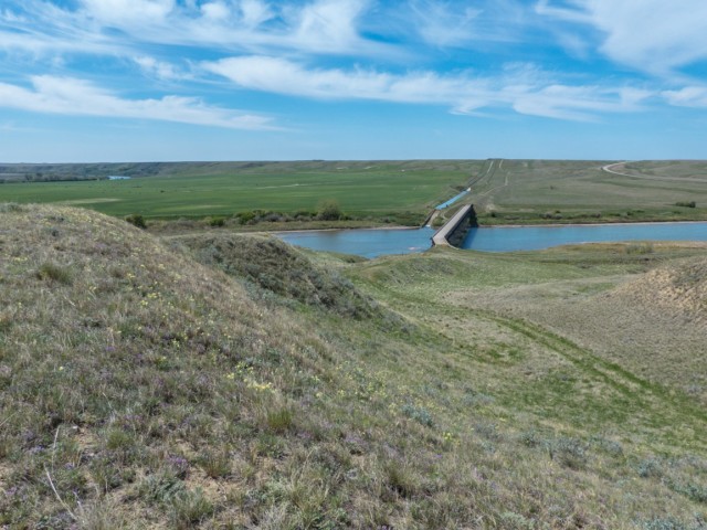
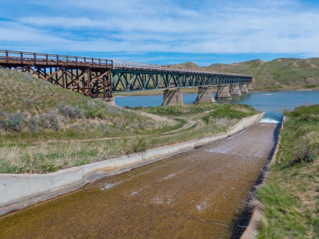
To speed construction sections of the canal were worked on concurrently, including this one, furthest away from the headwaters of the network. It turns out it was the only part not finished although some now active sections took until the 1950s to be completed, including the one that now drains into the Bow River just beside the Ronalane syphon bridge (its water source is the Bow and it empties back into it).
The original plan was to have the whole network online in just a few short years. Instead it took many decades.
The group behind this section of the canal, the Southern Alberta Land Company, was financed by a British investors. Other sections were sponsored by other organizations similarly. With the coming of World War One, money and credit from back there dried up and so work stopped. Why it was never restarted can only be speculated at. One can guess that money post war was hard to come by too. Or maybe everyone soured of the idea and lost interest.
While the canal ditch was constructed all the way from Ronalane to a point roughly halfway between Suffield and Medicine Hat, ending right beside the present Trans Canada Highway, there as plans to extend it even further.
In anticipation of irrigation some people moved into the area. They soon left however, once the canal scheme collapsed. Farming was near impossible without the water it’d bring.
A syphon (or siphon) is a large pipe, often (in the old days) made of staved wood held together with metal bands. Its purpose was simple, to connect two ends of a canal together across natural obstacles like broad valleys, This pipe, connected at each end, via a header, to the open air canal, temporarily drops down, following the lay of the land, before climbing back up the other side, where the water continues on its merry way. Think of it as a big straw of sorts that simply uses the force of atmospheric pressure to keep things moving. No pump or mechanical help is needed. As long as the upstream side is slightly higher than the downstream side, it all works. Pure and simple.
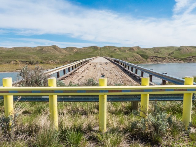
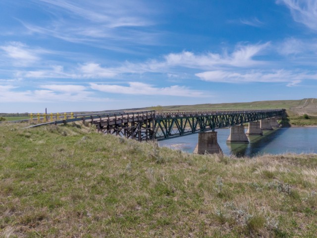
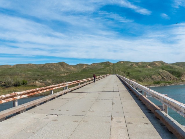
The bridge was not only built for the syphon and from the start was also designed to support a roadway too. Old documents even mention street cars using it (clearly they planned a big town here). In the end, it was used only by auto traffic, the syphon itself, recall, was never built. It’s not said but it’s presumed the pipe would be contained within the truss structure below the top deck. It looks about the right size for that purpose.
In the 1950s, the Ronalane bridge was partially destroyed by fire and rebuilt (after being fixed up just before). The current cement slab deck is from that time. In the 1990s, the structure was by-passed and a new bridge built not far away. Given the winding road leading to it and the narrow deck with that nasty elbow-curve at one end, the old bridge was probably not missed that much by drivers. It must have been quite a fun place in icy conditions.
The ends of the bridge are of wood construction. The rest is steel with concrete piers and decking. Overall it appears in good shape and shows no obvious signs of damage from 2013, when the Bow River flooded badly. A shout out to those who built the bridge.
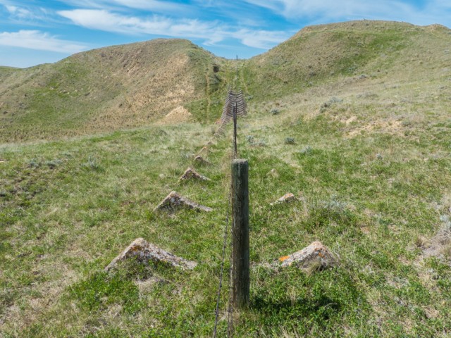
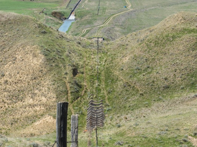
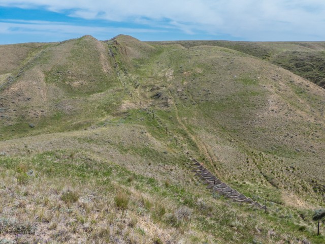
Heading up the hill are a series of concrete saddles (private property, we had permission), which would have supported the syphon. The pipe would have headed up from the bridge, drop down a little at a gully, then head up once more to meet up with the canal ditch at the valley top. A header would have been built at that end point allowing water to exit the syphon and flow into the canal.
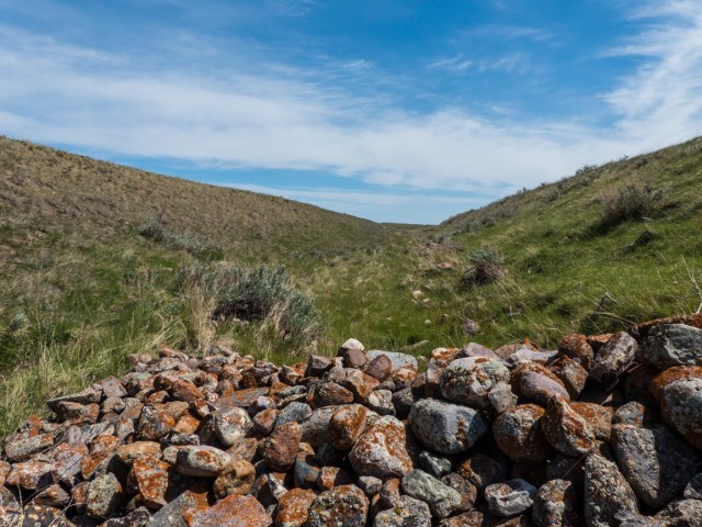
The section of ditch we explored, we hiked it about a click, appears intact and as built and even looks ready and able to hold water. Viewing it on Google Earth, it can be followed all the way to way to its end. The only altered parts are cuts where roads have dissected the canal.
The town of Ronalane (perhaps a click or so away) is now completely gone. It was located along a former railway line at the top edge of the valley. Based upon old documents, they expected irrigation to be a boon to the community and mention is made of it growing so much that it’d occupy the entire river valley here. Both sides in fact. They also speak of a streetcar connecting everything together. Ahh, big plans. Sounds almost like a promoter talking.
While exploring the bridge we came across a Bull Snake sunning itself on the wood deck portions. Easily 1.5m long, give or take, it paid us little mind. These snakes can easily be confused with rattlers, and when cornered even mimic them. A group of Pelicans (called a pod) were seen from the bridge, lazily floating down the Bow River.
The title of this report? Perhaps it’s a wee bit juvenile, we agree, but it seems to fit so well. We couldn’t resist.
We visited the same structure a number of years back…
Highway #524 abandoned road bridge.
A nearby railway bridge…
Abandoned CPR Bow River bridge.
More abandoned bridges…
Bridge hunting – Rosebud River Valley.
If you wish more information on what you’ve seen here, by all means contact us!
Date: May, 2015.
Location: Near Hays, AB.
Article sources: Hays history book: From Sod to Silver, Medicine Hat Chamber of Commerce archives, Alberta Agriculture archives.
This site is on private property and was visited with permission.
This road bridge was originally built to support a canal syphon (pipe).
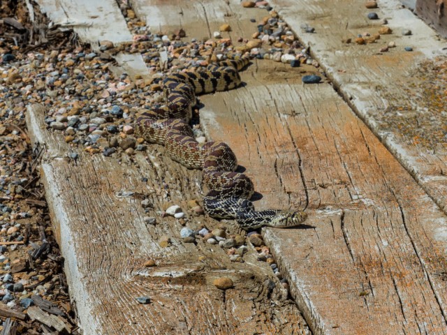
A 1.5m long bull snake suns itself on the deck.
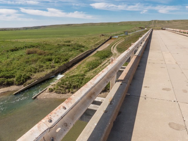
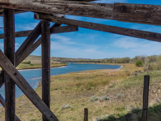
A drain from a (different) 1950s canal.
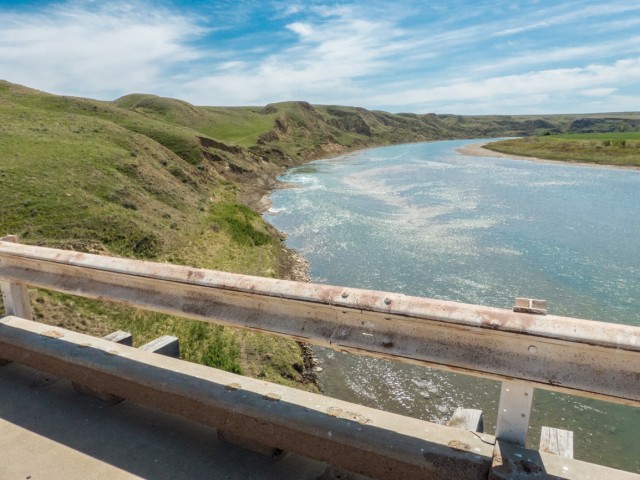
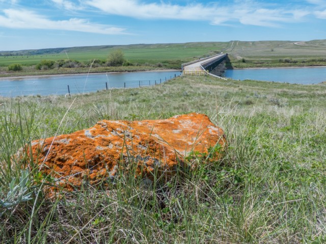
The placid Bow River.
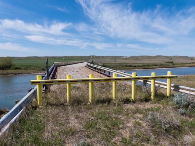
A wicked corner on this end.
The structure is close to a century old.
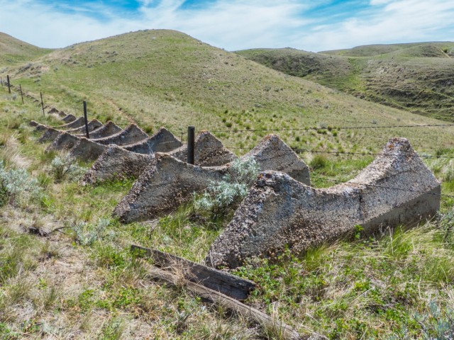
These would have supported the syphon as it dropped down to bridge level.
The project was abandoned so close to completion.
Looking down from the top.
This is where water would exit the syphon and enter the canal.
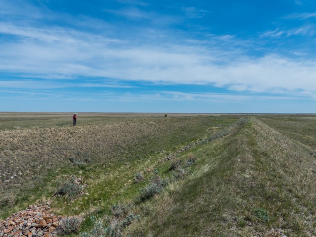
This wide ditch meanders across the dry plains for dozens of kilometres.
Looking back.
What would have come of this dry region had it been put into service?
Back at the bridge.
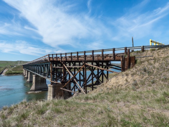
The Bow River flooded badly in 2013, but the bridge seems to have done fine.
The current road bridge in back.
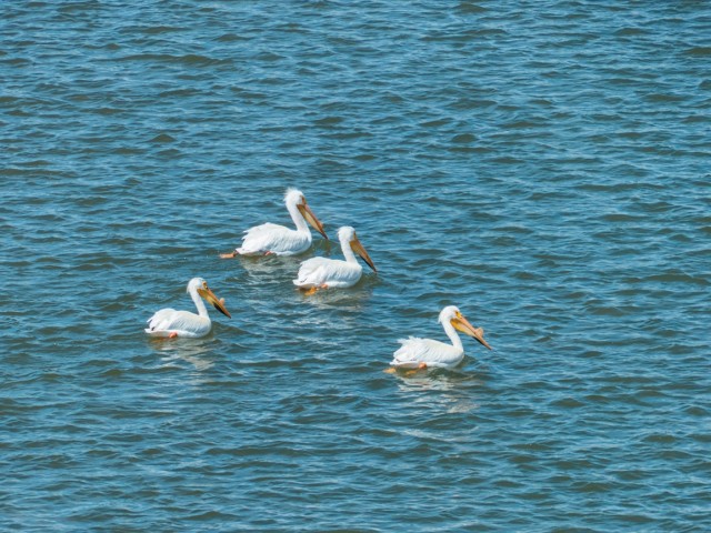
A “pod” of Pelicans.
The gap seen above the bridge was where the syphon dropped down.
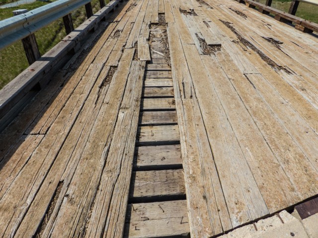
Wood sections of the deck are rotting away.
It was all a wet dream.


: Magnesium Chloride")


This is AMAZING!!! I LOVE your work… I never knew so much was riding on this canal. So many dreams, gone.
Had it worked, how different the place would have been.
So amazing the dreams and ambitions of some of these people back in the late 19th and early 20th century. We can’t fault them I guess for their lofty dreams. Back in those days, men felt, with technology and science, mother nature could always be conquered and manipulated to suit their needs. But many obstacles fell in their way. The biggest of all was usually money.
They dreamed big, and many tripped and fell, but they gave it a shot. Hard core people back then.
I love this old bridge. I remember walkin across it when I lived down that way.
When you left, the area’s population must have dropped by half! Thanks for commenting.
(via Facebook)
I always wondered about that bridge and the canals.
Now you know!
There’s an abandoned railroad bridge further upstream too.
We visited it a few years back…
https://www.bigdoer.com/2242/exploring-history/abandoned-cpr-bow-river-bridge/
Great story and pictures.
It was really sad that the first Pioneers were sold that land unseen.
It must of been such Heartbreak when they traveled so far only to find the had been sold
such poor land for farming.
Even with the water pipeline it would of been a long struggle to make Farming work in that area.
Thanks for the great reporting.
Land speculators often drew a rosy picture. Indeed even with water, farming in this part of Alberta would have been tough.