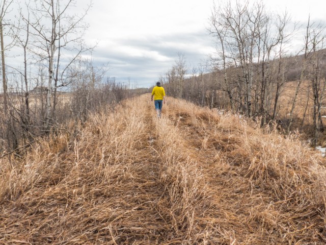
Unfinished Railway Line Calgary and file this under obscure. We’re looking at the roadbed remains of a Canadian Northern Railway branchline that was to break the Canadian Pacific Railway’s monopoly in southern Alberta. Some sections, including this one inside Calgary city limits and being encroached on by development, were built, about 1910-1912, but track was never laid. I doubt many people, even hard-core railway buffs, are aware it’s here. It’s not well known.
The section we’re seen walking is the most northerly that’s not been bulldozed under and is near the Bow River at the southern city limits. Further into town, any remains have been obliterated. (Update November 2022 and one small section further north still exists, here: Alberta Midland – CNoR Calgary.) Paying careful attention, one can still follow the line, on Google Earth, south from the where we took our photo to a point near Okotoks. A second section trending southwest from Fort MacLeod was also graded. Work on the middle was never started. The line’s planned destination was a place called Fishburn, south of present day Pincher Creek.
Why this section of track was never finished is not clear. On can guess they ran out of money or perhaps just had seconds thoughts about taking on the CPR Juggernaut.
The Canadian Northern Railway was folded into Canadian National Railways in the 1920s.
Short Subjects: reports that for any number of reasons are brief in nature. They might be updates to older articles, previews of posts planned or not yet published, brief snippets of things that don’t fit in anywhere else or subjects that are so obscure that information on them can’t be found.
If you need any more information on what we talked about here, by all means contact us!
Date of adventure: February, 2016. Location: Calgary, AB.
I just wanted to add that the actual rail line ran only as far as the former Cominco site, which is now Deerfoot Meadows. At least a kilometre south of Heritage Drive. Most of this trackage into Cominco was likely built by CPR in the early 1940’s, when the plant was opened. I don’t know when CN built the spur off their main line, but it rarely showed on old city maps. I only discovered it in the mid-80’s, driving up 11th St. SE where there was a level crossing near 59th Ave. It joined up with CP’s spur further to the south.
Yes, I recall that plant. Seems to remember steamer #6060 sitting there for a time. Way back when, I recall following the CNR’s track from the plant, north past Navajo Metals, before connecting with the still in use line just north of 46th Ave. My map shows it always was CNR and I guess was part of the line I explored in this post. Thanks for commenting!
This is a really neat find. I think there is more of this line still to be found inside the city limits and out. From just west of Sikome Lake it proceeds north across Fish Creek Park. The route then follows Bow Bottom Trail to just North of Canyon Meadows Drive there it then it more or less follows to west side of the bottom of the river valley through Lake Bonavista, Maple Ridge golf course, throught Deerfoot Meadows (east of Railway St north of Heritage Dr), then North of Glenmore Tr. through the buildings on the west side of 10 St SE, just west of Navajo Metals, through the east side of the Engineered Air building on 46 Ave SE and connecting with the CN spur behind that building. South of Okotoks in Google Earth you can see embankments on both sides of the Sheep River just west of Hwy 2 with the obvious route ending right in the middle of Hwy 2/2A interchange.
You do seem to be right. There does appear to be a short length of roadbed just north of Sikome. Can’t really say I see anything more until Navajo is reached however. Some of what you think as roadbed, I believe, is just raised earth beside Bow Bottom. a sound wall of sorts separating road from houses. I’m not sure if a line was even built here. Data seems to suggest they started around the location of Sikome and this further suggests that they had not acquired all the land they needed to the north when construction was started. Of course, the two segments would have to eventually be connected later. Indeed, I can follow the line south all the way to the Sheep River.
True, most of it has been bulldozed for Deerfoot meadows, or was never built. The ROW was definitely surveyed though, as remnants of it can still be seen in plans inside and outside the city. Check out https://alta.registries.gov.ab.ca/SpinII/logon.aspx (log on as a guest then select search->map search and zoom in on the route, there are even a few segments that show up as CNR ROW between High River and Ft McLeod though clearly none of these were ever graded. I feel kind of bad for the CNoR. They also fully graded a line from from Hanna to Medicine Hat but never laid any track south of the Red Deer River. http://forgottenalberta.com/2013/09/04/the-hanna-hat-line-withered-on-the-peavine/ . Both routes show up as dashed lines on this map http://railways.library.ualberta.ca/Maps-8-1-2/
All those planned railways! It’s just blinkin’ amazing how many there were. I’ve followed that CN line to Medicine Hat which is easily seen on Google Earth. Interesting for sure.
Check out this really cool city interactive map. They have georeferenced a set of airphotos from 1924 and overlaid them on a modern map that includes current legal boundaries.
Wicked find on that map, Kyle!! Using that map I was initially shocked to see that the berms by the Fish Creek sewage plant (that I’ve looked at for almost 40 years) were not berms related to the plant at all, but actually an ancient railway bed. Poof, mind blown!
I also managed to find a little segment of that railway bed just west of the Deerfoot Meadows to Southland drive access road. Looked over at that little swampy area thousands of times in my life without ever noticing the surprisingly linear feature right next to it. Very cool!
Did you do the careful analysis with the amazing 1924 air photo map? It’s really too bad the city didn’t reference the photos to google sattelite images, rather than a modern map, but regardless you can see that the current berms match up perfectly with what clearly looks like a continuous railway bed in 1924.
Yes, it seems to line up. No argument there. I guess what’s bugging me is they seem too high for the topography. But then, I have no idea what the rest of the park area was like before development. And of course, they could have been raised when that plant was put in, berms already in place, made higher, a cheap and easy fix. I’m still torn – I know!
Long delayed response… I was wondering the same thing, about the height, but my ol’ man figured it out…
When you follow the berm south of the creek (it serves as the road bed for a bike path) it appears to be “normal” railway height, not that weird 10ft tall thing going on by the sewer plant. But north of the creek & east of bow bottom it just keeps getting taller & taller til it eventually peters out. We suspect the reason it keeps rising is to reduce the grade for the trains climbing out of the fish creek valley level and up to the regional bow bottom valley level. When you’re driving out of the park, project the azimuth of the berm & it roughly matches up with the level of the neighborhood just to the north. It’s certainly not a big hill to climb, but I think it would naturally be steeper than a train would like.
I’ve eyed up that old roadbed from Google Earth. We and you must be the only ones interested in this type of RR archaeology. So like following abandoned lines, but ones partially built but never put into service are even more special. Can’t wait to see your pics on FB.
There was a 1900’s “coal rush” toward the Crowsnest Pass area of BC and Alberta. CP and the Great Northern from the US actually built lines into the Pass and the Canadian Northern graded this route south of Calgary. The Milwaukee Railroad from the US did a detailed survey up from Montana, and the Grand Trunk Pacific published a “wish list” map showing a GTP line paralleling the CP southern route all the way from Saskatchewan.
The hardware business is long gone but their old sign from about a century ago remains. We were doing a little walk-about in Three Hills and had a tip to look here. It's little things like this that we love the most, hidden reminders of things that came before and clues to the past that aren't so obvious.
More info in the comments👇
Exploring history with Off the Beaten Path with Chris & Connie. Photo: 2023. Posted by Connie.
The Canadian Pacific Railway at Summit Lake Crowsnest Pass in 1983 and 2023. The trains still run, but the railyard and associated infrastructure is a distant memory. Haze in the now photo is from distant forest fires. The old Summit Hotel can be seen in back in both and it's one of the few things still standing here from earlier times.
The Then photo come thanks to the John Bjorklund collection at the Center for Railroad Photography & Art and is used with permission. They sent us others and we'll hopefully be putting them to use later this year.
Go to the comments for more info 👇
Exploring history with Off the Beaten Path with Chris & Connie. Posted by Connie.
Thanks to the The Val Family for making this post possible. If you like what we do and want to support this ongoing project (12 years now), go here: https://www.BIGDoer.com/help-the-society/
Two things that make us giddy in Hodgeville Saskatchewan and now both are gone. That majestic grain elevator dates from 1967 and sadly it was torn down a few years back. There's a Canada 100 logo high up there on the cupola.
The home made motorhome is something else and locals insisted it was powered by a radial engine salvaged off a De Havilland Beaver bush plane. How in the world? The fellow who built it passed on before its completion and soon after our visit it was scrapped. Rural folks seem to have this crazy ability to craft something they need out of any old bits and pieces lying around.
Exploring history with Off the Beaten Path with Chris & Connie. Photo: 2014. Posted by Connie.
The Legion Hall and Monarch Garage, Loverna Saskatchewan, early 1990s (not 1970s as shown) and the same view in 2017. There's not much going on in Loverna these days, but long ago it was a very active and vibrant community. This was shot between takes while working on the Telus Documentary "Forgotten Prairie" by Rueben Tschetter.
Check the comments for more information. Original image thanks to and copyright Philip Brown.
Exploring history with Off the Beaten Path with Chris & Connie. Posted by Connie.
It's no secret Team BIGDoer is Boler obsessed but we're actually not owners, funny as it sounds. We can only dream and you know if we could, we would. The only thing holding us back from buying one, like the nice example seen here, is the cash to actually make the purchase and a proper vehicle to haul it around. Other than that, we're good to go!
Exploring history with Off the Beaten Path with Chris & Connie. Photo: 2021. Posted by Connie.
Javascript is required for this site to function. Please enable it in your browser settings and refresh this page.
Please log-in to continue... This allows unrestricted access to every post @BIGDoer.com, popups are eliminated, commenting is on and the "contact us" page is enabled.
Your social site may send you a routine notice of login.
Or signup, here: Subscriber Register ___ BIGDoer.com: Serving up POP HISTORY & other McFun!…(Mmmm, yummy bite-sized pieces.) One million plus words & tens of thousands of photos!


Any way I could get a special google map with the line drawn out on it?
Sorry for the delay in responding – been under the weather.
I’m afraid we lack the time…
I just wanted to add that the actual rail line ran only as far as the former Cominco site, which is now Deerfoot Meadows. At least a kilometre south of Heritage Drive. Most of this trackage into Cominco was likely built by CPR in the early 1940’s, when the plant was opened. I don’t know when CN built the spur off their main line, but it rarely showed on old city maps. I only discovered it in the mid-80’s, driving up 11th St. SE where there was a level crossing near 59th Ave. It joined up with CP’s spur further to the south.
Yes, I recall that plant. Seems to remember steamer #6060 sitting there for a time. Way back when, I recall following the CNR’s track from the plant, north past Navajo Metals, before connecting with the still in use line just north of 46th Ave. My map shows it always was CNR and I guess was part of the line I explored in this post. Thanks for commenting!
This is a really neat find. I think there is more of this line still to be found inside the city limits and out. From just west of Sikome Lake it proceeds north across Fish Creek Park. The route then follows Bow Bottom Trail to just North of Canyon Meadows Drive there it then it more or less follows to west side of the bottom of the river valley through Lake Bonavista, Maple Ridge golf course, throught Deerfoot Meadows (east of Railway St north of Heritage Dr), then North of Glenmore Tr. through the buildings on the west side of 10 St SE, just west of Navajo Metals, through the east side of the Engineered Air building on 46 Ave SE and connecting with the CN spur behind that building. South of Okotoks in Google Earth you can see embankments on both sides of the Sheep River just west of Hwy 2 with the obvious route ending right in the middle of Hwy 2/2A interchange.
You do seem to be right. There does appear to be a short length of roadbed just north of Sikome. Can’t really say I see anything more until Navajo is reached however. Some of what you think as roadbed, I believe, is just raised earth beside Bow Bottom. a sound wall of sorts separating road from houses. I’m not sure if a line was even built here. Data seems to suggest they started around the location of Sikome and this further suggests that they had not acquired all the land they needed to the north when construction was started. Of course, the two segments would have to eventually be connected later. Indeed, I can follow the line south all the way to the Sheep River.
True, most of it has been bulldozed for Deerfoot meadows, or was never built. The ROW was definitely surveyed though, as remnants of it can still be seen in plans inside and outside the city. Check out https://alta.registries.gov.ab.ca/SpinII/logon.aspx (log on as a guest then select search->map search and zoom in on the route, there are even a few segments that show up as CNR ROW between High River and Ft McLeod though clearly none of these were ever graded. I feel kind of bad for the CNoR. They also fully graded a line from from Hanna to Medicine Hat but never laid any track south of the Red Deer River. http://forgottenalberta.com/2013/09/04/the-hanna-hat-line-withered-on-the-peavine/ . Both routes show up as dashed lines on this map http://railways.library.ualberta.ca/Maps-8-1-2/
All those planned railways! It’s just blinkin’ amazing how many there were. I’ve followed that CN line to Medicine Hat which is easily seen on Google Earth. Interesting for sure.
Check out this really cool city interactive map. They have georeferenced a set of airphotos from 1924 and overlaid them on a modern map that includes current legal boundaries.
https://maps.calgary.ca/calgary1924/
You can follow the route from Railway Ave to Sikome Lake. I bet you could uncover a lot of other interesting stuff in Calgary on this map.
Great, I’ve got work to do and you show me this? Damn, that’s cool. Thanks for sharing. Oh, lots of interesting stuff there!
Wicked find on that map, Kyle!! Using that map I was initially shocked to see that the berms by the Fish Creek sewage plant (that I’ve looked at for almost 40 years) were not berms related to the plant at all, but actually an ancient railway bed. Poof, mind blown!
I also managed to find a little segment of that railway bed just west of the Deerfoot Meadows to Southland drive access road. Looked over at that little swampy area thousands of times in my life without ever noticing the surprisingly linear feature right next to it. Very cool!
I’m torn. Something about those berms suggests that’s all they are, just berms. Can’t pinpoint it but that’s just my gut feelings.
Did you do the careful analysis with the amazing 1924 air photo map? It’s really too bad the city didn’t reference the photos to google sattelite images, rather than a modern map, but regardless you can see that the current berms match up perfectly with what clearly looks like a continuous railway bed in 1924.
Yes, it seems to line up. No argument there. I guess what’s bugging me is they seem too high for the topography. But then, I have no idea what the rest of the park area was like before development. And of course, they could have been raised when that plant was put in, berms already in place, made higher, a cheap and easy fix. I’m still torn – I know!
Long delayed response… I was wondering the same thing, about the height, but my ol’ man figured it out…
When you follow the berm south of the creek (it serves as the road bed for a bike path) it appears to be “normal” railway height, not that weird 10ft tall thing going on by the sewer plant. But north of the creek & east of bow bottom it just keeps getting taller & taller til it eventually peters out. We suspect the reason it keeps rising is to reduce the grade for the trains climbing out of the fish creek valley level and up to the regional bow bottom valley level. When you’re driving out of the park, project the azimuth of the berm & it roughly matches up with the level of the neighborhood just to the north. It’s certainly not a big hill to climb, but I think it would naturally be steeper than a train would like.
Delays are no problem. It’s not when you respond but that you do. You may indeed be right there. They certainly were working in the area.
We were out there on the weekend, took photos of the former CNoR railbed NW of Suffield. A very desolate area.
I’ve eyed up that old roadbed from Google Earth. We and you must be the only ones interested in this type of RR archaeology. So like following abandoned lines, but ones partially built but never put into service are even more special. Can’t wait to see your pics on FB.
There was a 1900’s “coal rush” toward the Crowsnest Pass area of BC and Alberta. CP and the Great Northern from the US actually built lines into the Pass and the Canadian Northern graded this route south of Calgary. The Milwaukee Railroad from the US did a detailed survey up from Montana, and the Grand Trunk Pacific published a “wish list” map showing a GTP line paralleling the CP southern route all the way from Saskatchewan.
Amazing all the lines that were proposed. Thanks a million for commenting!
Neat find!
Hard to believe it’s in the city!