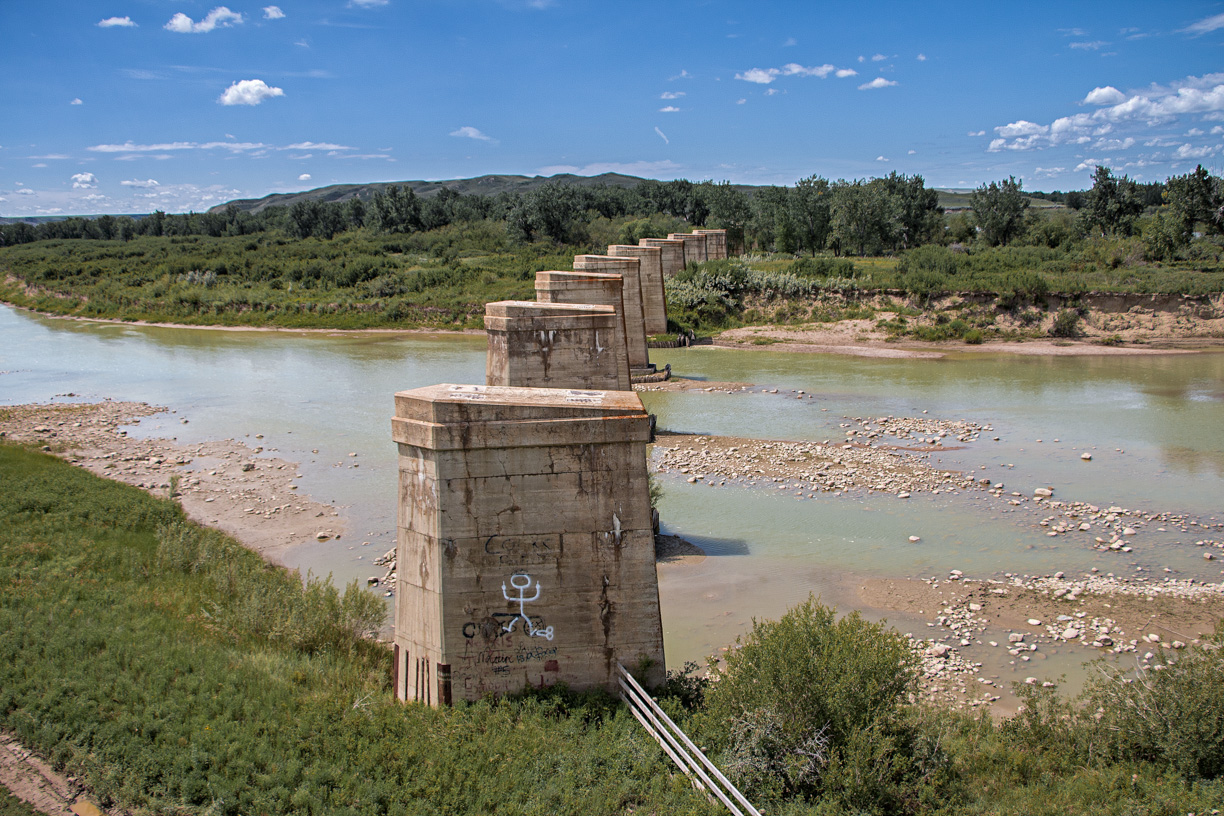
Bridges, we love bridges! In fact, we can’t get enough of them! The fine bit of engineering we’ll be looking at today was a mighty one, approaching three quarters of a kilometre in length from end to end (fractions with metric, shame on me). About a century old, it once carried a railway line over a broad meandering river just inside the Saskatchewan border. Today only the piers remain, lots of them, plus the old roadbed leading to each end, the decks that supported the trains long removed.
Our viewpoint didn’t allow us to see the remains in their entirety. Still, what an incredible sight. Big and long, so lonely, so remote, so forgotten. We really hope to return some day and came no where close to getting enough this trip. Not nearly so. The three photo presented don’t do it justice. It’s that good a subject and needs further exploration.
Empress Subdivision Bridge: remains of a century old structure that once carried trains across the South Saskatchewan River. Researched, written and photographed by Chris Doering and Connie Biggart (BIGDoer.com)
The line here was the Canadian Pacific Railway’s Empress Subdivision running from it namesake town just across the line in Alberta to a point in the east near Swift Current where it joined up with the mainline. Built in the 1910s it was a conduit for grain moving out of the area, and later for coal coming from the Red Deer River Valley near Drumheller and bound for southern Saskatchewan markets. In the 1930s-1950s in particular, a lot of it moved along the line. It was heating fuel.
↓ ↓ ↓ ↓ Scroll down for photos and to comment ↓ ↓ ↓ ↓
The bridge was a huge undertaking and held up completion of the line for many, many months. Makes sense, since it was the greatest engineering challenge along the line and kept lots of men busy for quite some time. Interestingly, we found what appears to be the location of a fair-sized yard along the old line, to the east, which presumably was the staging area for materials coming to the site. It’s easily four tracks wide and we can’t think what other purpose it could have served outside what we’re guessing at.
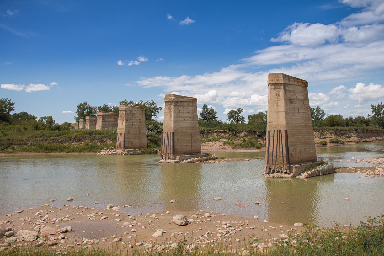
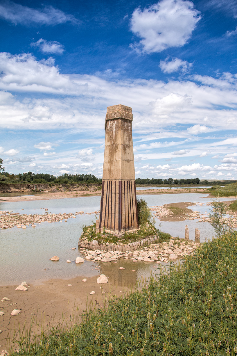
The bridge is compromised of some thirty plus concrete piers, equidistant from each other. This allowed the many spans needed to be identical to each other, thereby reducing costs. Even so, this was of course a pricey endeavour, and was one of the longest bridges on the entire system. Any CPR records we searched did not make mention who built the spans. Dominion Bridge seems like a likely candidate though. They were the largest such firm in the country, by a fair stretch.
Spans were a deck plate style, so open topped with support beams underneath. All were the same.
The structure was straight for most of its length. One the east end, so the side we visited, there was a curve with an obvious cant (or super-elevation). This suggests track speeds here were fairly brisk. Embedded in the piers are some old rails which helped reinforced the leading edge against wear from moving ice and the like.
Blocking most of the structure from view is a large island. What we can see from this position is perhaps one quarter of its length! The South Saskatchewan sure is a wide water course. In hindsight, your author should have climbed up the river valley a bit to get an overall better view. Not sure why it failed to cross my mind. Next time. Next time!
The line here, from Empress to Leader Saskatchewan was closed in around 1990 – the east end still sees trains though. Since the coal markets died in the 1960s traffic was a mere trickle here anyway. Soon afterwards the spans were removed. It’s understood many were reused in other places. Into the late 1990s, a number of them languished away in the old Empress Alberta rail yards. The nearest community to the structure was Estuary Saskatchewan but it’s a ghost town now.
The last passengers run to cross over the bridge was in the early 1960s.
A few hours before that very same day we tried to approach the bridge from the west side, with the land owner’s permission, but were turned back several kilometres away due to a slump in the road. Actually the old railway bed turned road. Hiking in would have been an option any other day but not this one. By the way there is very little civilization within sight of the bridge and at best limited access via very rough roads, or on the west side, no roads at all (anyway recall it’s private land there). You could of course canoe or kayak in. The river is big but come mid-summer is quite placid.
Given the scarcity of photos found, online or elsewhere, from any date, it’s clear the structure was or is rarely ever visited. Few know of it so we feel extra special that we got to experience its splendour. It sure is impressive! What a thrill it would have been to crossing it on a train.
On this adventure we hung around with good friends Jason and Rebecca Sailer of Lethbridge. A big thanks goes out to them. I think Jason was as thrilled to see the structure as I was. I’ve been dreaming of visiting it for decades, even since I saw it in a Greg McDonnell book. If you’d like to host or join up with BIGDoer.com on a some trip, drop us a line. We love to collaborate.
I am really enjoying your photos. If I remember correctly many of the steel spans from this bridge were used to replace timber trestles on other lines. I can not remember the exact locations but they were probably in SASK. The lengths of the spans were perfect to allow placement of new concrete piers exactly between the bents (timber piers) of the timber trestles (so the piers could be constructed and traffic maintained over the trestles during most of construction). I was working in the Bridge Dept at CPR in Montreal at the time. Cheers.
We heard that before and it makes complete sense given the frugal nature of railways. They were recycling before it was cool. That sure was a lot of spans! When we visited Empress in the 1990s, there was a number of them sitting down by the old rail yard.
Wow, thank you all so much for sharing! The time for researching the history, the pictures, your personal time is greatly appreciated!! Love your site!
Yes definitely Chris, In the spring we will go to the west end to my friend’s property to get that perspective. I also have a side trip lined up for you and Connie in the Hilda area, try to hit them at the same time.
A bridge of my youth. I remember crossing the bridge by foot with my girl friends, even though we knew the rail schedule we imagined that we could hear one coming, thrilling and scary.
My Dad worked this line back in the 50’s-60’s for the CPR. It was known as the Empress Grain Train. Not sure if the bunkhouse is still standing in Empress. Very big grain -producing area requiring its own line. How he would have enjoyed your site!
It sounds like these old bridge supports are surrounded by private land so the public can’t view it. Too bad as this would become a destination if it was more accessible. Still, I’m glad to at least be able to read about it in my favourite blog.
Me again. I found this youtube video you and your readers might be interested in. It talks about the very bridge and rail bed you visited from what I have researched.
We used to do something called the "pointless challenge" 🤪 and miss those days. It was so much silly fun and often frustrating as heck. In these we'd invite people to send in random photos of obscure locations, but not give any information, and then we'd track where it was and shoot something similar.
Most of these came from old family collections, as was the case here. Anyone up to resurrecting the series?
In hindsight, why didn't we pose someone in our shot?
Pointless: “Devoid of meaning (or) senseless” Merriam-Webster.
If you like what we do and want to support this ongoing project (12 years now), go here: https://www.BIGDoer.com/help-the-society/ Thanks to Connie for making this post possible.
Exploring history with Off the Beaten Path with Chris & Connie. Photo: ca1970 and 2014. Posted by Connie.
Captured on a cold, cold day many years ago. We've been passing this old house for decades and it's little changed in that time. At some point we expect to drive by and it'll be gone.
Exploring history with Off the Beaten Path with Chris & Connie. Photo: 2017. Posted by Connie.
When retired old railway cars usually get cut up for scrap. Sometimes, however, they find their way into the hands of the general public or whomever. Flat cars make good bridges, and boxcars can be transformed into storage buildings and the like. Case in point here. We see them used like this often enough and in this case, it's part of a corral.
Incidentally, this boxcar dates from 1950 and this was found by tracing the old road number, which is still visible.
Exploring history with Off the Beaten Path with Chris & Connie. Photo: 2017. Posted by Connie.
This central Alberta racetrack was never a commercial operation but instead just a fun place for car enthusiasts in the area to get together. Early '70s or thereabouts and it only lasted a few years. Even thought it's been abandoned for that long, there is no doubt what was here.
You know we like the the obscure stuff and this one fits the bill perfectly. Found by accident while backroad cruising and the history comes thanks to local car guy Mike.
Exploring history with Off the Beaten Path with Chris & Connie. Photo: 2022. Posted by Connie.
On top of little Myrtle Mountain in the Kimberley (BC) Nature Park.
There's some good wilderness fun to be had here and nice views as you can see, but the real reason we came is mining history. The whole area near the ski hill was extensively worked over a century ago and we were looking for evidence of this. We didn't find much in the area searched, but it's a big chunk of property and we hope to return to cover more ground again soon. Of all the subjects we cover, mining related is a favourite.
Still, it was a good hike and that can't be bad. Look to the comments for more info 👇.
Exploring nature and history with Off the Beaten Path with Chris & Connie. Photo: 2022. Posted by Connie.
It's a strange curiosity in south Kananaskis, there on a hillside and we have no idea who created it. We asked around and no one's completely sure about its history. In the past it showed the Canada 100 logo from 1967 but in 2017 someone changed it to reflect the country's 150th.
That's our friend Emily from DanOCan.com having a look.
Exploring history with Off the Beaten Path with Chris & Connie. Photo: 2017. Posted by Connie.
Javascript is required for this site to function. Please enable it in your browser settings and refresh this page.
Please log-in to continue... This allows unrestricted access to every post @BIGDoer.com, popups are eliminated, commenting is on and the "contact us" page is enabled.
Your social site may send you a routine notice of login.
Or signup, here: Subscriber Register ___ BIGDoer.com: Serving up POP HISTORY & other McFun!…(Mmmm, yummy bite-sized pieces.) One million plus words & tens of thousands of photos!


")


I am really enjoying your photos. If I remember correctly many of the steel spans from this bridge were used to replace timber trestles on other lines. I can not remember the exact locations but they were probably in SASK. The lengths of the spans were perfect to allow placement of new concrete piers exactly between the bents (timber piers) of the timber trestles (so the piers could be constructed and traffic maintained over the trestles during most of construction). I was working in the Bridge Dept at CPR in Montreal at the time. Cheers.
We heard that before and it makes complete sense given the frugal nature of railways. They were recycling before it was cool. That sure was a lot of spans! When we visited Empress in the 1990s, there was a number of them sitting down by the old rail yard.
Wow, thank you all so much for sharing! The time for researching the history, the pictures, your personal time is greatly appreciated!! Love your site!
That fills us with joy to hear that you appreciate our work so much. Thank you!
This was a secondary mainline built by CPR to bypass the pusher grades on both sides of Medicine Hat. Lots of grain used to go this way.
And coal from the Drumheller area.
Once the mainstay of commerce, now an eerie ghost.
That’s it exactly.
Sentinels to the past? Was a new, better crossing built?
No, the line was simply abandoned and the bridge decks removed.
Aww yes I remember that was fun to see up close!
Maybe time for a revisit?
Yes definitely Chris, In the spring we will go to the west end to my friend’s property to get that perspective. I also have a side trip lined up for you and Connie in the Hilda area, try to hit them at the same time.
Awesome!
Quite interesting to see all of the piers on Google maps.
There’s a whole lot of them!
I guess it would be too expensive to remove them. Nice photos.
Yes, that’s the exact reason. And so they stand for all eternity. Glad you liked them!
Sad ending.
All things must go away I suppose.
Amazing – I’d love to see old pics of when it was in use.
There’s a photo, I think in a Greg McDonnell book, showing a train crossing it. It’s a stunning pic as I recall.
Another good story that as usual led me to do some digging. Interesting history of the line. Thanks guys.
Aw shucks! Happy to share this with you.
A bridge of my youth. I remember crossing the bridge by foot with my girl friends, even though we knew the rail schedule we imagined that we could hear one coming, thrilling and scary.
Give the length of the bridge…that’s insanity!
They always take the valuable scrap iron and leave the concrete for the next thousand years.
It’s just too expensive to remove. In the 1990s a number of the removed spans sat at near the Empress Yards. I suspect some were reused elsewhere.
My Dad worked this line back in the 50’s-60’s for the CPR. It was known as the Empress Grain Train. Not sure if the bunkhouse is still standing in Empress. Very big grain -producing area requiring its own line. How he would have enjoyed your site!
That’s so nice to hear he’d like what we do. All that’s left in Empress is the restored station. Yes, it was a busy line.
I’ve been there dozens of times. Popular fishing spot for locals at one time. This spot is near the enigmatic early trading post of Fort Chesterfield.
Looks like a nice fishing spot. Ah Fort Chesterfield…will have to look that up.
so sad
Indeed.
It sounds like these old bridge supports are surrounded by private land so the public can’t view it. Too bad as this would become a destination if it was more accessible. Still, I’m glad to at least be able to read about it in my favourite blog.
The west side approach is on private land but the east side does have a road to it. Glad you like what we do – do come back often!
There is a train bridge SW of Red Deer that was abandoned 30 something years ago. It was originally the ACR line.
I know if it and have been hoping to visit it sometime. Thanks for commenting!
Shortest route from Swift Current to Calgary.
I heard that many times. Yet it was still abandoned. Maybe this costly to maintain bridge was the reason?
Hi Chris & Connie,
Me again. I found this youtube video you and your readers might be interested in. It talks about the very bridge and rail bed you visited from what I have researched.
https://www.youtube.com/watch?v=wpH6z5ClpKw
If i find any more info about this bridge, I will share it with you.
Cheers
Awesome video! If you have more to share, we’d love to see it.
Excellent post!
Thank you and be sure and come back often.
Everything the CPR built around that time has been abandoned!
I know, so many lines and now so few. What a loss!
Love this kind of post! The huge piers look like ancient Egyptian monuments – and monuments they are – to an era of railroad expansion. Fascinating!
Indeed they are monuments. Interesting comparison.
(via Facebook)
You finally made it! Get in from the west side as well?
Tried but got turned back at a slump. Will try again. Might have to walk in.
(via Facebook)
Been there! Kayaked the river.
Now that sounds cool! I’m jealous.
Thank you for sharing this. And keep up the good work.
Will do! And keep coming back!
I was excited! Glad we checked it out, and am looking forward to seeing the west end.
Me too. I REALLY enjoyed seeing it.
Great write-up Chris! So much lost railroad history on the prairies!
Thank you, glad you like it! Yes, so many lines pulled up and forgotten.