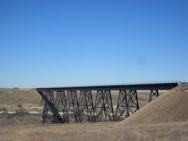
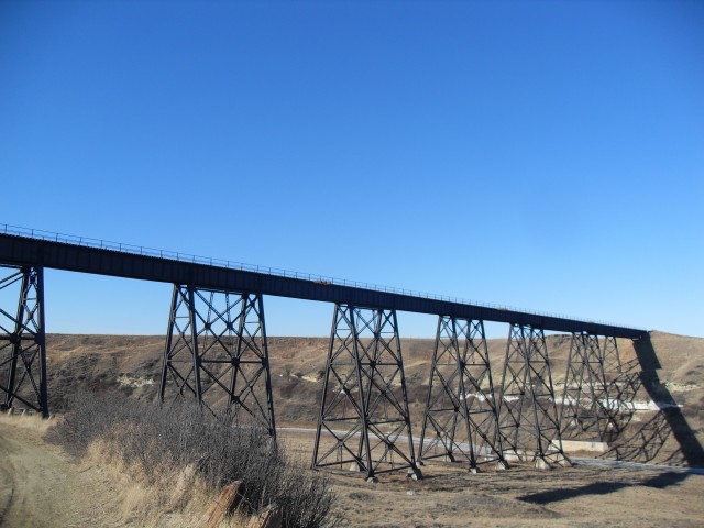
When one thinks of large train bridges in Alberta or even Canada for that matter, the Lethbridge Viaduct instantly comes to mind for most. Its massive size means an equally massive notoriety and it’s clearly the most famous of its type. However scatted nearby throughout the southern half of the province are a number of interesting railway bridges of similar appearance and of substantial size, like the one seen here in Carmangay Alberta.
Located on CPR’s Aldersyde Subdivision the bridge is just north of the village, which itself is some sixty kilometres north of Lethbridge. Access is easy and one can view the structure by following an easy and marked foot path that takes you to its base.
Alas there were no trains to be seen on our visit which is always a bummer. This is a secondary line home to perhaps a half dozen freights per day (give or take a huge margin – I’ve heard as many as ten, and as few as one). The lay of land allows for some very good train pictures to be taken should one arrive, but we were not so fortunate. No worries, the bridge itself is still very photogenic.
↓ ↓ ↓ ↓ Scroll down for photos or to comment ↓ ↓ ↓ ↓
The rail line came through here in the years 1910-11 and in fact Carmangay was the northern terminus of the line for a short time while the bridge was being built (not the one we see, but an earlier one). As a result it was a boom town for a few fleeting seasons.
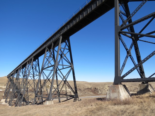
The original structure was a large but temporary wooden trestle spanning the valley with a steel section only over the river. These types of bridges were often used on newly constructed lines as they could be quickly built allowing traffic to flow with a minimum of delay. Being made of wood however means they are quite a maintenance nightmare and when time and money allowed they were often replaced by steel spans.
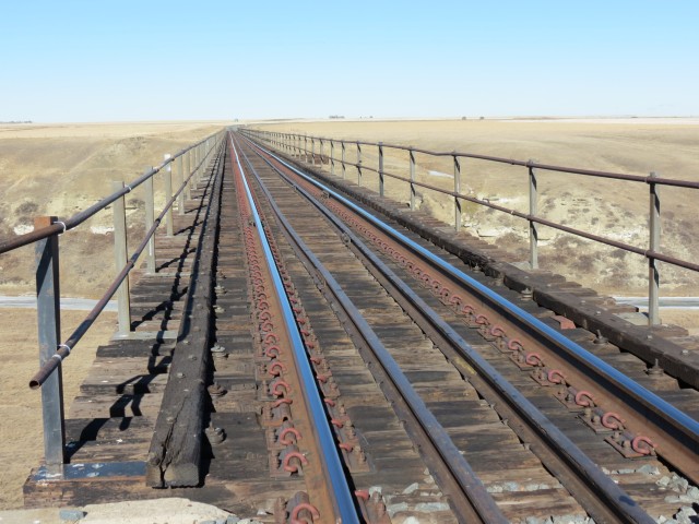
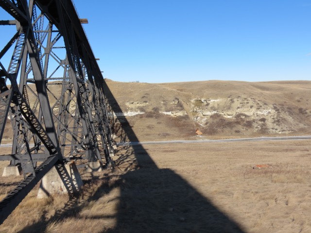
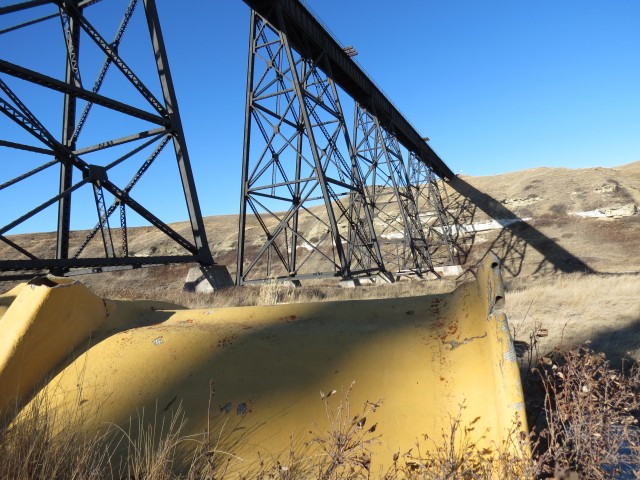
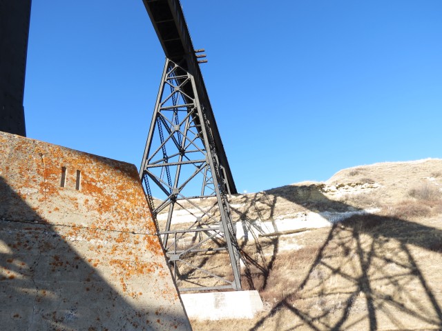
As was the case here and the structure we see is dated 1927 on one of its piers. In addition, the approach ways on the southern side were filled in with earth allowing the new span to be shorter in length. An interesting feature is that each pier or pier set is numbered, starting from the south.
At the north end of the bridge there is a steep drop and the strata shows bands of sandstone layered in the soil. The bank on the south end has a totally different personality and the grade from the coulee bottom up to the rail line is quite gentle in comparison.
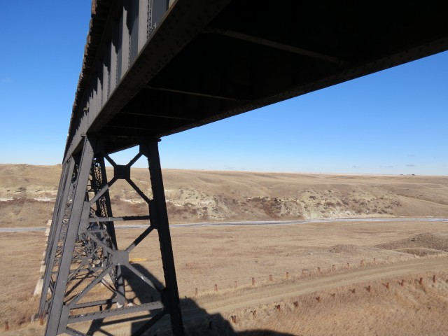
While nowhere near as large as Lethbridge’s this example is still a huge piece of engineering and is quite a sight to see. One thing I find fascinating, even though it was built some eighty five years ago, it has no trouble supporting the much heavier trains of today. It seems that railway infrastructure was always overbuilt, reflecting the “make this thing last as long as possible” attitude these firms subscribed to.
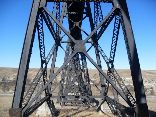
Published data on the bridge lists it as 150m long and 44m high. The famous railway construction firm of Foley, Stewart and Welch was listed as the original contractor. It’s not know however if they built the the original or put in place the current one, or perhaps they did both. This company is well know for constructing many railway lines in Canada.
In the case of bridges like this, components were supplied by a outside steel firm. Perhaps Dominion Bridge, who seemed to be the most prolific supplier of that era. This is just a shot in the dark though and this author did not find a builders plate on the structure confirming who made the steel bits.
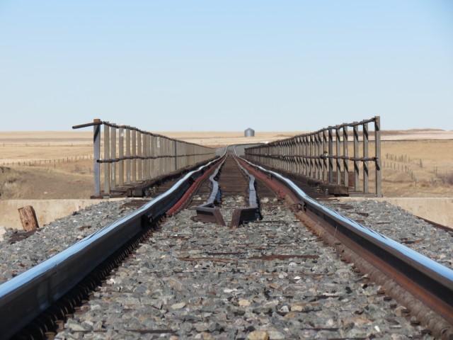
One thing of interest to those viewing the pictures is the state of the track on the bridge. It appear quite uneven, but this is mostly an optical illusion due to the length of zoom being used.
The river here is called the Little Bow which heads south of Carmangay before finally draining into the Oldman River near Picture Butte. While this little shallow waterway shares a name with the much larger Bow River to the north, the two do not connect. The Bow River is less than a kilometre from my home. Found near the watercourse was the remains of a fibreglass mold. Who knows where it’s from and how it got here (wind?) is anyone’s guess.
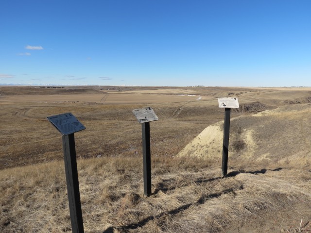
There is evidence of aboriginal peoples having populated this coulee for many thousands of years and nearby one can find evidence of tipi (or is it teepee) rings. These are circular groupings of large rocks that were used to anchor the bottom animal hide lip of the lodge.
While not clear in my pictures, there is remains of an old road into town nearby. One can see the cuts and fills as it travelled down into the valley, crossing a gully and later the river before finally looping under the train bridge and heading south into Carmangay. The current highway by passes the town by perhaps a couple kilometres.
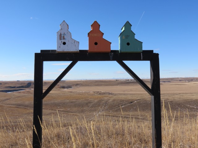
Some unique grain elevator shaped birdhouses were found on the trail to the bridge. The same day we explored this area, we also visited the nearby town of Champion Alberta.
To see the very photogenic Emmanuel Anglican Church in Carmangay, follow this link… Little Church on the prairie.
To see the much larger but otherwise similar looking bridge in nearby Monarch Alberta, go here… Bridge hunting – Monarch Alberta.
If you wish more information on this place, by all means contact us!
I am not sure, but the fibreglass piece may be the cover off a car used to transport coils of steel. When I worked for CP, they were known to blow off.
To others it’s a plain old boring train bridge but your write ups transform it into something so interesting. You sound like my young boy who must explore and investigate everything. What an amazing blog!
We used to do something called the "pointless challenge" 🤪 and miss those days. It was so much silly fun and often frustrating as heck. In these we'd invite people to send in random photos of obscure locations, but not give any information, and then we'd track where it was and shoot something similar.
Most of these came from old family collections, as was the case here. Anyone up to resurrecting the series?
In hindsight, why didn't we pose someone in our shot?
Pointless: “Devoid of meaning (or) senseless” Merriam-Webster.
If you like what we do and want to support this ongoing project (12 years now), go here: https://www.BIGDoer.com/help-the-society/ Thanks to Connie for making this post possible.
Exploring history with Off the Beaten Path with Chris & Connie. Photo: ca1970 and 2014. Posted by Connie.
Captured on a cold, cold day many years ago. We've been passing this old house for decades and it's little changed in that time. At some point we expect to drive by and it'll be gone.
Exploring history with Off the Beaten Path with Chris & Connie. Photo: 2017. Posted by Connie.
When retired old railway cars usually get cut up for scrap. Sometimes, however, they find their way into the hands of the general public or whomever. Flat cars make good bridges, and boxcars can be transformed into storage buildings and the like. Case in point here. We see them used like this often enough and in this case, it's part of a corral.
Incidentally, this boxcar dates from 1950 and this was found by tracing the old road number, which is still visible.
Exploring history with Off the Beaten Path with Chris & Connie. Photo: 2017. Posted by Connie.
This central Alberta racetrack was never a commercial operation but instead just a fun place for car enthusiasts in the area to get together. Early '70s or thereabouts and it only lasted a few years. Even thought it's been abandoned for that long, there is no doubt what was here.
You know we like the the obscure stuff and this one fits the bill perfectly. Found by accident while backroad cruising and the history comes thanks to local car guy Mike.
Exploring history with Off the Beaten Path with Chris & Connie. Photo: 2022. Posted by Connie.
On top of little Myrtle Mountain in the Kimberley (BC) Nature Park.
There's some good wilderness fun to be had here and nice views as you can see, but the real reason we came is mining history. The whole area near the ski hill was extensively worked over a century ago and we were looking for evidence of this. We didn't find much in the area searched, but it's a big chunk of property and we hope to return to cover more ground again soon. Of all the subjects we cover, mining related is a favourite.
Still, it was a good hike and that can't be bad. Look to the comments for more info 👇.
Exploring nature and history with Off the Beaten Path with Chris & Connie. Photo: 2022. Posted by Connie.
It's a strange curiosity in south Kananaskis, there on a hillside and we have no idea who created it. We asked around and no one's completely sure about its history. In the past it showed the Canada 100 logo from 1967 but in 2017 someone changed it to reflect the country's 150th.
That's our friend Emily from DanOCan.com having a look.
Exploring history with Off the Beaten Path with Chris & Connie. Photo: 2017. Posted by Connie.
Javascript is required for this site to function. Please enable it in your browser settings and refresh this page.
Please log-in to continue... This allows unrestricted access to every post @BIGDoer.com, popups are eliminated, commenting is on and the "contact us" page is enabled.
Your social site may send you a routine notice of login.
Or signup, here: Subscriber Register ___ BIGDoer.com: Serving up POP HISTORY & other McFun!…(Mmmm, yummy bite-sized pieces.) One million plus words & tens of thousands of photos!


")


")


I am not sure, but the fibreglass piece may be the cover off a car used to transport coils of steel. When I worked for CP, they were known to blow off.
Others have suggested that too. It’s been so long now, I can’t say for certain. Thanks for commenting!
To others it’s a plain old boring train bridge but your write ups transform it into something so interesting. You sound like my young boy who must explore and investigate everything. What an amazing blog!
Aw shucks! It’s my pleasure to write these articles. Connie always says I’m like a little kid when it comes to exploring.