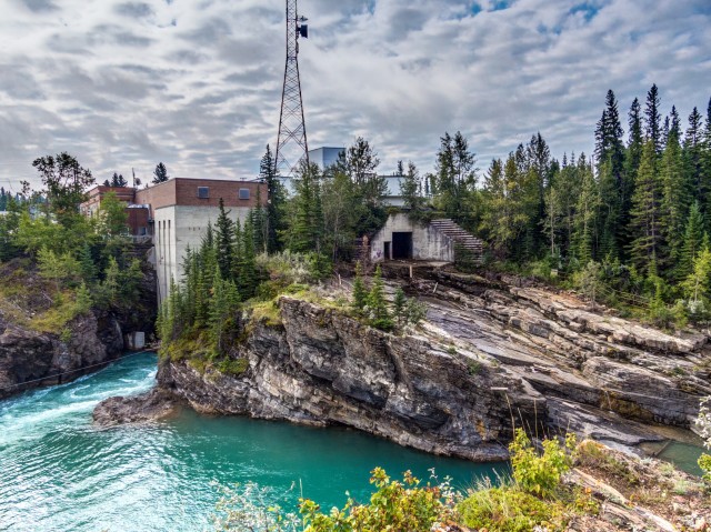
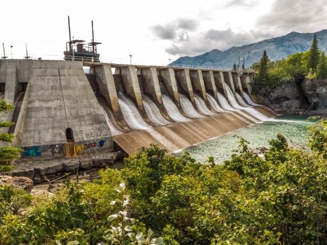
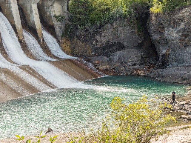
The Seebe Dam, called the Kananaskis Plant by its owner, is just over a century old and is located along the scenic Bow River west of Calgary, where the mountains meet the plains. We’re in the area for a hike and take some time to study this interesting old structure before heading down the trail. It’s big, it’s humongous, it’s amazing piece of retro engineering and as such we can’t pass it by. We must explore!
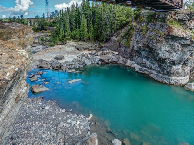
This was one of two dams we’d visit this trip and the second will be documented in separate article sometime soon. The skies were nice and blue this day and the waters an amazing teal. What a great day for photography.
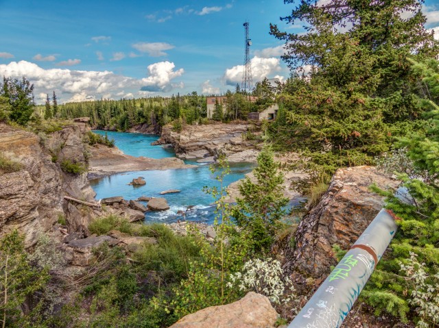
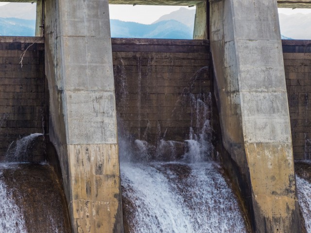
The dam was built in 1913 where the Bow and Kananaskis Rivers meet, at the location of Kananaskis Falls, now underwater, at a place later named Seebe, and is used to generate electricity. The current operator is Trans Alta Utilities. In the past, it belonged to Calgary Power. The facility does not require water be stored in a traditional style massive-scale reservoir (there is a small one however) and for the most part the natural flow of the river itself is enough to power all the generating equipment. As such, this means the structure’s impact on the surrounding countryside is greatly lessened – no huge man-made lakes taking up real estate for example.
↓ ↓ ↓ ↓ Scroll down for photos or to comment ↓ ↓ ↓ ↓
The facility generally only produces power when demand requires it. At other times, it’s on standby but it able to come up to speed very quickly. Water is directed into an canal then an intake channel and is run through the turbines and exits back into the Bow River via a tunnel cut into the the bedrock perhaps a half a click downstream. The generating plant is on the south side of the river and is naturally off limits. The water level in the small holding reservoir is controlled by large wood planks placed in slots in the spillway. A simple solution.
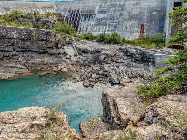
This structure was inundated by the spring 2013 floods and outside a buildup of debris on the upstream face (being cleaned up), it appears to have suffered little. I guess that speaks highly of those who built it.
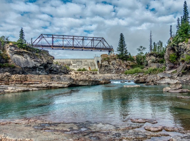
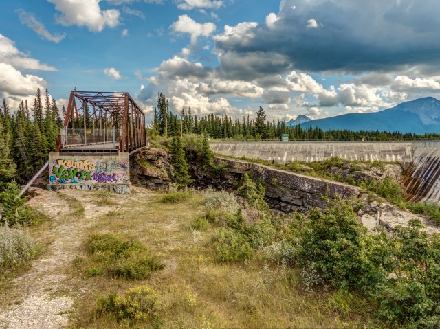
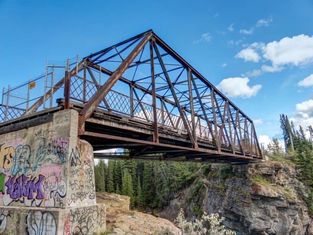
Just down stream from the dam is what we’ll call the spindly bridge. It’s a rather precariously placed structure that once supported the road that crews used to access the dam workings. The current alignment is to the west. The drop down from the deck to the river far below in a deep rock canyon is considerable. Today it’s used simply to support one small pipe. What that pipe carries is anyone’s guess. The bridge was built in a Pratt style, which may not look that substantial, but it’s quite a strong arrangement overall. This arrangement is probably one of the most common through-truss styles seen from the old days. It worked well for roads and in a more substantial form, railways.
From what we’ve been able to glean, the bridge was constructed in the 1920s. It’s not known if there was another such crossing here before or not, or perhaps another somewhere in the area. It would certainly be needed, I would think.
Anglers can often be seen in area. Cliff diving is also popular in here. Personally I think those who do that are some crazy folks. Every now and then, as happened this year, people die while participating in this activity.
Recall we mentioned another dam in the immediate area. It’s overall smaller in size but similar in appearance and is located a few kilometres downstream. This is the Horseshoe Dam which will be the subject of its own report (our hiking trail went right past it). I believe it and Seebe dam are operated as one unit.
At one time there was a small worker’s village nearby on the other side of the river. This was the town of Seebe, abandoned and torn down not that long ago (and I think where it was is on private property). It held the distinction of being the site of the very last one room school in the province.
During World War Two a POW internment camp was located nearby.
Over the years various movies were filmed in the area near the dams including Brokeback Mountain, Legends of the Fall, the River of No Return with the always amazing Marilyn Monroe, and others.
All the places seen in this report are publicly accessible.
To see pictures from our Bow Valley hike, follow this link… Horseshoe Canyon
To see more of the Horseshoe Dam, go here… Horseshoe Dam.
I was at Seebe damn a few days ago. The spindly bridge is gone. It has been replaced by a higher metal span carrying a new pipeline across the gorge. The graffiti-marked concrete bridge abutment is still there. The water was higher and flowing faster than when you took your pictures. A very spectacular site. Sadly, I didn’t take any pictures to post.
My family was one of the first in Seebe ,when my father was a boy he was in the film and on set for “The river of no return” if you saw an old pink cement house that was the one they built
We used to do something called the "pointless challenge" 🤪 and miss those days. It was so much silly fun and often frustrating as heck. In these we'd invite people to send in random photos of obscure locations, but not give any information, and then we'd track where it was and shoot something similar.
Most of these came from old family collections, as was the case here. Anyone up to resurrecting the series?
In hindsight, why didn't we pose someone in our shot?
Pointless: “Devoid of meaning (or) senseless” Merriam-Webster.
If you like what we do and want to support this ongoing project (12 years now), go here: https://www.BIGDoer.com/help-the-society/ Thanks to Connie for making this post possible.
Exploring history with Off the Beaten Path with Chris & Connie. Photo: ca1970 and 2014. Posted by Connie.
Captured on a cold, cold day many years ago. We've been passing this old house for decades and it's little changed in that time. At some point we expect to drive by and it'll be gone.
Exploring history with Off the Beaten Path with Chris & Connie. Photo: 2017. Posted by Connie.
When retired old railway cars usually get cut up for scrap. Sometimes, however, they find their way into the hands of the general public or whomever. Flat cars make good bridges, and boxcars can be transformed into storage buildings and the like. Case in point here. We see them used like this often enough and in this case, it's part of a corral.
Incidentally, this boxcar dates from 1950 and this was found by tracing the old road number, which is still visible.
Exploring history with Off the Beaten Path with Chris & Connie. Photo: 2017. Posted by Connie.
This central Alberta racetrack was never a commercial operation but instead just a fun place for car enthusiasts in the area to get together. Early '70s or thereabouts and it only lasted a few years. Even thought it's been abandoned for that long, there is no doubt what was here.
You know we like the the obscure stuff and this one fits the bill perfectly. Found by accident while backroad cruising and the history comes thanks to local car guy Mike.
Exploring history with Off the Beaten Path with Chris & Connie. Photo: 2022. Posted by Connie.
On top of little Myrtle Mountain in the Kimberley (BC) Nature Park.
There's some good wilderness fun to be had here and nice views as you can see, but the real reason we came is mining history. The whole area near the ski hill was extensively worked over a century ago and we were looking for evidence of this. We didn't find much in the area searched, but it's a big chunk of property and we hope to return to cover more ground again soon. Of all the subjects we cover, mining related is a favourite.
Still, it was a good hike and that can't be bad. Look to the comments for more info 👇.
Exploring nature and history with Off the Beaten Path with Chris & Connie. Photo: 2022. Posted by Connie.
It's a strange curiosity in south Kananaskis, there on a hillside and we have no idea who created it. We asked around and no one's completely sure about its history. In the past it showed the Canada 100 logo from 1967 but in 2017 someone changed it to reflect the country's 150th.
That's our friend Emily from DanOCan.com having a look.
Exploring history with Off the Beaten Path with Chris & Connie. Photo: 2017. Posted by Connie.
Javascript is required for this site to function. Please enable it in your browser settings and refresh this page.
Please log-in to continue... This allows unrestricted access to every post @BIGDoer.com, popups are eliminated, commenting is on and the "contact us" page is enabled.
Your social site may send you a routine notice of login.
Or signup, here: Subscriber Register ___ BIGDoer.com: Serving up POP HISTORY & other McFun!…(Mmmm, yummy bite-sized pieces.) One million plus words & tens of thousands of photos!


DO NOT GO! There is zero tolerance for trespassing and we all got $600 fines! This is Trans Alta property and only first nations are permitted.
On the time of our visit access was allowed on the north side, so not the road & train track side you’re referencing.
I was at Seebe damn a few days ago. The spindly bridge is gone. It has been replaced by a higher metal span carrying a new pipeline across the gorge. The graffiti-marked concrete bridge abutment is still there. The water was higher and flowing faster than when you took your pictures. A very spectacular site. Sadly, I didn’t take any pictures to post.
We had heard rumours it was gone, thanks for confirming. It was photogenic, but I guess a liability in some way and had to go. Thanks!
I love these colors!
For some reason they really pop in that area. No complaints here!
Just saw on facebook the bridge has been replaced.
Yikes, I saw that too. Glad we shot it when we did.
What amazing colours. Are they really like that or did you shop them?
They are that stunning in real life.
Amazing photos! I’ll be following your blog a lot. Thanks!
And be sure to comment a lot!
My family was one of the first in Seebe ,when my father was a boy he was in the film and on set for “The river of no return” if you saw an old pink cement house that was the one they built
Sorry for the delay. What a cool connection! We walked into one of the places seen in that movie.
My uncle worked for Alberta Power ans live in Seebe
We’re back! What a cool connection to a interesting little place.