An interesting way to spend an afternoon, BIGDoer.com connects up with a group of three travelling the globe on a lengthy and ambitious mission to document train stations…in a very interesting way. From the University of Rochester (New York), the trio have brought along some high-tech equipment which is used, specifically, to create a three dimensional digital model of their subject matter. Their goal in the end is to later draw up visual comparisons between similar structures from the countries they’ll visit.
Initial contact…
“For one week in mid-July, a professor of architectural history, a classmate, and I will be driving from Edmonton to Winnipeg on a grant-funded project to research—and use 3-D laser scanners to document—train stations built around the turn of the twentieth century…we hope to connect with local experts and rail enthusiasts in some of the cities and towns we will be visiting, who can serve as informants and/or accompany us to sites we will be photographing or laser scanning.”
↓ ↓ ↓ ↓ Scroll down for photos and to comment ↓ ↓ ↓ ↓
While their objective and even a basic understanding of what they’ll be doing seems pretty clear, the more complex and technical nature of the actual scan process is a bit of a mystery. Heck, yeah we’re curious and would both love to help and see how it’s done. Sign us up…well me up. Connie couldn’t make it, sadly.
The process being documented here is called Building Information Modeling or BIM. Ooooh, sounds tech! Simply, according to a committee whose purpose it is to set the standards, it’s defined thusly…
“Building Information Modeling (BIM) is a digital representation of physical and functional characteristics of a facility.”
Or dumbed down, use some equipment to make a cool 3D computer model of something. BIM for dummies (so us).
Spelling quandary: living in a Commonwealth country I guess we should use the British “double l” in the world modelling (< ---like that) instead of the "single l" as used in the US. Realized after writing this report, I did both! Was it a middle finger in the face of writing conventions or maybe just sloppy work? Modelling or modeling? Take your pick! I can't seem to decide.
Back on track…
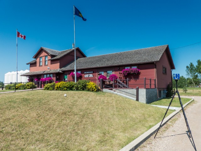
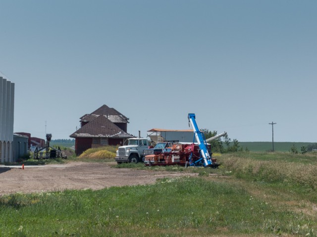
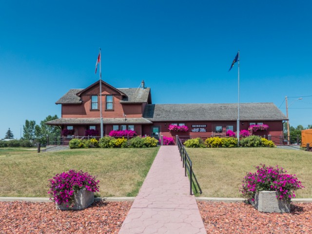
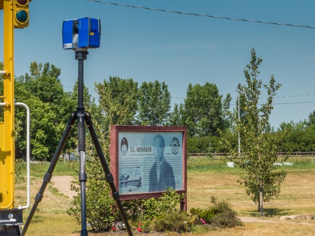
The subject for this scan is the old CPR train station in Beiseker Alberta. This century old structure, a fine looking one at that, is a pretty typical example of a standardized design used by that railway in that era. It’s sits only metres from where it was built, at the west end of “downtown” having only been moved back from from the roadbed a bit (track gone since the 1990s), and spun around one hundred an eighty degrees. Today it houses the town offices.
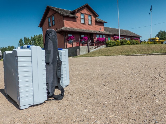
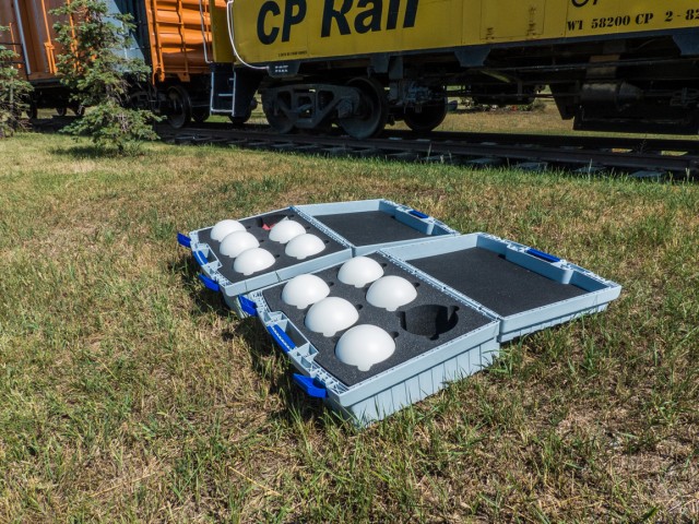
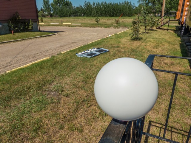
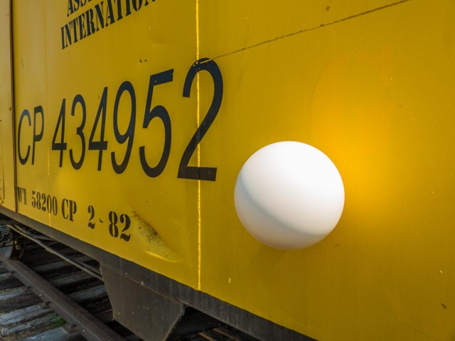
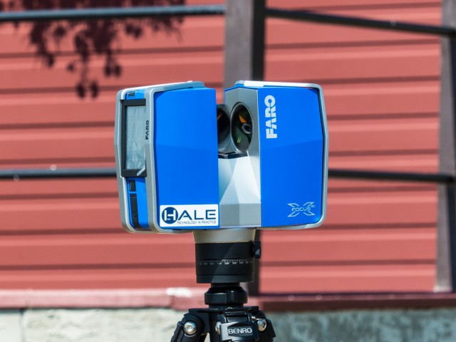
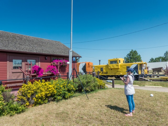
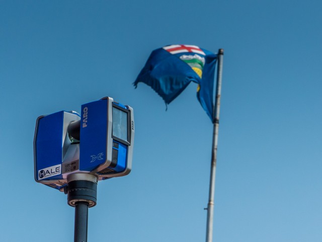
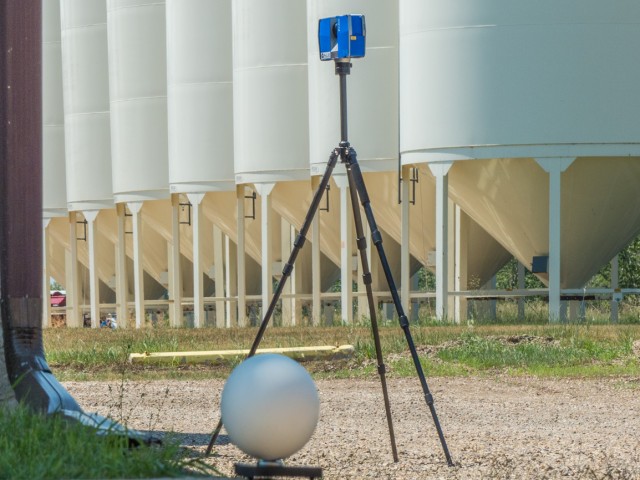
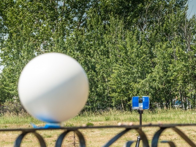
To make a scan requires several very expensive pieces of equipment. There is a large and very expensive camera, a substantial tripod to hold it steady when running and some volleyball-ished sized spheres. These latter are targets, placed around the scanning site here and there, which are used as reference points. They are simply laid on the ground, or attached to close-by elements, via clamps or if metal, with a magnetic base. The group used a nearby railway caboose, some poles, a fence…I think you get the idea. Nearly anything close by will do as long as it’s in clear sight of the camera, it just can’t be part of the building itself. I’m told these little white and shiny globes are worth a lot. Aaaah, special balls.
I questioned just how the group got this strange equipment through Canadian customs. Given the paranoid times, it must surely have raised suspicions. What the hell is it? Some type of subversive gear? Smart university types, they told me they made zero references to the word “laser” and instead referred to it as 3D surveying equipment. No “terrorist” words spoken, they told me everyone at the border was happy. I wonder how they did on the return trip?
The scanner is placed at various points around the building in a calculated fashion so it together covers (or can see) all possible facets. Per camera placement, and there are several, the camera takes in one flat wall or a 3/4 view, with lots of overlap between each. Every step is a five to ten minute process. The head moves around its axis, first quickly, then in slower more jerky fashion, an angled mirror spins and whirs the whole time, all sorts of noises are made and while we can’t see it in daylight, a beam is emitted, which is used to collect dimensional data. The latter “scan” happens one thin slice at a time countless times over.
Each occasion the camera is placed at a new location within the subject site, it needs to reference those balls we spoke of earlier – so a subsequent scan must see some referenced in the previous scan. Make sense? They’re used to triangulate positions.
Every tiny detail is recorded by this method (down to 2mm according to the manufacturer). The camera must not be subject to movement or even the slightest vibration when at work. Of course, no one must enter the field of view when a scan is happening either – a few were spoiled this way, but it is a town office after all and we fully expected people to come and go. No biggie, just try again.
Later, specialized software will be used to piece everything together creating a 3D photograph that can be viewed from any angle.
While the scan is taking place, the group jotted down notes and captured regular photographs. Huge amounts of data were collected and just processing it all is going to be a huge undertaking. The field work is only a small part of what they’ll do. There will be much time spent in the lab too.
We’re hoping to see the final product soon.
Earlier the same day, the group documented a similar station at Heritage Park in Calgary. After a bistro lunch in Beiseker (thanks guys, it was yummy), we parted ways, me heading back to BIGDoer HQ and them off capture more stations in other parts of the province. They had a LOT of places to scan and not much time to do it.
Beiseker is home to a second building like this, the old Bassano Railway Station brought in a few years back from its namesake town, a planned centrepiece of a museum that never really got off the ground. It was not scanned as it did not fit in with the plans the group had. They were looking for stations that were built to a more common pattern AND size – the Bassano one is HUGE and sort of a one-off in many ways.
Thanks to the UofR guys. It was a hoot and I learned something too! The group, Eitan, Alana and Peter were not only focused on the task at hand, but took time to have fun. That’s how we like it, we’re all comfy with each other. Those reference spheres inspired many ball-related quips and jokes, but I didn’t start them. Honest!
Love these types of outings. If you or your group need a guide or field crew to help with your historical-related work, sort of like what we did with this University of Rochester group here, be sure to email or message us. We’re happy to help. For museum, non-profits, historical societies and anyone else who’s doing it for the love, it’s done expenses only or more often than not, completely gratis.
(via Facebook) I don’t know how you could have explained this any better! Will pass this on when I’m at a loss for explaining what we’re doing with this project.
(via Facebook) Chris, you did a phenomenal job of explaining this very complicated technology! I’ll be sure to share this article with friends, family, and colleagues who are curious about the work Peter, Alana, and I are doing. I promise there’s plenty of great material to come from us—we’ve started the computer modeling process and have already gleaned some very cool images and spatial information from the data.
We used to do something called the "pointless challenge" 🤪 and miss those days. It was so much silly fun and often frustrating as heck. In these we'd invite people to send in random photos of obscure locations, but not give any information, and then we'd track where it was and shoot something similar.
Most of these came from old family collections, as was the case here. Anyone up to resurrecting the series?
In hindsight, why didn't we pose someone in our shot?
Pointless: “Devoid of meaning (or) senseless” Merriam-Webster.
If you like what we do and want to support this ongoing project (12 years now), go here: https://www.BIGDoer.com/help-the-society/ Thanks to Connie for making this post possible.
Exploring history with Off the Beaten Path with Chris & Connie. Photo: ca1970 and 2014. Posted by Connie.
Captured on a cold, cold day many years ago. We've been passing this old house for decades and it's little changed in that time. At some point we expect to drive by and it'll be gone.
Exploring history with Off the Beaten Path with Chris & Connie. Photo: 2017. Posted by Connie.
When retired old railway cars usually get cut up for scrap. Sometimes, however, they find their way into the hands of the general public or whomever. Flat cars make good bridges, and boxcars can be transformed into storage buildings and the like. Case in point here. We see them used like this often enough and in this case, it's part of a corral.
Incidentally, this boxcar dates from 1950 and this was found by tracing the old road number, which is still visible.
Exploring history with Off the Beaten Path with Chris & Connie. Photo: 2017. Posted by Connie.
This central Alberta racetrack was never a commercial operation but instead just a fun place for car enthusiasts in the area to get together. Early '70s or thereabouts and it only lasted a few years. Even thought it's been abandoned for that long, there is no doubt what was here.
You know we like the the obscure stuff and this one fits the bill perfectly. Found by accident while backroad cruising and the history comes thanks to local car guy Mike.
Exploring history with Off the Beaten Path with Chris & Connie. Photo: 2022. Posted by Connie.
On top of little Myrtle Mountain in the Kimberley (BC) Nature Park.
There's some good wilderness fun to be had here and nice views as you can see, but the real reason we came is mining history. The whole area near the ski hill was extensively worked over a century ago and we were looking for evidence of this. We didn't find much in the area searched, but it's a big chunk of property and we hope to return to cover more ground again soon. Of all the subjects we cover, mining related is a favourite.
Still, it was a good hike and that can't be bad. Look to the comments for more info 👇.
Exploring nature and history with Off the Beaten Path with Chris & Connie. Photo: 2022. Posted by Connie.
It's a strange curiosity in south Kananaskis, there on a hillside and we have no idea who created it. We asked around and no one's completely sure about its history. In the past it showed the Canada 100 logo from 1967 but in 2017 someone changed it to reflect the country's 150th.
That's our friend Emily from DanOCan.com having a look.
Exploring history with Off the Beaten Path with Chris & Connie. Photo: 2017. Posted by Connie.
Javascript is required for this site to function. Please enable it in your browser settings and refresh this page.
Please log-in to continue... This allows unrestricted access to every post @BIGDoer.com, popups are eliminated, commenting is on and the "contact us" page is enabled.
Your social site may send you a routine notice of login.
Or signup, here: Subscriber Register ___ BIGDoer.com: Serving up POP HISTORY & other McFun!…(Mmmm, yummy bite-sized pieces.) One million plus words & tens of thousands of photos!


I’m in the industry and you’ve explained the process well and so that it’s easy to understand. Good job!
Joss
JR Design 3D
You are most welcome. This was fun and learning experience and had a blast!
(via Facebook)
I don’t know how you could have explained this any better! Will pass this on when I’m at a loss for explaining what we’re doing with this project.
Thanks, I had a blast with you guys.
(via Facebook)
Chris, you did a phenomenal job of explaining this very complicated technology! I’ll be sure to share this article with friends, family, and colleagues who are curious about the work Peter, Alana, and I are doing. I promise there’s plenty of great material to come from us—we’ve started the computer modeling process and have already gleaned some very cool images and spatial information from the data.
Can’t wait to see them!
(via Facebook)
That is what I use at work BIM. Pretty neat!
Very cool!