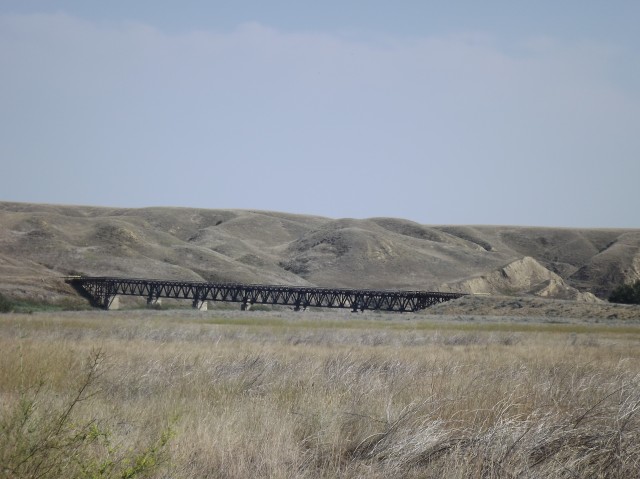
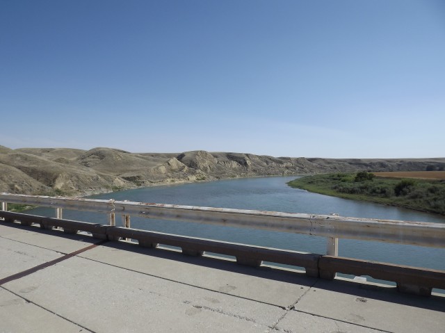
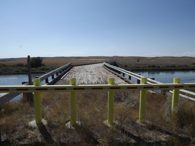
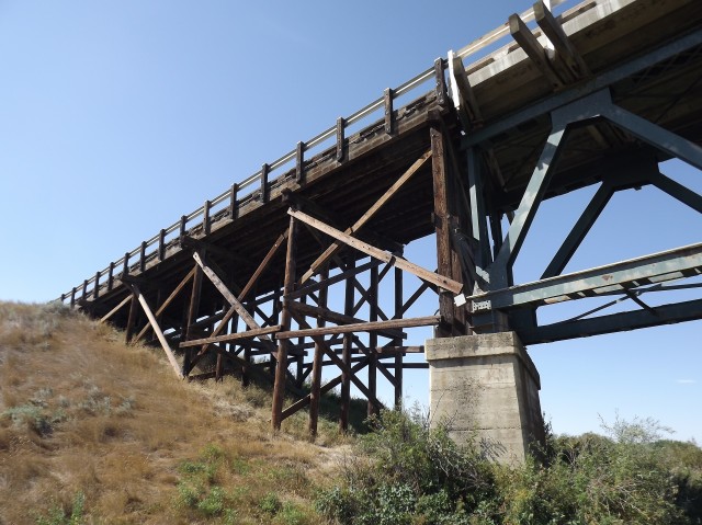
This abandoned bridge caught us by surprise. We were heading for another such structure in the area, the old CPR span over the Bow River near Cecil Alberta, when this one came into view. When heading north on Highway 524 near Hays Alberta, this structure can be clearly seen in the valley just east of the current river crossing.
Since the theme for the day was bridges, why not stop and take it in.
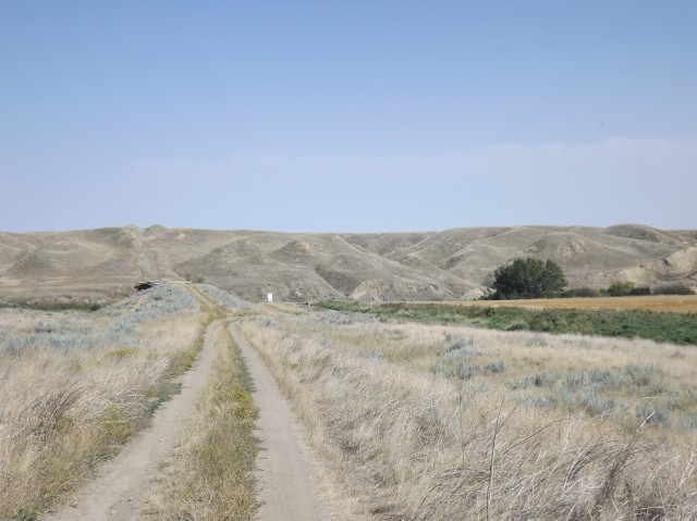
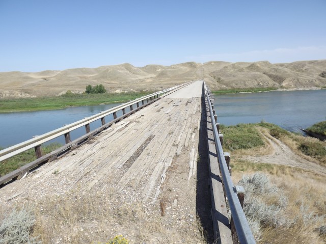
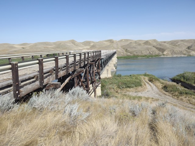
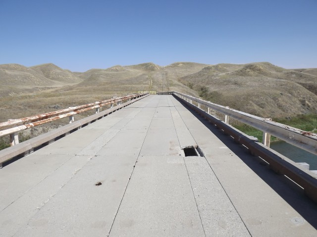
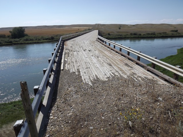
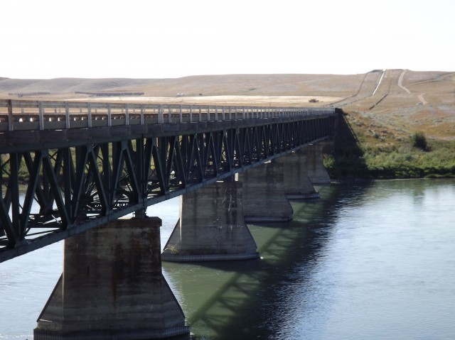
It’s an interesting structure, clearly well made and in good shape. But it’s narrow and has a wicked sharp turn off the north end, and the old approach roads from the prairies above are steep and winding. So while well constructed, all of this must have been a bit of a challenge to drivers, if not downright dangerous at times.
↓ ↓ ↓ ↓ Scroll down for photos and to comment ↓ ↓ ↓ ↓
I can see two cars approaching from opposite directions and the drivers wondering if they can fit past each other. And the odd bend in the north end of the bridge followed by a sharp turn on the road could catch you by surprise. To negotiate you’d have to slow down to a crawl. I can’t fathom what it was like in winter when the wind was howling and things were slippery.
I am sure everyone had a collective sign of relief when it was replaced with the current safer set up.
Bridges often have builders plates telling us the date they were made. I looked high and low and could not find one. Nor could I find any information much about it online, so for the time being anyway it’s lineage is a bit of a mystery (see updates).
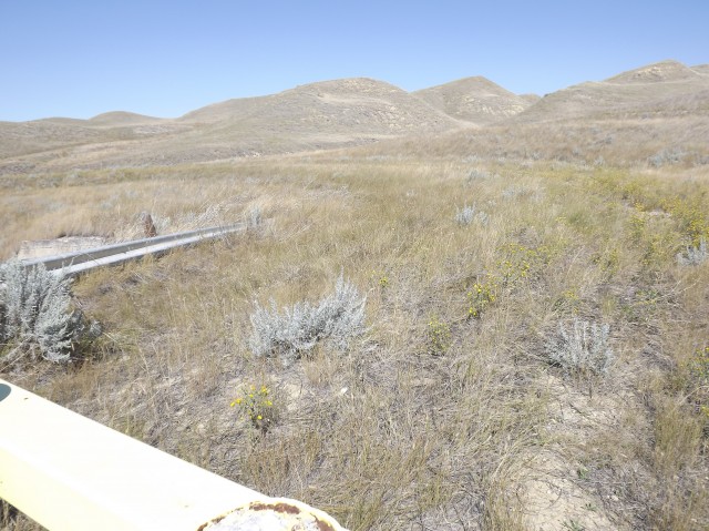
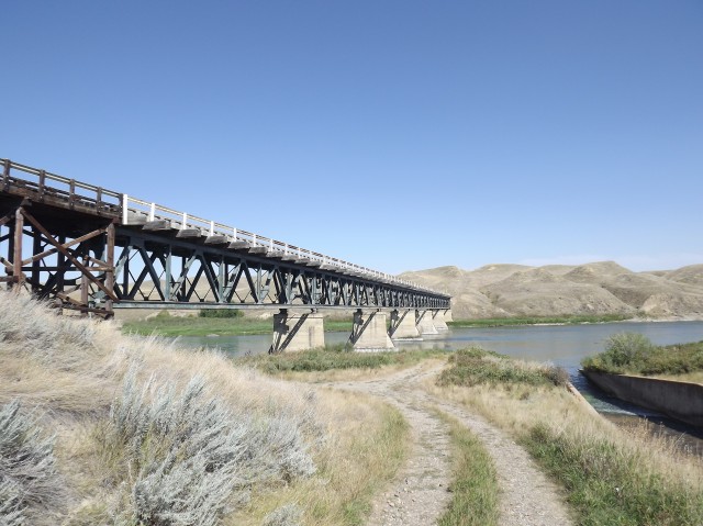
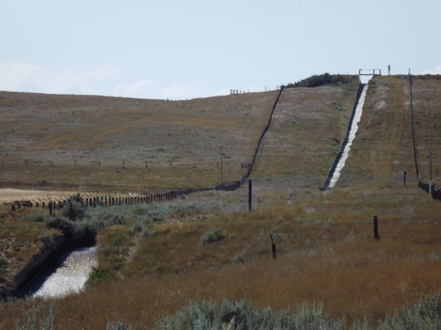
Just to the east of the bridge is an incredible water channel, a very steep concrete trough dropping down form the prairie above. This is a drain for one of the irrigation canals in the area. Not much would grow here if water was not brought in.
The area around the bridge is quite remote and supports a very small population and the whole time we explored the structure only a few cars passed on the other bridge. The valley was so quiet is was easy to hear them. Even on the plains above the valley, houses and farms are few and far between.
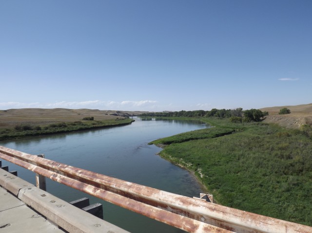
The Bow River here is wide and shallow and slow and it meanders through this wide valley taking it’s sweet time to where ever it’s going. The same river passes through the town I live in, Calgary. Even this far east the river is still crystal clear – prairie rivers are often muddy.
Update November 2012: A mystery uncovered. I have heard from multiple experts and it’s been confirmed that the bridge was originally to be used to support a syphon coming in from a nearby irrigation canal (built in the early 1910s). Initially I thought this was odd, but by going on Google Maps, an abandoned canal can be seen ending directly above the bridge on the north side. This old canal lines up perfectly with the in-use canal on the south side of the river with the bridge lying directly in between them.
With that in mind it’s then assumed that when the canal plans fell through the bridge was then converted to road use. The structure is pretty substantial, almost like a train bridge. If this syphon was built, it certainly would have been an engineering marvel and the drop down from the plains above is quite substantial.
Be sure to comment on this post (below pictures).
The old canal mentioned can be followed for may dozens of kilometres, ending near Suffield Alberta. Clearly it was well built but never used.
Update January 2013: This author has seen a picture dated 1915 that shows this same bridge looking very much as it does today. This date would tend to further support the bridge being built around the time of the canal and that its original purpose was to carry that syphon spoken about earlier. The dates, its location, it all seems to fit.
At the time of that 1915 photograph the bridge was already being used for vehicular traffic, the syphon having never been built. The whole irrigation project north of the bridge was abandoned the year before.
For our report on the nearby abandoned CPR Suffield Subdivision bridge over the Bow River, follow this link… Abandoned CPR Bow River bridge.
Possible I could have missed it but it would be great if you could provide geographical coordinates of these places so others can experience it. Thanks 🙂
One this post, yes you missed it. But it can vary for others. See the FAQ for more detailed info. Many of these places are on private property. Also they can be under huge threat from vandals and thieves, so sharing locations can lead to trouble. We’ve seen pristine places stripped bare and trashed within weeks once the location has been outed.
Can you imagine driving along this bridge! what an experience that would have been. There is a bridge near where I live, called the Black Bridge in Topsham ME, that used to have a road deck under the rail deck and had similar sharp corners on both approaches.
It’s so narrow and that sharp bend at the one end. Yes sir, it’d be an adventure crossing it, doubly so in winter. Looked up that one you mentioned – very cool. The road was clearly an afterthought.
The canal from this area to Suffield was built by horse power. Teams of horses pulling scrappers. The same crews also built rail beds. My Great uncle worked on some of these projects. The canal was never used due to both money problems and due to a survey error. The canal in the Suffield area area was something like a foot too high, so water would never run the length of the canal.
Also, remember in the mid 1950s traveling through the area, Hays, Tilley, Suffield seeing the canal. When the section roads were built, they simply bulldozed the banks of the canal in and built the road across it.
I’ve heard many reasons why the canal was never used. What you said and many others. Was it doomed from the start, was it just bad management, money problems? All or some? That’s open to debate.
Just wanted to say I really enjoy reading your site. Your post inspired me to stop at the abandoned Highway 524 road bridge near Hays in September of this year. I thought it was a site well worth seeing. I have nothing to add to the history that you found out. I took some photos and have encouraged some friends to check out some stuff off the beaten path.
When I lived in Vauxhall in the early 90s we would use this backroad as our way of traveling to Medicine Hat versus going down Highway 36 to Highway 3 and then across. I have great memories of spotting this bridge for the first time and it quickly became one of my favorite places. I drove across it many times before the road was realigned.
I’m impressed, this post and your blog as a whole is both informative and entertaining. You have hit the nail on the head, this is a great article. I’m very happy that I stumbled across this during my hunt for something relating to this – I was looking for information on failed irrigation projects in Western Canada. This bridge is a fascinating piece of that history.
I have not confirmed it but it sounds like the money ran out – I am still researching though. There is an in-use canal on the south side and it simply empties into the river right beside the bridge. That section was to be connected to the other part on the north side that was built but never used. It’s easy to trace that portion of it all the way from the bridge to a point on the Trans Canada highway half way between Suffield and Medicine Hat. It’s 40-50km as the crow flies between those two places. The canal snakes so much though that if stretched out it must be four or five times that in length.
I believe this bridge was constructed originally to carry a water siphon from the canal on the east side to the abandoned canal system that seems to end north of Redcliff. Possibly around 1912
That seems to make a lot of sense – on Google Maps I see an old and unused canal that ends on the hill directly above the bridge on the north side. It lines up perfectly with the other canal on the south side and it’s easy to see how the whole thing could be tied together. If completed this would have certainly been one of the largest siphons around. I can’t imagine the cost and manpower that would be required to make it. Thank you so much for your input!
We used to do something called the "pointless challenge" 🤪 and miss those days. It was so much silly fun and often frustrating as heck. In these we'd invite people to send in random photos of obscure locations, but not give any information, and then we'd track where it was and shoot something similar.
Most of these came from old family collections, as was the case here. Anyone up to resurrecting the series?
In hindsight, why didn't we pose someone in our shot?
Pointless: “Devoid of meaning (or) senseless” Merriam-Webster.
If you like what we do and want to support this ongoing project (12 years now), go here: https://www.BIGDoer.com/help-the-society/ Thanks to Connie for making this post possible.
Exploring history with Off the Beaten Path with Chris & Connie. Photo: ca1970 and 2014. Posted by Connie.
Captured on a cold, cold day many years ago. We've been passing this old house for decades and it's little changed in that time. At some point we expect to drive by and it'll be gone.
Exploring history with Off the Beaten Path with Chris & Connie. Photo: 2017. Posted by Connie.
When retired old railway cars usually get cut up for scrap. Sometimes, however, they find their way into the hands of the general public or whomever. Flat cars make good bridges, and boxcars can be transformed into storage buildings and the like. Case in point here. We see them used like this often enough and in this case, it's part of a corral.
Incidentally, this boxcar dates from 1950 and this was found by tracing the old road number, which is still visible.
Exploring history with Off the Beaten Path with Chris & Connie. Photo: 2017. Posted by Connie.
This central Alberta racetrack was never a commercial operation but instead just a fun place for car enthusiasts in the area to get together. Early '70s or thereabouts and it only lasted a few years. Even thought it's been abandoned for that long, there is no doubt what was here.
You know we like the the obscure stuff and this one fits the bill perfectly. Found by accident while backroad cruising and the history comes thanks to local car guy Mike.
Exploring history with Off the Beaten Path with Chris & Connie. Photo: 2022. Posted by Connie.
On top of little Myrtle Mountain in the Kimberley (BC) Nature Park.
There's some good wilderness fun to be had here and nice views as you can see, but the real reason we came is mining history. The whole area near the ski hill was extensively worked over a century ago and we were looking for evidence of this. We didn't find much in the area searched, but it's a big chunk of property and we hope to return to cover more ground again soon. Of all the subjects we cover, mining related is a favourite.
Still, it was a good hike and that can't be bad. Look to the comments for more info 👇.
Exploring nature and history with Off the Beaten Path with Chris & Connie. Photo: 2022. Posted by Connie.
It's a strange curiosity in south Kananaskis, there on a hillside and we have no idea who created it. We asked around and no one's completely sure about its history. In the past it showed the Canada 100 logo from 1967 but in 2017 someone changed it to reflect the country's 150th.
That's our friend Emily from DanOCan.com having a look.
Exploring history with Off the Beaten Path with Chris & Connie. Photo: 2017. Posted by Connie.
Javascript is required for this site to function. Please enable it in your browser settings and refresh this page.
Please log-in to continue... This allows unrestricted access to every post @BIGDoer.com, popups are eliminated, commenting is on and the "contact us" page is enabled.
Your social site may send you a routine notice of login.
Or signup, here: Subscriber Register ___ BIGDoer.com: Serving up POP HISTORY & other McFun!…(Mmmm, yummy bite-sized pieces.) One million plus words & tens of thousands of photos!


")


Possible I could have missed it but it would be great if you could provide geographical coordinates of these places so others can experience it. Thanks 🙂
One this post, yes you missed it. But it can vary for others. See the FAQ for more detailed info. Many of these places are on private property. Also they can be under huge threat from vandals and thieves, so sharing locations can lead to trouble. We’ve seen pristine places stripped bare and trashed within weeks once the location has been outed.
Can you imagine driving along this bridge! what an experience that would have been. There is a bridge near where I live, called the Black Bridge in Topsham ME, that used to have a road deck under the rail deck and had similar sharp corners on both approaches.
It’s so narrow and that sharp bend at the one end. Yes sir, it’d be an adventure crossing it, doubly so in winter. Looked up that one you mentioned – very cool. The road was clearly an afterthought.
The canal from this area to Suffield was built by horse power. Teams of horses pulling scrappers. The same crews also built rail beds. My Great uncle worked on some of these projects. The canal was never used due to both money problems and due to a survey error. The canal in the Suffield area area was something like a foot too high, so water would never run the length of the canal.
Also, remember in the mid 1950s traveling through the area, Hays, Tilley, Suffield seeing the canal. When the section roads were built, they simply bulldozed the banks of the canal in and built the road across it.
I noticed that too. Very interesting!
I’ve heard many reasons why the canal was never used. What you said and many others. Was it doomed from the start, was it just bad management, money problems? All or some? That’s open to debate.
Do you or anyone know when the highway bridge burned down at Ronalane? My dad was the section foreman for CPR and it was in the mid 50’s
Yes, sometime in 1956. You can read more on it here…
https://www.bigdoer.com/21851/exploring-history/wet-dreams/
Just wanted to say I really enjoy reading your site. Your post inspired me to stop at the abandoned Highway 524 road bridge near Hays in September of this year. I thought it was a site well worth seeing. I have nothing to add to the history that you found out. I took some photos and have encouraged some friends to check out some stuff off the beaten path.
Glad we inspired you!
When was the road realigned?
I’ve not been able to find out so far, but the replacement bridge appears quite new in comparison. Perhaps is was done within the last couple decades?
When I lived in Vauxhall in the early 90s we would use this backroad as our way of traveling to Medicine Hat versus going down Highway 36 to Highway 3 and then across. I have great memories of spotting this bridge for the first time and it quickly became one of my favorite places. I drove across it many times before the road was realigned.
Awesome I would have loved to have drive across it. That sharp bend on the north side is something else.
I’m impressed, this post and your blog as a whole is both informative and entertaining. You have hit the nail on the head, this is a great article. I’m very happy that I stumbled across this during my hunt for something relating to this – I was looking for information on failed irrigation projects in Western Canada. This bridge is a fascinating piece of that history.
We had a great time reserching and writing this article.
Bridge in nowhere…wow
Great photo’s Chris, do you know the story as to why the canal was never used?
I have not confirmed it but it sounds like the money ran out – I am still researching though. There is an in-use canal on the south side and it simply empties into the river right beside the bridge. That section was to be connected to the other part on the north side that was built but never used. It’s easy to trace that portion of it all the way from the bridge to a point on the Trans Canada highway half way between Suffield and Medicine Hat. It’s 40-50km as the crow flies between those two places. The canal snakes so much though that if stretched out it must be four or five times that in length.
This Link may help explain what went on here. forgottenalberta.com/2010/07/12/the-alberta-land-company/ (broken link)
Thank you, that link was very helpful!
I believe this bridge was constructed originally to carry a water siphon from the canal on the east side to the abandoned canal system that seems to end north of Redcliff. Possibly around 1912
That seems to make a lot of sense – on Google Maps I see an old and unused canal that ends on the hill directly above the bridge on the north side. It lines up perfectly with the other canal on the south side and it’s easy to see how the whole thing could be tied together. If completed this would have certainly been one of the largest siphons around. I can’t imagine the cost and manpower that would be required to make it. Thank you so much for your input!