
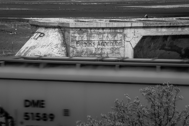
Brooks Aqueduct
It’s a marvel of engineering, a multi-kilometre long concrete structure a century old. Towering over the lone prairie it once brought life giving water to this parched region of Alberta, but today is unused. It was replaced – everything and everybody has that fate eventually – but stands as a monument to the challenges facing those who live farm in the area. Water meant survival then and it’s no different today. We’re talking about the Brooks Aqueduct, just outside Brooks Alberta (who’d have thunk) and we’re inviting you to come along with us and take a tour.
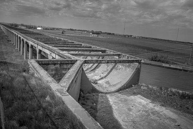
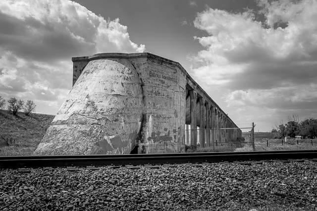
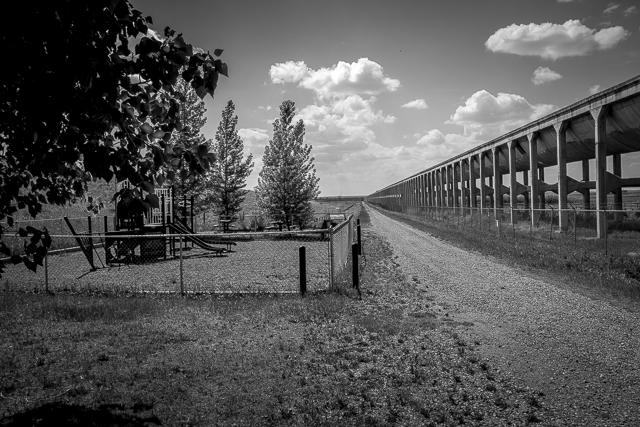
The Aqueduct was part of the Eastern Irrigation District system. Think of it as a bridge for water taking it over a low lying section of land and at each end it would reconnect with the earthen canal. When built it was just over three kilometres long but is a bit shorter today with a centre section having been removed a few decades ago so a road could be punched though. This gap, however, affords a good cutaway view of how it was constructed especially from that road which is elevated to pass over the newer canal.
Constructed between the years 1912-1914 it took some 19000 cubic metres of cast concrete and 1800 tonnes of reinforcing steel to complete. This was cutting edge tech for the day and at the time of of its completion was the largest or one of the largest concrete structures (depending on the source) on the entire planet. Either way, it’s unarguably massive and no less a wonder today then it was back when built. People stop and look in awe. Old photos taken while it was under construction show many men and horse teams working there.
The piers, over five hundred cross-braced pairs in total and of varying height depending on the lay of the land, support an underslung round bottom trough or flume designed with a smooth flow in mind. The grade is modest, perhaps a couple percent or so at the most (only hinted at) and the flow would have been some twenty five cubic metres per second. Joints made of corrugated metal, placed every so often allowed for expansion, for without, the structure would have soon torn it self apart on account of temperature changes. Smart guys those engineers. Water only flowed during the growing season with the system being empty at other times.
Originally built and owned by the Canadian Pacific Railway it was acquired by the “EID” in the mid-’30s. Prior, the region was rather sparsely populated due to dry conditions but afterwards settlers flocked to Brooks and surrounding towns, some newly incorporated, with many farms being established nearby. Many of these are still here today and continue to use the water brought in. In total the canal provides irrigation to some hundred and ten thousand plus hectares of land, or the size of a fair city (Vancouver is close).
An interesting feature of the Aqueduct is the syphon taking water down and under the CPR tracks and then back up again. It’s simply a large pipe that even with that dip allows the water to flow unassisted – the downstream end need only be slightly lower for it to all work. Amazing really. The current canal, just to the east of the Brooks Aqueduct, has a similar syphon going under the tracks. You can see the outflow end in one photo. Old pictures found while researching this piece show people frolicking in the Aqueduct – hopefully on the down side of the syphon.
The Aqueduct required yearly maintenance in the off season with vegetation and debris being removed and a general inspection following. The structure was rehabilitated a number of times over the years. A particular problem was cement spalling (flaking off). The materials and techniques used back then were not anywhere near as good as today and freeze and thaw cycles in particular could readily damage it. Even today one can see where patches were made.
The structure was used up until the 1979 season. By this point it was beyond repair economically, however, with a new elevated canal being built right beside and replacing it. This berm affords one a nice elevated look at the old Aqueduct. Deemed too expensive to raze, the structure was kept in place and fenced off. You don’t want people climbing all over it after all. Or chunks falling on someone’s head.
The canal, incidentally, is fed from the Bow River near the town of Bassano (west), via Lake Newell, a reservoir (south). It then continues north for a fair distance. If you look on Google Earth you can see the many circular irrigated fields, all bright green, fed by the system. Land not irrigated is unproductive for crop production and generally used for pasture.
The Brooks Aqueduct is historically recognized, since around 2000. There’s plaques and a kiosk on site. In the past we understand there used to be human interpreters stationed here.
The CPR’s mainline splits the Aqueduct at the syphon with many trains passing each day. We saw three in an hour or so. You have a nice view of the tracks from the new canal. Just don’t fall in the water! Trains? Historical stuff as a backdrop? Win-win in our book. The railway, by the way, came through here in the 1880s. Brooks, a town of some fifteen thousand, can be seen off there in west a few clicks away. When the Aqueduct was built it was home to a few hundred people.
That “aroma” on the air is a huge cattle processing plant not far away. In the 1990s your author hauled pipe into the plant and the sheer size of it, and the stink, was incredible.
From the area…
Scandia Eastern Irrigation District Museum.
Fossil Prospecting @ Dino Provincial Park.
Shoulder Season @ Dino Provincial Park.
Industrial Works Dragline.
If you wish more information on what you’ve seen here, by all means contact us!
Date: June, 2018.
Location: Just outside Brooks Alberta.
Article references and thanks: Eastern Irrigation District – Aqueduct.Eidnet.ca, HistoricPlaces.ca.
All shots were taken from public property.
At the Brooks Aqueduct, Brooks Alberta.
It was in use for over 60 years – water exited into a canal here.
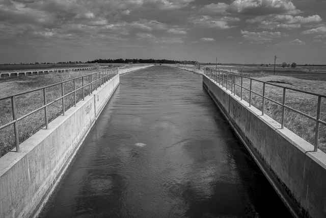
What replaced the Aqueduct.
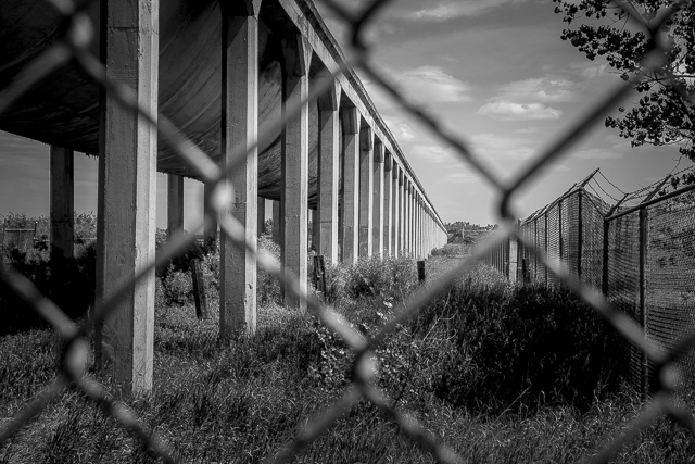
It extends for many kilometres.
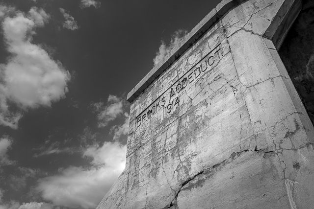
Built 1914.
Syphon drops under the tracks.
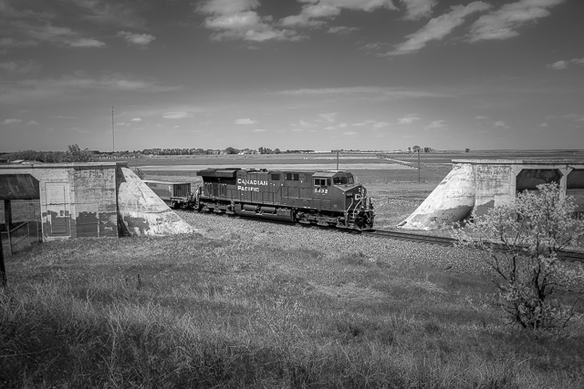
A great train spotting location.
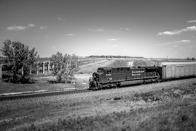
And another passes – we could do this all day.
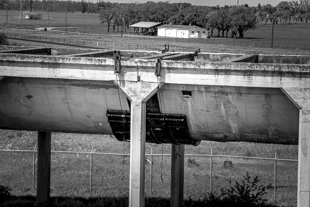
A brace reinforces a corrugated expansion joint.
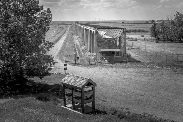
A section was removed so a road could be built.

What a marvel of engineering.
And it’s been historically recognized.


I was there this past summer of 2019. It’s quite a site. I somehow missed seeing the syphon but you got an excellent photo of it in this blog. I think someday you should put all this together in the form of a coffee table book.
It’s an awesome piece of engineering. It’s easy to miss the syphon as it’s away from the day use area. We’ve been approached to do a book more than once, including just this week, but humble us (which will be our downfall) feels it’s undeserving. Maybe we’ll relent to the pressure. Thanks for commenting!
Stopped there on the weekend – I had originally planned on photographing the CP Holiday Train at that location as it was approaching Brooks, but we didn’t get to the Aquedect in time. I do plan on returning next spring to check it out closer in detail though!
It’s an amazing structure and one so photogenic. Already I want to go back. Ooooh, that would have been cool to catch the Xmas train there. Too bad!
Thanks for this. An interesting piece of infrastructure.
You are most welcome. It is so historic and the engineering and work that went into it, wow!
Used to swim in there when we were kids.
And that’s not dangerous at all! We’ve heard from a few locals who used to do it as well, as fearless kids, and it’s a wonder any of you made it to adulthood! Say that of myself too.
you guys find the coolest stuff!
We’re so blessed to be able to explore all these amazing places. And we’re having a blast!
This brings back the memories of the winter of 1986/87 where fresh out of high school I had my first taste of management and responsibility; myself and a crew of 2 built the 10km of chain link fence you see in all your photos for the sub-contactor who secured the Gov’t of Canada contract. When talking to some of the locals the story started to emerge of why the fence was so important. Mostly it was to protect people from the structure and not the other way around… one gentlemen told me of how he would drive his dirt bike along the ledge of the aquaduct or use the interior as a half pipe trying to get as close as he could to the cross bracing with his shoulder. Another talked about how he would take his old Duster and try to race down the inside, quite a feat considering how uneven the inside was even then. The Brooks Pheasant Hatchery which closed in 2013 was located about 2 kilometers away. The birds were so tame, they would walk up to me looking for food while I was trying to work. In third to last photo, along the roadway about the middle view, while following one of my crew, he kicked at something on the road and mentioned a ‘bottlecap’ as he passed over it. I stopped to pick it up since it looked like a quarter. I was quite surprised that I had found a penny from 1910, presumably lost by one of the workers during the time of construction.
This is epic! What an amazing connection to the place. I heard stories about people swimming in the Aqueduct, but cars and cycles?* How’s that even possible? Amazing! And finding an old coin – that’s the stuff of memories. Thanks for sharing them all with us! (*In the off season, the structure was drained of water).
I thoroughly enjoy your posts.
That makes us so happy! We do it for you.
That’s a great shot! love the perspective (of the train splitting the Aqueduct).
That one worked out well. Thanks for the love.
Fascinating stuff–wow. Appreciate all the detail on this page.
Love what we do, and I think it shows. Without a some history it’s not the same. And anyway our photos are not strong enough to tell a story in themselves. We’re hacks in that department. Haha!
Great shots Chris!
We’re so happy to hear that. Thanks!
That is really neat. Thank you!
It sure is! And you are most welcome.
Wikpedia reference to bow River and the dam as water source.
Yes, as mentioned. The canal sure winds its way across the countryside, which is really interesting. Not many straight sections.
A few of us locals were filming out there, some footage for the Brooks Museum…. I was a railway boss, then a news reporter (huge stretch, given my past!). Was especially cool to film by the siphon!
That’s awesome Ryan! I’d love to do the period costume thing for a shoot sometime.
I remembering being there in 1979 when it was still full of water. It was something to see. Posted photos of it (on Facebook) earlier.
Thank you, we’ll go looking for those pics!
Oh ,50 years ago I railed to Brandon and back to Calgary Might have been this track Can’t say I recognize this local though.
Then you’d have passed the Aqueduct by. For sure. You must have missed seeing it though.
The Brooks Aqueduct is a great place to visit along with Dinosaur Provincial Park.
Yes, yes it is!
See:
https://www.bigdoer.com/35171/other-fun/shoulder-season-dino-provincial-park/
and
https://www.bigdoer.com/35286/other-fun/fossil-prospecting-dino-provincial-park/