There’s a huge number of abandoned railways in Canada, thousands and thousands of kilometres worth. Only upon looking at old maps does it become clear just how extensive the network was. These disused lines are particularly common in the grain growing regions of the west but can be found across the country. With few exceptions, it’s loss of traffic that forced their closure. On this happening the railway typically removed infrastructure, with only the old roadbed earthworks remaining, a final reminder of what was.
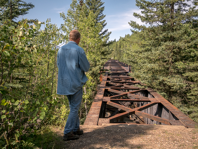
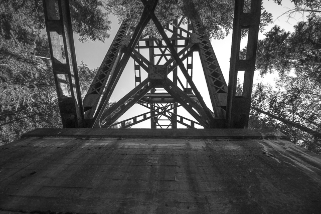
Here’s something pretty interesting, not accidentally forgotten when they pulled out, but left in place because it was simply too costly to remove. That’s one big hunk of metal! Here’s the Taunton/Fortner Train Bridge in the Alberta Foothills, along Canadian National Railway’s former Brazeau Subdivision. They removed the deck to keep people off, but otherwise, it stands where built, as built and given its robust construction is likely to remain long after we’re gone. The railways seemed to always overbuild things like this.
Taunton/Fortner Bridge: abandoned in woods. Not crossing over with Chris Doering & Connie Biggart (BIGDoer/Synd/Canada.com)
If plans work out, and they’ve been at it for a time, the bridge will be re-decked and incorporated into the Nordegg to Rocky Mountain House Rail Trail. Some parts of this recreation route have already been set aside and are in use officially, where as others have not, but are still passable. The bridge is along the latter section. Further up and down the line in the area are a number of wood trestles removed when the salvage crews moved in. There’s many gaps to be filled.
Scroll down for photos and to comment.
The Taunton/Fortner Bridge was named for the creek that runs far below. It’s a rather insignificant little watercourse, but the gorge it made is quite deep (hard to tell with all the growth today). It’s had two names over the years, present Taunton and former Fortner. The origins of both monikers appears to be unknown and exactly when the change happened equally a mystery.
The Brazeau Subdivision dates from the 1910s and was built by the Canadian Northern Railway, under the Canadian Northern Western Lines charter (a paper railway). The Canadian Northern was a transcontinental that had track going every which way in the west and fingers in a lot of pies. Always on shaky ground financially, this firm and some competitors were folded into Canadian National Railways by the early 1920s. On the east end of the Brazeau line grain made up most of the business but once into the foothills, coal was king. Lots of it moved from mines in Nordegg, plus nearby Alexo and Saunders.
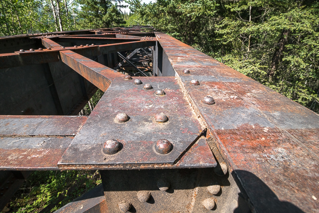
The bridge dates from the early 1930s and is of riveted steel construction. It replaced an earlier wooden structure dating from the line’s opening and simply massive in size (we’ve seen pics). Construction of this new span was approved before the great crash of 1929 and no doubt the money outlay was a sore spot for the CNR with the realities of the great depression setting in. By the time finished, traffic and income was way down. Later the investment would pay off and during World War Two freight moments on the line would be at an all time high.
To expedite a seamless transition, the old bridge remained in use till the present one was completed. This required a little bit of rerouting and today one can see remains of the original roadbed leading to the the first span, to the left. We looked for evidence of the wood trestle, but found nothing conclusive – just a steep drop off.
The coal mines lasted into the mid-1950s, when failing demand caused their closure. With that, traffic along this section of line fell off precipitously. For a time there was was only sporadic movements of “wood products” (logs headed to Rocky is suggested) lasting into the late 1950s/early 1960s period (some conflicting data). Afterwards, the line was “mothballed” and not officially abandoned, perhaps being held should coal markets rebound.
In the meantime, most of the the eastern section of this line remained in use and today serves a number of petroleum plants.
It’s believed the track along this western section was not removed on closing and maybe have remained in place into the 1980s. By the middle of that decade, the line was officially abandoned and a few years later removed completely (if not done already). By then, it had been eons since the train last passed. Interestingly, we saw remains of a fairly “modern” CN sign warning of hazards along the stretch of track by the bridge.
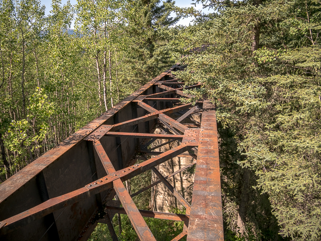
The forest has since grown in thick around the bridge. We’ve seen photos showing it being built and the area appears devoid of forests (a fire earlier?). Only then can you truly gauge the size of the current structure. It’s massive with big concrete piers supporting the steel work. The bridge is a mix of plate girder spans and sections with an under deck truss. It must be quite the view from the centre – and given there’s no “sides” to the bridge, quite unnerving for anyone no fan of heights. If they re-deck it, of course, there will be a protective fence put in place. Crazy as it seems, we’re heard of a couple people walking out of the structure while balancing on a support beam.
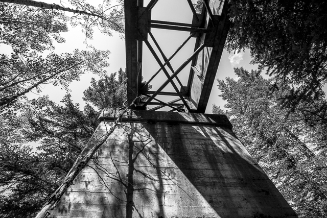
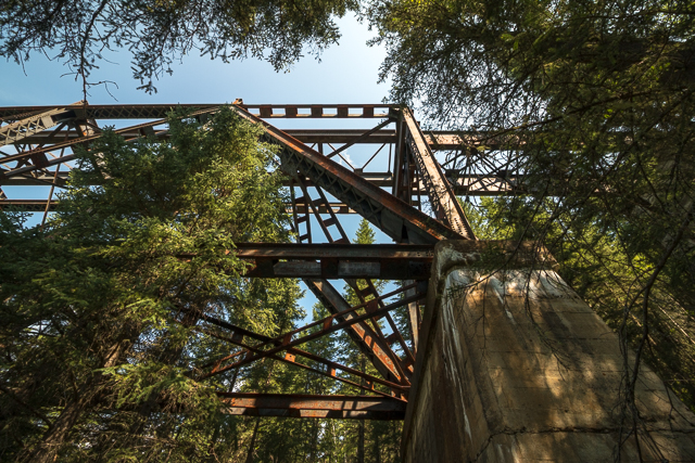
We clamber down to look at the piers. Sometimes the date is cast into them but not so on this end at least. Maybe on the (unreachable to us) west end? Still, we get to see how they built these huge masses of cement using a board by board form. The imprint of each plank is mirrored in the concrete.
Not that we’re bridge engineers in anyway (but play one on TV), everything below looked solid with no signs of shifting or movement. After the second pier, it’s steep drop down to the (unseen) creek. The trees in the gorge have grown so tall they’re tickling the underside of the structure. If they do succeed in making an official trail of this section (and it’s not as simple as it sounds), we suspect they’ll cut back the forest crowding the bridge.
There’s a wall of ties before the structure blocking vehicles from venturing any closer (which could be disastrous). “Zooming along…here, hold my coffee…what’s that over there….brakes….ahhhhhhh!” And they were seen again.
Our host this adventure is someone who for regular readers of this website needs little introduction, B&W film photographer Rob Pohl. He’s that fellow with that big view camera you see from time to time here. And to think he schlepped his heavy rig (must be 20-30kg easy) the five click round trip it took us to get here. In the stifling humidity, under a merciless sun. Hard core dude!
To see grain elevator remains that once stood along this same line, on the also abandoned far eastern (prairie) section, see: Prairie Sentinels – Oberlin Alberta
Till the next post, keep curious!
They’re saying…
”Love the stories, love the history and appreciate the effort to document both in words and pictures before it’s all gone – or maybe to help keep it alive!” Kathleen Raines.
If you wish more information on what you’ve seen here, by all means contact us!
Date of Adventure: August, 2019. Location(s): Clearwater County, AB. Article references and thanks: Glenbow Photo Archives/Glenbow Western Research Centre, Canadian National Railway Timetables, Alberta Energy Regulator Coal Mine Records. Please show caution should you visit the bridge – it’s dangerous!
Yes… we will have to try to get over to the other end of the bridge next time, and see if the view is a little less obscured. That tunnel sounds cool too… I found the “Baby Cemetery” last time I was out there. Its just a short walk off the road.
Wow, thank you for taking the time to go exploring and take all these photos. I had heard of this bridge, but had no idea it was so big!
I wonder if the steel was obtained from another bridge on a line that had been abandoned, as happened with this bridge just east of Red Deer. The steel came from Canadian Northern’s McLeod River bridge at Tollerton, just south of Edson, AB, on a section of their transcontinental line that was abandoned after the Canadian National merger.
railpictures.ca/?attachment_id=24087 (copy & paste into browser window)
I believe the CNoR’s Pembina River bridge at Evansburg, AB met the same fate, though I cannot recall where its steel ended up.
It was very difficult for CN and CP to officially abandon lines before being deregulated in the late 1980s, and it was easier for the railways to simply cease operating trains and maintaining the track on lines without customers. The west end of the Brazeau Sub was just one of many lines that went decades without a train before being officially abandoned. Note footnote 2.3 in this 1970s-era timetable:
cwrailway.ca/cnrha.ca/Timetables/Mountain%20Region/Alberta%20South%20Division/Brazeau.pdf (copy & paste into browser window)
We love to share! We couldn’t find a backstory in regards to the origins of the bridge, be it a new build or one recycled. It’s completely possible it was the latter, given the frugal nature of railways. We did find some old photos of it being erected on site, but they offered no real insight. Thanks for sharing the timetable. While regulatory hurdles makes complete sense, still we can’t help think hopes of the coal market rebounding might have also influenced the decision to not officially abandon the line. Our research shows lots of (good) coal still left in the area and one old paper we found even hinted of a new mine opening (1970s era). Either way, the tracks remained for some time.
There is a current proposal for a new metallurgical coal mine about 26 km southeast of Nordegg:
ramcoal.com/aries-project
Their construction would not involve any rebuilding of the abandoned portion of the Brazeau Sub, rather a new 28 km spur off CN’s Ram River Sub, starting at or near the junction with the Strachan gas plant’s spur. This next link contains a map on one of the final pages:
There is a massive amount of high-quality coal along the east slope of the Alberta Rocky Mountains. The seams run parallel to the mountains, and have been mined at Tumbler Ridge, Grande Cache, Hinton, the Alberta Coal Branch, Nordegg, Canmore, and in the Crowsnest Pass.
The seam that was mined at Nordegg and is still mined at Coal Valley provided some of the best locomotive coal in western Canada. It is a hard coal with a high heating value and low ash content, ideal for grate firing.
Prairie coal is more chalky and has a higher ash content, which means a locomotive must burn more of it and require more frequent ashpan cleaning. A lot more is also wasted in the form of fines that are sucked out of the firebox and ejected out the stack when the engine is working hard, creating the wasteful black cloud us railfans know and love, but also potentially starting fires beside the track.
Interesting and in depth. Yes, so much coal still in the ground with the miners of old barely scratching the surface. Given the current mood out there, I wonder if they’ll ever get past the regulatory hurdles? It’ll be interesting to see what happens. Thanks, as always, for commenting. It really adds to the story.
It’s huge! But the trees are so thick, it’s hard to see. I understand on the other end they’re not so bad. It’s a much longer trip to get there though.
Yes, made it there! The tunnel will be for next time as we ran out of time that day. Have a friend who just built a cabin in Nordegg (a free place to crash), so we’ll be visiting that area more.
We used to do something called the "pointless challenge" 🤪 and miss those days. It was so much silly fun and often frustrating as heck. In these we'd invite people to send in random photos of obscure locations, but not give any information, and then we'd track where it was and shoot something similar.
Most of these came from old family collections, as was the case here. Anyone up to resurrecting the series?
In hindsight, why didn't we pose someone in our shot?
Pointless: “Devoid of meaning (or) senseless” Merriam-Webster.
If you like what we do and want to support this ongoing project (12 years now), go here: https://www.BIGDoer.com/help-the-society/ Thanks to Connie for making this post possible.
Exploring history with Off the Beaten Path with Chris & Connie. Photo: ca1970 and 2014. Posted by Connie.
Captured on a cold, cold day many years ago. We've been passing this old house for decades and it's little changed in that time. At some point we expect to drive by and it'll be gone.
Exploring history with Off the Beaten Path with Chris & Connie. Photo: 2017. Posted by Connie.
When retired old railway cars usually get cut up for scrap. Sometimes, however, they find their way into the hands of the general public or whomever. Flat cars make good bridges, and boxcars can be transformed into storage buildings and the like. Case in point here. We see them used like this often enough and in this case, it's part of a corral.
Incidentally, this boxcar dates from 1950 and this was found by tracing the old road number, which is still visible.
Exploring history with Off the Beaten Path with Chris & Connie. Photo: 2017. Posted by Connie.
This central Alberta racetrack was never a commercial operation but instead just a fun place for car enthusiasts in the area to get together. Early '70s or thereabouts and it only lasted a few years. Even thought it's been abandoned for that long, there is no doubt what was here.
You know we like the the obscure stuff and this one fits the bill perfectly. Found by accident while backroad cruising and the history comes thanks to local car guy Mike.
Exploring history with Off the Beaten Path with Chris & Connie. Photo: 2022. Posted by Connie.
On top of little Myrtle Mountain in the Kimberley (BC) Nature Park.
There's some good wilderness fun to be had here and nice views as you can see, but the real reason we came is mining history. The whole area near the ski hill was extensively worked over a century ago and we were looking for evidence of this. We didn't find much in the area searched, but it's a big chunk of property and we hope to return to cover more ground again soon. Of all the subjects we cover, mining related is a favourite.
Still, it was a good hike and that can't be bad. Look to the comments for more info 👇.
Exploring nature and history with Off the Beaten Path with Chris & Connie. Photo: 2022. Posted by Connie.
It's a strange curiosity in south Kananaskis, there on a hillside and we have no idea who created it. We asked around and no one's completely sure about its history. In the past it showed the Canada 100 logo from 1967 but in 2017 someone changed it to reflect the country's 150th.
That's our friend Emily from DanOCan.com having a look.
Exploring history with Off the Beaten Path with Chris & Connie. Photo: 2017. Posted by Connie.
Javascript is required for this site to function. Please enable it in your browser settings and refresh this page.
Please log-in to continue... This allows unrestricted access to every post @BIGDoer.com, popups are eliminated, commenting is on and the "contact us" page is enabled.
Your social site may send you a routine notice of login.
Or signup, here: Subscriber Register ___ BIGDoer.com: Serving up POP HISTORY & other McFun!…(Mmmm, yummy bite-sized pieces.) One million plus words & tens of thousands of photos!


Yes… we will have to try to get over to the other end of the bridge next time, and see if the view is a little less obscured. That tunnel sounds cool too… I found the “Baby Cemetery” last time I was out there. Its just a short walk off the road.
On an ATV it looks like a breeze to get to. Next time, the tunnel!
Wow, thank you for taking the time to go exploring and take all these photos. I had heard of this bridge, but had no idea it was so big!
I wonder if the steel was obtained from another bridge on a line that had been abandoned, as happened with this bridge just east of Red Deer. The steel came from Canadian Northern’s McLeod River bridge at Tollerton, just south of Edson, AB, on a section of their transcontinental line that was abandoned after the Canadian National merger.
railpictures.ca/?attachment_id=24087
(copy & paste into browser window)
I believe the CNoR’s Pembina River bridge at Evansburg, AB met the same fate, though I cannot recall where its steel ended up.
It was very difficult for CN and CP to officially abandon lines before being deregulated in the late 1980s, and it was easier for the railways to simply cease operating trains and maintaining the track on lines without customers. The west end of the Brazeau Sub was just one of many lines that went decades without a train before being officially abandoned. Note footnote 2.3 in this 1970s-era timetable:
cwrailway.ca/cnrha.ca/Timetables/Mountain%20Region/Alberta%20South%20Division/Brazeau.pdf
(copy & paste into browser window)
We love to share! We couldn’t find a backstory in regards to the origins of the bridge, be it a new build or one recycled. It’s completely possible it was the latter, given the frugal nature of railways. We did find some old photos of it being erected on site, but they offered no real insight. Thanks for sharing the timetable. While regulatory hurdles makes complete sense, still we can’t help think hopes of the coal market rebounding might have also influenced the decision to not officially abandon the line. Our research shows lots of (good) coal still left in the area and one old paper we found even hinted of a new mine opening (1970s era). Either way, the tracks remained for some time.
There is a current proposal for a new metallurgical coal mine about 26 km southeast of Nordegg:
ramcoal.com/aries-project
Their construction would not involve any rebuilding of the abandoned portion of the Brazeau Sub, rather a new 28 km spur off CN’s Ram River Sub, starting at or near the junction with the Strachan gas plant’s spur. This next link contains a map on one of the final pages:
ramcoal.com/assets/docs/624-10-ram-technical-report-rev-7-full.pdf
There is a massive amount of high-quality coal along the east slope of the Alberta Rocky Mountains. The seams run parallel to the mountains, and have been mined at Tumbler Ridge, Grande Cache, Hinton, the Alberta Coal Branch, Nordegg, Canmore, and in the Crowsnest Pass.
The seam that was mined at Nordegg and is still mined at Coal Valley provided some of the best locomotive coal in western Canada. It is a hard coal with a high heating value and low ash content, ideal for grate firing.
Prairie coal is more chalky and has a higher ash content, which means a locomotive must burn more of it and require more frequent ashpan cleaning. A lot more is also wasted in the form of fines that are sucked out of the firebox and ejected out the stack when the engine is working hard, creating the wasteful black cloud us railfans know and love, but also potentially starting fires beside the track.
Interesting and in depth. Yes, so much coal still in the ground with the miners of old barely scratching the surface. Given the current mood out there, I wonder if they’ll ever get past the regulatory hurdles? It’ll be interesting to see what happens. Thanks, as always, for commenting. It really adds to the story.
Wow, another one to put on my list. Thanks
It’s one cool structure.
Amazing! Thanks for sharing!
As we’ve said perhaps thousands of times, it’s our pleasure.
Nice photos !!
We appreciate the love.
Thanks for showing other rail lines, that are gone.
It’s our pleasure!
I’d love to see that – so cool!
We’ll take you there one day. How’s that?
It’s amazing!
That was one great weekend.
Another great find, thanks!
You are so welcome. We love exploring and discovering.
Canoued from Rocky down to Drayton a few years ago….several old boxcar frames on the banks of the river on this line.
Hmmmm, interesting.
I didn’t know this existed. Thank you for all the amazing photos and stories ❤️
You are welcome – obscure stuff is what we’re all about.
Hopefully a trail will be put there.
They’ve been working on making it an official trail for a long time, but these things move at a glacial pace. Here’s hoping.
I get dizzy just looking at it!!
Must have been quite the view from a train.
That’s pretty dam spectacular! Did u walk it? Gulp
No sir! Heights and us are not friends.
Wow neat, the trees have almost swallowed up the bridge! It looks like a fair-sized bridge!
It’s huge! But the trees are so thick, it’s hard to see. I understand on the other end they’re not so bad. It’s a much longer trip to get there though.
That is ( was ? ) an impressive bridge. I had no idea that it even existed .
Thanks !
You’re welcome. It’s something amazing to see.
You made it to Saunders I see. Good job. It’s a cool place. There’s a concrete tunnel back at the slack piles east of the trestle to
Yes, made it there! The tunnel will be for next time as we ran out of time that day. Have a friend who just built a cabin in Nordegg (a free place to crash), so we’ll be visiting that area more.
Yes it’s a must see. Once the snow and ice are gone and the water drops you can walk right through
Awesome and I’m certain we’ll be checking it out some time.
You should try and find the small cemetery at alexo as well. It’s very close to the big slack piles just off the ATV tail
We do know of it too and it’s on the to-visit list. Thanks for the tips.