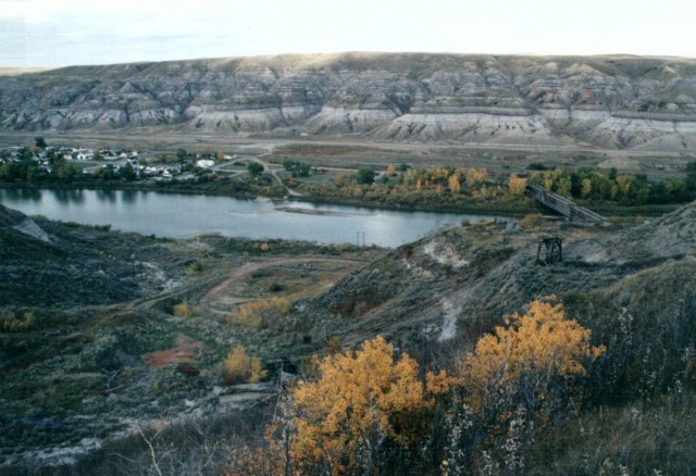
The Red Deer River valley is like a magnet to me. It’s an oddly beautiful place and I love the interesting landscapes, but it’s also home to a good number of historical sites that can be explored. On this trip I take a look at the East Coulee area which is home to a number of old coal mines and an interesting combination road/rail bridge.
The images here were taken in 1992 and were scanned from 35mm prints. Compare the views here with ones we took in 2012 (link below).
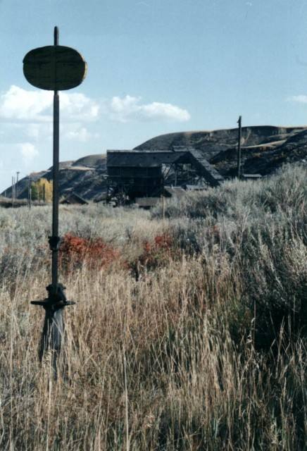
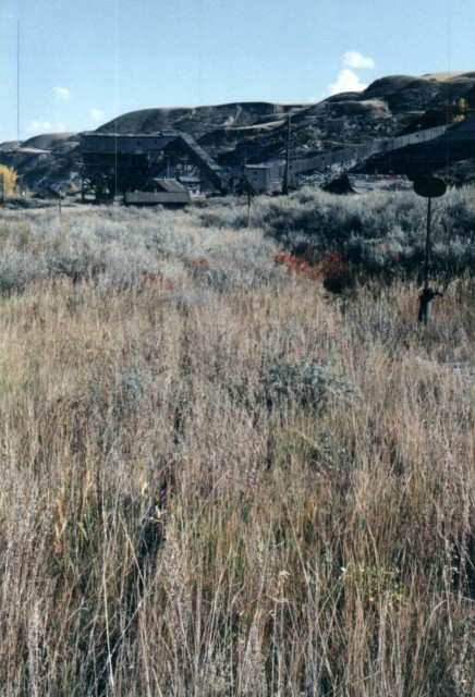
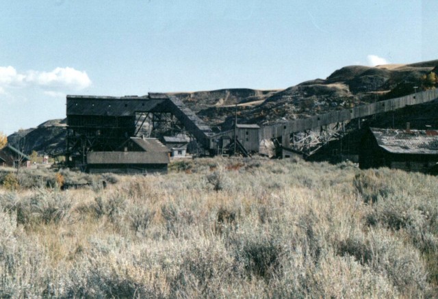
The first thing we see on entering the area is the historic Atlas Mine, its imposing tipple looming high over us. The very last operating coal mine in the Red Deer River Valley, they loaded rail cars here into the late 1970s (others have told me the early 1980s). After shutting down the complex stood abandoned for a number of years prior to it becoming a protected historical site a bit later in the 1980s. Thank goodness as I am sure it wouldn’t have been long before the place succumbed to the elements or was vandalized.
↓ ↓ ↓ ↓ Scroll down for photos or to comment ↓ ↓ ↓ ↓
In the ensuing years the site has been cleaned up and fixed and made accessible to visitors. However, during the time I was there not much visual work had been done, so it looked very much as left when the mine shut down. There was lots of equipment scattered about (but behind high fences) and everything had that look – you know, like they just stopped work and up and left one day. The buildings seen here date from the 1930s and are the last of their kind in Canada.
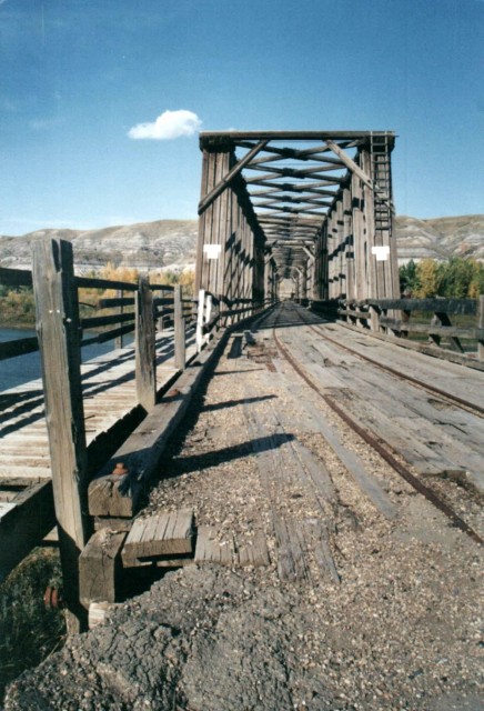
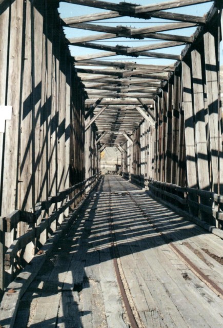
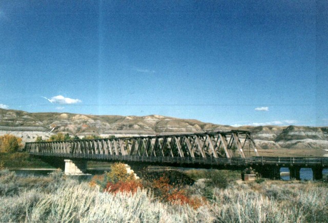
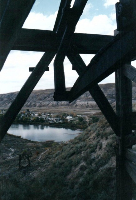
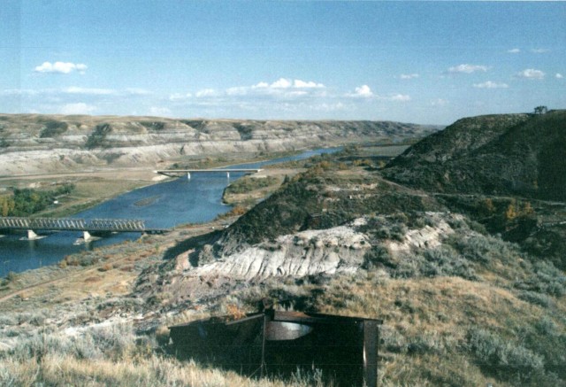
To the west of the Atlas is the much photographed East Coulee road/rail bridge. The structure was built to allow trains to access the mines (and grain elevator) that were located on the south side of the Red Deer River. It was also used by autos and I assume workers heading into the mines. At the time of my visit the last train would have traversed the bridge some dozen years earlier. It’s not clear if it was closed to car traffic immediately after that.
On our visit in 2012 the bridge deck was rather overgrown and the planks rotted looking, but in 1992 it was clear and everything looked solid. The bridge itself was built around the time the mines here opened, so around 1936, although others have told me 1948. I think those people might be wrong – I believed it was damage by ice that year and rebuilt.
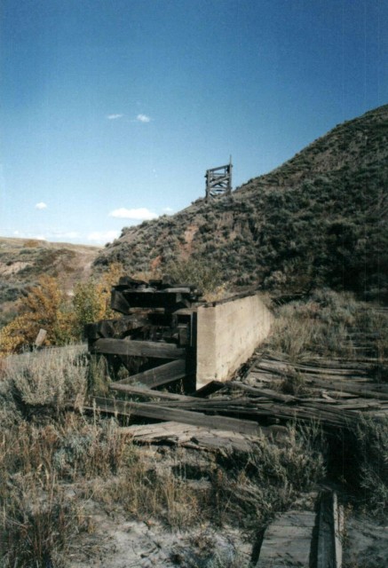
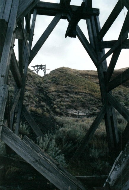
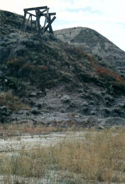
The abandoned Murray Mine is located nearby. Opened in 1936, it closed in 1959, making it one of the last to operate in the valley – perhaps two or three others struggled through the 1960s and one remained in the 1970s (the Atlas next door). Not much remains here but if you look hard you can find the opening (sealed), some scattered machinery, along with the tramway towers that took spoil and waste away from the mine. They headed to a side valley where there it appears they dumped the slack and rock and other junk. There are no remains of the tipple and processing plant, although this author has seen pictures showing where each was located.
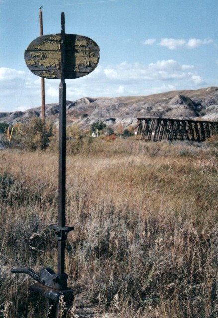
There was a small train yard between the bridge and mine, although it was so overgrown making it hard to spot. Only the occasional switch stand poking out from the thick underbrush confirmed what was here.
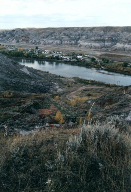
The grain elevator mentioned, by the way, was located just east of and north of the Atlas Mine. The two were very close together and it’s an odd mix seeing coal and grain is such close proximity to each other. This elevator shut down and was demolished about the time the Atlas closed. Also nearby was one additional mine, the Western Monarch, which was located just east by the highway that leads south of East Coulee. I did not know it existed at the time of this visit and I only found out about it recently (2012). I am always learning.
An odd thing about coal mines in East Coulee (and the whole area) is that their output was almost exclusively for heating coal and very little if any was used for industrial purposes. Because of this the mines were never that huge and had sometimes they very long service lives. Many only operated seasonally.
Because of the market, much of this coal was shipped in boxcars instead of hoppers which may seem odd (although I have seen one picture showing a hopper at the Atlas). The nature of the product dictated that it needed to be shipped covered and if exposed to the elements it would break down quickly. It’s possible the Atlas was the very last that used boxcars for coal loading. Interestingly, grain was often shipped in boxcars as well, well into the 1990s in fact.
The Drumheller area/Red Deer River valley was once home to countless coal mines. Hundreds I am told. some small one man operations, some large like the Atlas. Coal from the valley was shipped all over Western Canada and perhaps even beyond.
Fantastic bridge pictures Chris and Connie. I first walked on the bridge in l988. My grandfather, Jim Murray’s family house on about an acre was by the bridge on the East Coulee side. That bridge is one of a kind!
I’ve driven across the old bridge quite a few times, between at least ’77 to when the new bridge was already present. Now, there is no way I’d even want to walk out on it! Somewhere, I have photos of the old bridge; the wooden beams used to build it were huge. Unfortunately two moves in the last two years have led to those photos being packed away in some mysterious place. Hope to find them….
I lived in the monarch mining camp just above the entrance to the mine. My father was the bookkeeper at the atlas and Monarch mine for about 6 years from 67 to 72. The Monarch was bulldozed over and nothing remains. about 1 km south on the road that the new bridge takes you. There is a fork in the road at the bottom of the first hill the monarch was on the left on the hill. A wonderful place to grow as a child so long ago miss it very much. Your article has made me mark my calendar to return this summer for a visit.
Fantastic! The Monarch is often overshadowed by the Atlas. On Google Earth, one can see what looks to be faint lines, a grid of them, perhaps marking old roads just east of where the Monarch Tipple was. I suspect this is where worker’s housing was. You won’t regret revisiting the place, I’m sure of that.
My mother managed a restaurant in the hotel in the Monarch area in 1949 or 1950 and again in 1956. This hotel was moved to Hussar in 1959. I have pictures of it being moved. There is nothing there now. At that time there were dozens of houses.
Interesting, I saw those images you mentioned and indeed it’s clear there is no roadway on the bridge at that date. This adds to the mystery and so far no one can answer when the bridge was opened to auto traffic and when it was closed to the same. We know it hosted trains from the time of its opening until the late 1970s or perhaps early 1980s. I first saw it in 1992 (the pics you see here) and it looked like the bridge had been unused for some time at that point.
We used to do something called the "pointless challenge" 🤪 and miss those days. It was so much silly fun and often frustrating as heck. In these we'd invite people to send in random photos of obscure locations, but not give any information, and then we'd track where it was and shoot something similar.
Most of these came from old family collections, as was the case here. Anyone up to resurrecting the series?
In hindsight, why didn't we pose someone in our shot?
Pointless: “Devoid of meaning (or) senseless” Merriam-Webster.
If you like what we do and want to support this ongoing project (12 years now), go here: https://www.BIGDoer.com/help-the-society/ Thanks to Connie for making this post possible.
Exploring history with Off the Beaten Path with Chris & Connie. Photo: ca1970 and 2014. Posted by Connie.
Captured on a cold, cold day many years ago. We've been passing this old house for decades and it's little changed in that time. At some point we expect to drive by and it'll be gone.
Exploring history with Off the Beaten Path with Chris & Connie. Photo: 2017. Posted by Connie.
When retired old railway cars usually get cut up for scrap. Sometimes, however, they find their way into the hands of the general public or whomever. Flat cars make good bridges, and boxcars can be transformed into storage buildings and the like. Case in point here. We see them used like this often enough and in this case, it's part of a corral.
Incidentally, this boxcar dates from 1950 and this was found by tracing the old road number, which is still visible.
Exploring history with Off the Beaten Path with Chris & Connie. Photo: 2017. Posted by Connie.
This central Alberta racetrack was never a commercial operation but instead just a fun place for car enthusiasts in the area to get together. Early '70s or thereabouts and it only lasted a few years. Even thought it's been abandoned for that long, there is no doubt what was here.
You know we like the the obscure stuff and this one fits the bill perfectly. Found by accident while backroad cruising and the history comes thanks to local car guy Mike.
Exploring history with Off the Beaten Path with Chris & Connie. Photo: 2022. Posted by Connie.
On top of little Myrtle Mountain in the Kimberley (BC) Nature Park.
There's some good wilderness fun to be had here and nice views as you can see, but the real reason we came is mining history. The whole area near the ski hill was extensively worked over a century ago and we were looking for evidence of this. We didn't find much in the area searched, but it's a big chunk of property and we hope to return to cover more ground again soon. Of all the subjects we cover, mining related is a favourite.
Still, it was a good hike and that can't be bad. Look to the comments for more info 👇.
Exploring nature and history with Off the Beaten Path with Chris & Connie. Photo: 2022. Posted by Connie.
It's a strange curiosity in south Kananaskis, there on a hillside and we have no idea who created it. We asked around and no one's completely sure about its history. In the past it showed the Canada 100 logo from 1967 but in 2017 someone changed it to reflect the country's 150th.
That's our friend Emily from DanOCan.com having a look.
Exploring history with Off the Beaten Path with Chris & Connie. Photo: 2017. Posted by Connie.
Javascript is required for this site to function. Please enable it in your browser settings and refresh this page.
Please log-in to continue... This allows unrestricted access to every post @BIGDoer.com, popups are eliminated, commenting is on and the "contact us" page is enabled.
Your social site may send you a routine notice of login.
Or signup, here: Subscriber Register ___ BIGDoer.com: Serving up POP HISTORY & other McFun!…(Mmmm, yummy bite-sized pieces.) One million plus words & tens of thousands of photos!


")


My father grew up in East Coulee Alberta. He was born in 1939. I can ask him about the bridge. My Mother is from Drumheller
Sure, if he has anything to add, we’d love to hear from him. Thanks for commenting!
Fantastic bridge pictures Chris and Connie. I first walked on the bridge in l988. My grandfather, Jim Murray’s family house on about an acre was by the bridge on the East Coulee side. That bridge is one of a kind!
It sure is unique.
I’ve driven across the old bridge quite a few times, between at least ’77 to when the new bridge was already present. Now, there is no way I’d even want to walk out on it! Somewhere, I have photos of the old bridge; the wooden beams used to build it were huge. Unfortunately two moves in the last two years have led to those photos being packed away in some mysterious place. Hope to find them….
If you ever find those photos, Connie and myself and the readers of this blog would no doubt love to see them. Thanks for sharing!
The Monarch Mine was just east of the Atlas but there is nothing really in the way of remains to identify where it was.
I lived in the monarch mining camp just above the entrance to the mine. My father was the bookkeeper at the atlas and Monarch mine for about 6 years from 67 to 72. The Monarch was bulldozed over and nothing remains. about 1 km south on the road that the new bridge takes you. There is a fork in the road at the bottom of the first hill the monarch was on the left on the hill. A wonderful place to grow as a child so long ago miss it very much. Your article has made me mark my calendar to return this summer for a visit.
Fantastic! The Monarch is often overshadowed by the Atlas. On Google Earth, one can see what looks to be faint lines, a grid of them, perhaps marking old roads just east of where the Monarch Tipple was. I suspect this is where worker’s housing was. You won’t regret revisiting the place, I’m sure of that.
My mother managed a restaurant in the hotel in the Monarch area in 1949 or 1950 and again in 1956. This hotel was moved to Hussar in 1959. I have pictures of it being moved. There is nothing there now. At that time there were dozens of houses.
It’s amazing what was, but now gone and forgotten. Only a few folks know about Monarch, which is a bit sad. But time travels on.
There are some pictures to be found at the Glenbow picture archive and these show the bridge in 1948 with no roadway decking.
Interesting, I saw those images you mentioned and indeed it’s clear there is no roadway on the bridge at that date. This adds to the mystery and so far no one can answer when the bridge was opened to auto traffic and when it was closed to the same. We know it hosted trains from the time of its opening until the late 1970s or perhaps early 1980s. I first saw it in 1992 (the pics you see here) and it looked like the bridge had been unused for some time at that point.