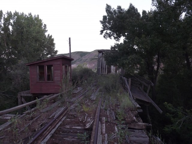
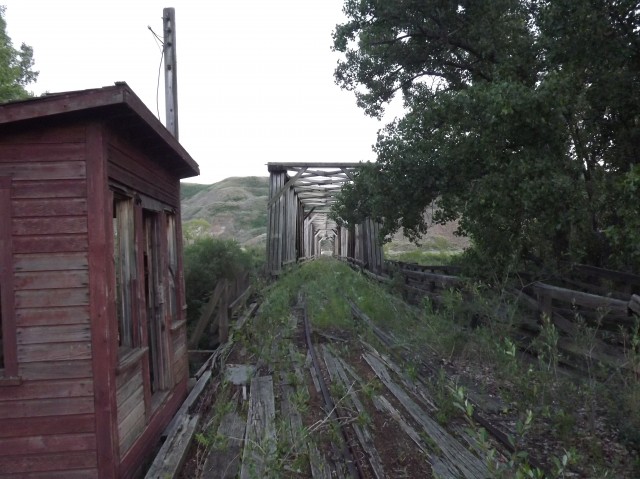
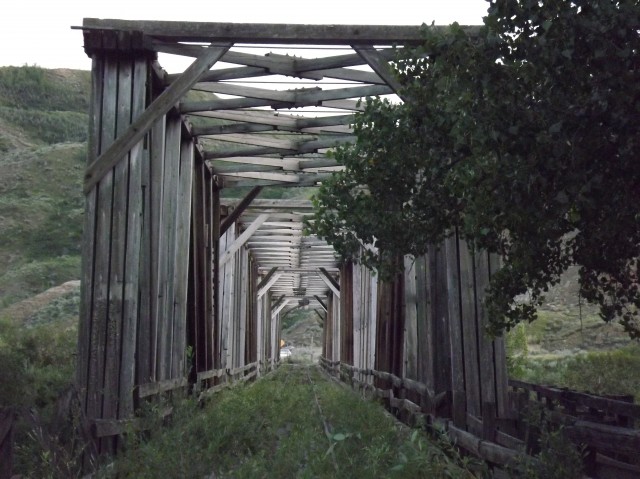
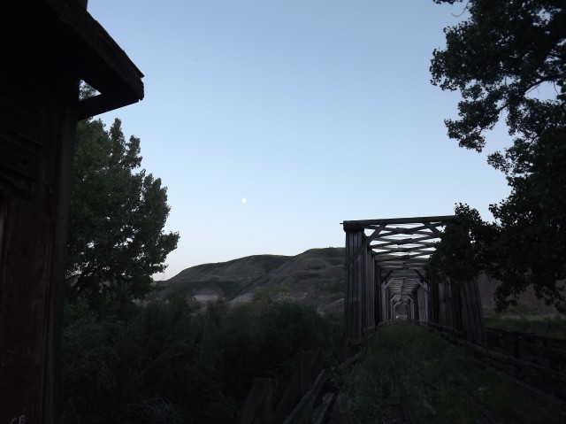
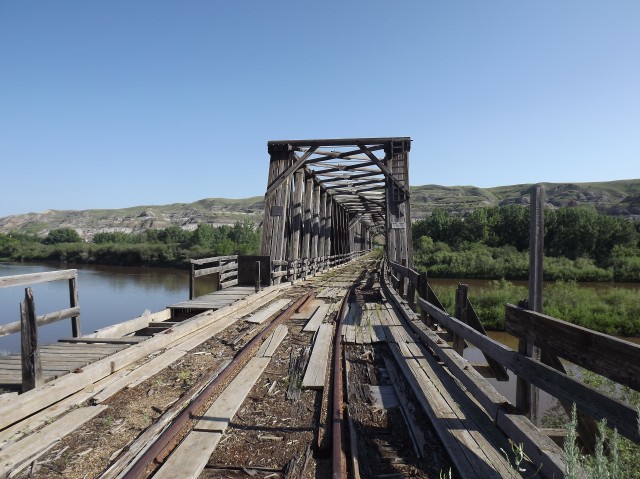
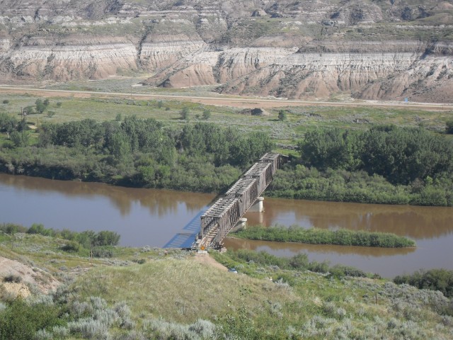
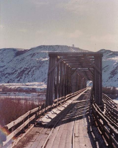
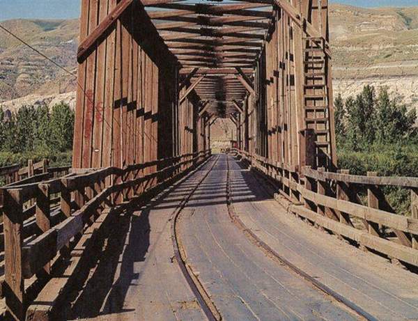
Built to service the coal mines on the south side of the Red Deer river valley, the East Coulee bridge is an amazing piece of local history. Unusual and rare in design it was used both by trains and vehicular traffic on a common shared roadway. Today, the structure is abandoned but that could change if plans to save it come to fruition.
The rail line using the bridge was a spur track coming off a joint CPR/CNR branch line on the north side of the river at the town of East Coulee, allowing trains to access and service both the Murray Mine (not much left) and the Atlas Mine (now an historical site) on the opposite bank. During boom years train after train left those busy operations via this unique structure. From there the coal, mostly used for domestic heating, travelled to all points in Western Canada and perhaps beyond. With the change over to natural gas the demand for the product slowed. The Murray mine closed in 1959 and the Atlas mine, the last in the Drumheller/Red Deer River valley, followed by 1980s. Near the end the Atlas mine only worked sporadically, usually in winter.
↓ ↓ ↓ ↓ Scroll down for photos and to comment ↓ ↓ ↓ ↓
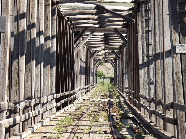
This whole time the bridge did its job, allowing trains to reach the mine, and auto traffic to head south (and miners I assume heading for work). Since the addition of a new road bridge further east, the old bridge was closed to all traffic and has since fallen into disrepair. Even so and in spite of how bad it looks, the basic structure seems pretty solid – not that I am a bridge engineer. I am certain if caught in time it could be saved and fixed up. It’s very historically significant and could be easily incorporated into the Atlas mine complex nearby.
I have not been able to find exactly when the bridge was built but I was told anywhere from the 1930s to 1948. I could not find a date stamp in the concrete – bridge builders often include one – but none was found by this author. Regardless of the exact year within that time span, the use of wood construction seems odd. At this later date one would assume steel would be used. The design certainly makes it look much older than it is.
There is a guard house on the north (town) side of the bridge and I assume this person’s job was to block vehicular traffic when a train was due.
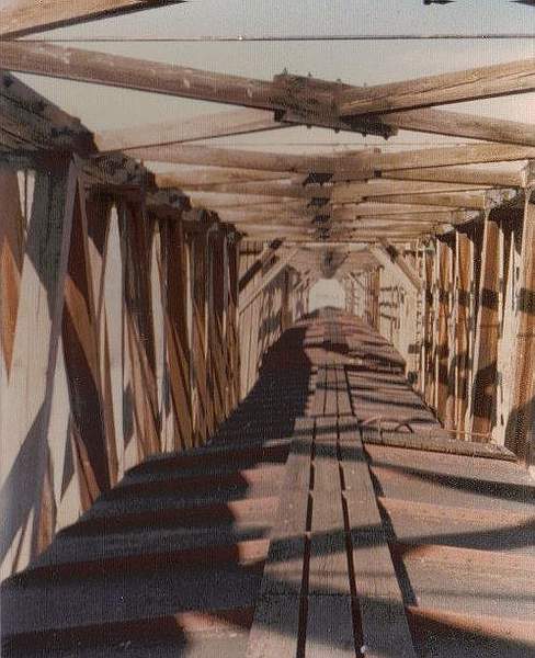
Warning, much of the deck planking is rotting away and is dangerous. Do not venture out on the bridge.
The images at the bottom of this report are compliments of and copyright Larry Buchan and show scenes around the bridge near the time the last mine was operating. Larry was employed with the CPR and in the 1970s spent time in the valley working wayfreights (local milk-stop type trains) up and down the line.
He send me this fascinating tidbit about the bridge…
“I remember towards the end of operation using this bridge, came in the late 1970s, we had joint rights with the CNR as far as switching the Atlas Mine was concerned, we would do it for six months of the year, and CNR would do it the other six months, they would come down with big power and were not supposed to go over the bridge with more than one unit, evidently one week they were in a hurry to get over to the mine and out of East Coulee before their train orders expired, so they went over to the mine with three locomotives, this made the bridge unsafe for locomotives to go over, I made one last trip down there in the spring of 1979 when I was taking my locomotive engineers training, so at that time the mine would run the loads down onto the bridge controlling them with handbrakes, we would then picked them off the bridge using other boxcars as reachers if we had to. The mine soon stopped operation not long after this.”
To visit Larry’s very interesting blog, where we shares stories about his time working the rails click here.
BIG Update: December 2012. I have stumbled across more information about the bridge and the industries it served, some of which clears things up, others that deepen the mystery and some that add a whole new dimension the story.
1) An Alberta Pacific grain elevator used to sit very close to the Atlas Mine, almost within throwing distance. It had its own spur and lasted until about 1980 before being torn down, although it’s believed that rail service to it had ended sometime earlier. This author has seen a picture from the mid 1970s and the structure looks disused and the spur line to it overgrown and rusty. Our friend Larry Buchan who is mentioned further above in this article does not recall ever spotting cars at the elevator. He worked for the CPR in the area in the 1970s and kept meticulous records of his experiences.
2) In the same picture showing the elevator one can spot two coal hoppers siting on the Atlas Mine tracks. This is a odd, as my understanding is that coal from these mines was always shipped in boxcars and any photos I have seen show endless strings of them parked at the mine. Hoppers are never seen except in this one single picture. The output of the mine was mostly domestic heating and cooking coal and it travelled in boxcars since few if any of the coal distributors had facilities to accept bottom dumping hoppers. I guess it’s possible some output was for industrial purposes, which could explain these cars. Although I have heard that Drumheller region coal does not travel well when exposed to the the elements – I guess it breaks down quickly. So, it gets more confusing and this mystery remains.
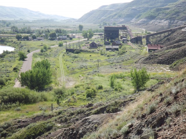
3) Almost next door to the Atlas Mine was the Monarch Mine, or Western Monarch Mine (I have seen both spellings) and this author has only just found out out it; after my last field visit to the area. This mine lasted until the 1960s making it one of the last to operate in the valley. It too was served by the bridge and had it’s own small yard to feed the tipple. I don’t think there are any bits or pieces of the mine left although I expect some field research is in order to confirm this.
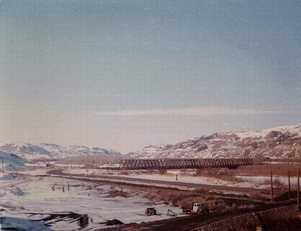
4) In the article above I state the bridge could have been built sometime between the 1930s and 1948. The former now seems likely since I have found a picture of the bridge from 1948 showing it being repaired. One span was skewed and shifted and while it’s assumed that river ice may have done this (given it appears to be spring in the picture), the text that accompanies the picture mentions some damage due to dynamite, without explaining what explosives had to do with it. Dynamite? This invites further research.
5) Seen in that same picture mentioned in the paragraph above is one important fact. In 1948, the bridge was train only and no road decking is seen. So for a period at least, it was just a plain old railway bridge and when the road was added is not know. Again, this invites further research.
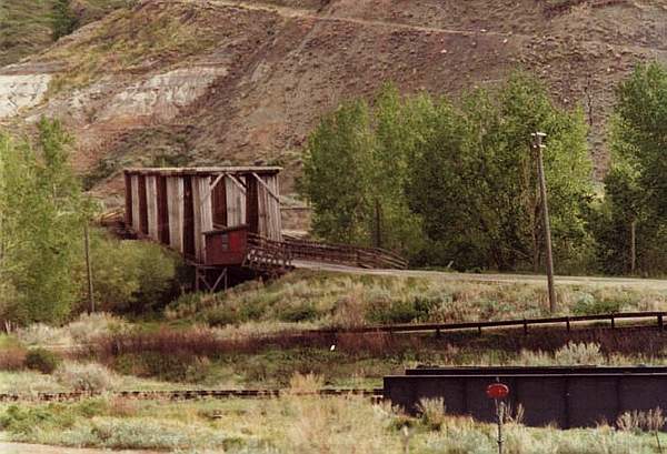
6) Into the 1970s, there was sizeable yard, depot and turntable on the north side of the bridge. In one of the pictures supplied by Larry Buchan, one can see the former. On Google Earth a half moon shaped feature can be seen just above the bridge hinting at the location of the turntable. It seems to line up with the picture Larry supplied. Otherwise nothing really remains of the yard.
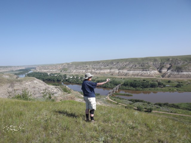
The town of East Coulee can be seen in behind Connie.
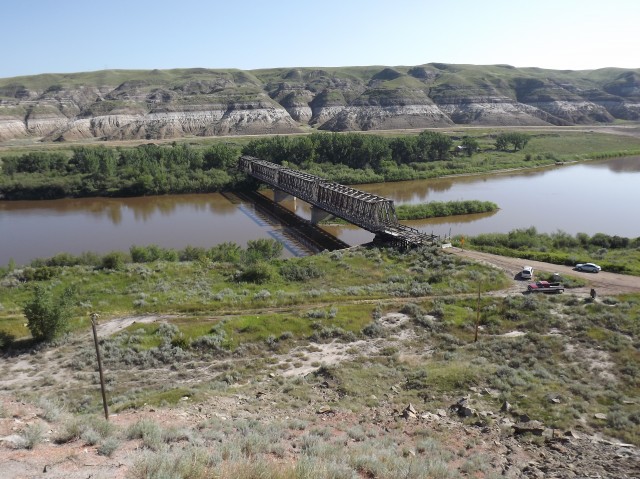
The bridge crosses the Red Deer River.
The Atlas Mine historic site. The grain elevator used to sit just left of it, the Monarch Mine just above it and the Murray Mine behind the photographer.
The bridge seen from the Atlas mine, taken in 1974. Image is copyright Larry Buchan.
From 1974, taken while riding a boxcar across the bridge. Compliments of Larry Buchan.
This image taken in 1976 and is copyright Larry Buchan.
The bridge seen from the north (town) side. Note the old turntable. This image was supplied by Larry Buchan and was taken in 1976.
A string of boxcars crossing the bridge. Image supplied by Larry Buchan.
The 1948 dynamiting was to dislodge heavy spring ice that had built up around the piers and the pressure was so great that it was starting to shift the bridge downstream. The plan was to loosen the ice but the resultant explosion shifted the pier instead and the damage you saw was from this botched attempt.
I lived in East Coulee from 1947 to 1959 and I have a lot of memories of the Valley. They must have dynamited the bridge more than once because the one I remember was probably 1952 or 53. I also remember houses floating down the river with the ice. The bridge was out of commission for months until it was rebuilt. There was also another mine on the town side of the river called the Empire. I had family working in all of them My Dad worked in both the old Atlas and he was part of the crew who opened the new Atlas Mine.
According to the Atlas of Alberta Railways http://railways.library.ualberta.ca/Maps-7-1-7/ The line from Kneehill to East Coulee was completed on June 27, 1929 and the CNR connection at Rosedale was tied in July 20, 1927. The line from East Coulee to Rosemary was opened June 27, 1929.
I love finding “Rare Hidden Gems” like this and I have been trying to connect Hussar, from Rosemary to East Coulee, by way of the Old Railway lines. Have you had a chance to explore any of those lines?
We used to do something called the "pointless challenge" 🤪 and miss those days. It was so much silly fun and often frustrating as heck. In these we'd invite people to send in random photos of obscure locations, but not give any information, and then we'd track where it was and shoot something similar.
Most of these came from old family collections, as was the case here. Anyone up to resurrecting the series?
In hindsight, why didn't we pose someone in our shot?
Pointless: “Devoid of meaning (or) senseless” Merriam-Webster.
If you like what we do and want to support this ongoing project (12 years now), go here: https://www.BIGDoer.com/help-the-society/ Thanks to Connie for making this post possible.
Exploring history with Off the Beaten Path with Chris & Connie. Photo: ca1970 and 2014. Posted by Connie.
Captured on a cold, cold day many years ago. We've been passing this old house for decades and it's little changed in that time. At some point we expect to drive by and it'll be gone.
Exploring history with Off the Beaten Path with Chris & Connie. Photo: 2017. Posted by Connie.
When retired old railway cars usually get cut up for scrap. Sometimes, however, they find their way into the hands of the general public or whomever. Flat cars make good bridges, and boxcars can be transformed into storage buildings and the like. Case in point here. We see them used like this often enough and in this case, it's part of a corral.
Incidentally, this boxcar dates from 1950 and this was found by tracing the old road number, which is still visible.
Exploring history with Off the Beaten Path with Chris & Connie. Photo: 2017. Posted by Connie.
This central Alberta racetrack was never a commercial operation but instead just a fun place for car enthusiasts in the area to get together. Early '70s or thereabouts and it only lasted a few years. Even thought it's been abandoned for that long, there is no doubt what was here.
You know we like the the obscure stuff and this one fits the bill perfectly. Found by accident while backroad cruising and the history comes thanks to local car guy Mike.
Exploring history with Off the Beaten Path with Chris & Connie. Photo: 2022. Posted by Connie.
On top of little Myrtle Mountain in the Kimberley (BC) Nature Park.
There's some good wilderness fun to be had here and nice views as you can see, but the real reason we came is mining history. The whole area near the ski hill was extensively worked over a century ago and we were looking for evidence of this. We didn't find much in the area searched, but it's a big chunk of property and we hope to return to cover more ground again soon. Of all the subjects we cover, mining related is a favourite.
Still, it was a good hike and that can't be bad. Look to the comments for more info 👇.
Exploring nature and history with Off the Beaten Path with Chris & Connie. Photo: 2022. Posted by Connie.
It's a strange curiosity in south Kananaskis, there on a hillside and we have no idea who created it. We asked around and no one's completely sure about its history. In the past it showed the Canada 100 logo from 1967 but in 2017 someone changed it to reflect the country's 150th.
That's our friend Emily from DanOCan.com having a look.
Exploring history with Off the Beaten Path with Chris & Connie. Photo: 2017. Posted by Connie.
Javascript is required for this site to function. Please enable it in your browser settings and refresh this page.
Please log-in to continue... This allows unrestricted access to every post @BIGDoer.com, popups are eliminated, commenting is on and the "contact us" page is enabled.
Your social site may send you a routine notice of login.
Or signup, here: Subscriber Register ___ BIGDoer.com: Serving up POP HISTORY & other McFun!…(Mmmm, yummy bite-sized pieces.) One million plus words & tens of thousands of photos!


Great post, thanks for sharing this blog. That bridge is so fascinating and I must visit it! Thanks again, I’ll be back.
I got tons like this. All Rare Hidden Gems.
It’s a wonderful bridge!
The 1948 dynamiting was to dislodge heavy spring ice that had built up around the piers and the pressure was so great that it was starting to shift the bridge downstream. The plan was to loosen the ice but the resultant explosion shifted the pier instead and the damage you saw was from this botched attempt.
Wow, that clears up that mystery! Do you know when the bridge had the road deck added?
I lived in East Coulee from 1947 to 1959 and I have a lot of memories of the Valley. They must have dynamited the bridge more than once because the one I remember was probably 1952 or 53. I also remember houses floating down the river with the ice. The bridge was out of commission for months until it was rebuilt. There was also another mine on the town side of the river called the Empire. I had family working in all of them My Dad worked in both the old Atlas and he was part of the crew who opened the new Atlas Mine.
Ahhh. Thanks so much for adding to the story. Wow! Yes, the Empire. So many mines in the area.
According to the Atlas of Alberta Railways http://railways.library.ualberta.ca/Maps-7-1-7/
The line from Kneehill to East Coulee was completed on June 27, 1929 and the CNR connection at Rosedale was tied in July 20, 1927. The line from East Coulee to Rosemary was opened June 27, 1929.
Awesome, thank you so much for your comment. I’ve relied on the webpage you mentioned many times – it’s a great resource!
I love finding “Rare Hidden Gems” like this and I have been trying to connect Hussar, from Rosemary to East Coulee, by way of the Old Railway lines. Have you had a chance to explore any of those lines?
We’ve followed many old rail lines in the area. Search “Bullpound” to see an abandoned train bridge east of East Coulee.