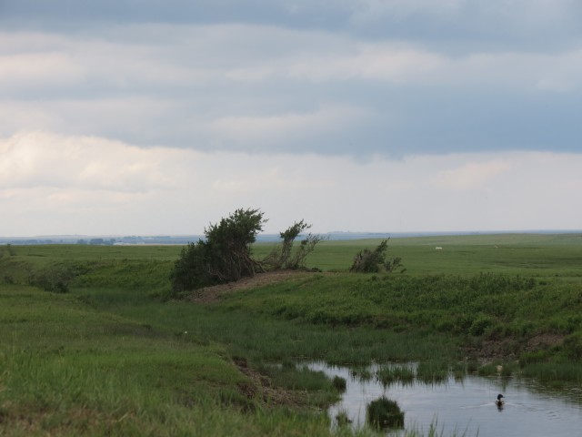
The berm we see here, cutting across a farmer’s field, is in fact the grade of a proposed rail line, unfinished and abandoned before completion. Passing by it seems of little significance, but over one hundred years ago when it was built, there were great plans afoot to open up the agriculture potential of the area south and west of Fort MacLeod Alberta.
Built under the charter of the Alberta Midland Railway, a Canadian Northern Railway (CNoR) subsidiary, a line was planned south from Calgary, into Fort MacLeod, then south then west to a point on the map called Fishburn – today called Twin Butte – a proposed town, but never more then a crossroads. They even planned to go further west but it’s unclear where, although Pincher Creek was mentioned as one possibility. It’s safe to say they had their sights set on BC, based upon some maps this author has seen which show some possible routes the line could potentially use.
Don’t forget to LIKE or SHARE this post.
The grade we see here dates from 1912 and two sections of this line were completed before they abandoned the project. One travelled south of Calgary to a point near High River (some traces can be found) while the other is the the subject of this report. Work, outside of presumably surveying, was never started on the middle section. Even so, they still managed to complete a significant amount of work before the plug was pulled.
This entire line would have been well over 200km long and was significant as it would have allowed the CNoR to penetrate deep into CPR territory. For quite some time that railway enjoyed an uncontested monopoly in the area and this new line would have broken that. It’s was to be a large and ambitious undertaking.
This author, using Google Earth, has been able to identify and follow the old grade from Fort MacLeod, to a point perhaps approximately half way to its intended destination. It initially heads south, then turns west at the Waterton River, roughly paralleling it but above it on the prairie, to a farmer’s field where it unceremoniously ends. About half the route can be easily spotted, even in person, and the grade is obvious. The rest of the way, the route has been plowed under with little or nothing to be seen. Even so, it’s amazing to think that even a hundred years later, the work done can still be discovered.
We are unsure if the rail bed as we see it was ready for track or if its only a rough grade and further work was needed. From what we can see, no bridges were yet constructed along the line, nor any other infrastructure for that matter.
It’s not clear why the line was unfinished. Perhaps funding ran out, or in rethinking the line, it’s possible they realized it may not have been the money maker hoped for. It was a real leap of faith after all and at the time there were not even towns along much of the proposed line, although I am sure some were planned.
It’s rare to see an unfinished line such as this, but even so this author has been able to identify many in the province, some of which I am sure we’ll visit over time.
This line was built during the great railway construction boom that took place in the early decades of the twentieth century (the busiest period was 1910-1930). At that time, rail lines across the prairies were being built at a feverish pace and anywhere there was a town, no matter how small, a rail line would be built to it. In fact sometimes a line was built where there was no towns, in hopes that some would spring up after a line was built. Wow! Later all the railways would regret building these lines, most were money losers, and now most have been abandoned.
The Alberta Midland was a paper railway controlled by the CNoR. Using a “local” subsidiary like this offered certain advantages through various incentives and tax breaks, then if the larger company itself built the line. Of course, once it was finished, or not long after, it would almost immediately be folded into the parent company.
It would be interesting to see what would have happened had the line been finished. One thing is for certain, the whole area would have been a totally different place than what we see today.
The Canadian Northern Railway amalgamated with a number of other lines in the early 1920s becoming the Canadian National Railways we know today.
We plan to return to study more of this line. Plus we hope to document the other section that was built near Calgary. It can be traced in places although housing developments have obliterated most of it.
I stumbled across this posting when I was following up on a mysterious Canadian Northern Railway line that was shown on an old map of the junction of Fish Creek and the Bow River in what is now Calgary. I love to follow up on anything mysterious and relatively unknown and this railway fits the bill. I’m going to keep researching this in hopes of answering some of the “whys”.
Part of that roadbed you mentioned can be followed to a point near High River. It’s hard to see in places, but it’s there. I’ve researched it, and it was to connect to the line we documented by Fort MacLeod. The CNoR hoped to break the CPR’s monopoly in the area. Of course, the project died on the vine.
Thanks for your reply. The research I’ve done so far seems to indicate that rails may not have been laid on any parts of this proposed line. Only some surveying and some miles of graded road bed?
I should have known the BigDoer blog would have had answered this question for me from the outset! The land titles online map shows this track as Canadian National, but I suspect that was a transcription error (CNR/CNoR) – I’ve been researching some of the history in the community I live, which parallels the bow bottom area described by Paul – and followed the track through some airphotos. Too bad there won’t be any rail remnants along this unique route – but it is amazing how it impacts the landscape for many decades. Thanks for this great history Paul and Chris. -David from South Calgary
Check out this post…Unfinished Railway Line Calgary Yes, that could be a typo as the line was build long before the CNoR was amalgamated into the CNR. Or maybe it was held on to a for a long time in hopes the project could be restarted at some point. Either way, it’s fascinating. How amazing that something built so long ago, then forgotten, can be found if you just take the time to look.
The funny thing was, the Galts had at one time actually proposed to extend the narrow gauge (St. Mary’s River Railroad) – from Woolford south into Montana…
The line was to travel all the way from Calgary, through Fort MacLeod, then following the Waterton River, to points west. A section of the grade near each end was started. This construction dates from 1912.
We used to do something called the "pointless challenge" 🤪 and miss those days. It was so much silly fun and often frustrating as heck. In these we'd invite people to send in random photos of obscure locations, but not give any information, and then we'd track where it was and shoot something similar.
Most of these came from old family collections, as was the case here. Anyone up to resurrecting the series?
In hindsight, why didn't we pose someone in our shot?
Pointless: “Devoid of meaning (or) senseless” Merriam-Webster.
If you like what we do and want to support this ongoing project (12 years now), go here: https://www.BIGDoer.com/help-the-society/ Thanks to Connie for making this post possible.
Exploring history with Off the Beaten Path with Chris & Connie. Photo: ca1970 and 2014. Posted by Connie.
Captured on a cold, cold day many years ago. We've been passing this old house for decades and it's little changed in that time. At some point we expect to drive by and it'll be gone.
Exploring history with Off the Beaten Path with Chris & Connie. Photo: 2017. Posted by Connie.
When retired old railway cars usually get cut up for scrap. Sometimes, however, they find their way into the hands of the general public or whomever. Flat cars make good bridges, and boxcars can be transformed into storage buildings and the like. Case in point here. We see them used like this often enough and in this case, it's part of a corral.
Incidentally, this boxcar dates from 1950 and this was found by tracing the old road number, which is still visible.
Exploring history with Off the Beaten Path with Chris & Connie. Photo: 2017. Posted by Connie.
This central Alberta racetrack was never a commercial operation but instead just a fun place for car enthusiasts in the area to get together. Early '70s or thereabouts and it only lasted a few years. Even thought it's been abandoned for that long, there is no doubt what was here.
You know we like the the obscure stuff and this one fits the bill perfectly. Found by accident while backroad cruising and the history comes thanks to local car guy Mike.
Exploring history with Off the Beaten Path with Chris & Connie. Photo: 2022. Posted by Connie.
On top of little Myrtle Mountain in the Kimberley (BC) Nature Park.
There's some good wilderness fun to be had here and nice views as you can see, but the real reason we came is mining history. The whole area near the ski hill was extensively worked over a century ago and we were looking for evidence of this. We didn't find much in the area searched, but it's a big chunk of property and we hope to return to cover more ground again soon. Of all the subjects we cover, mining related is a favourite.
Still, it was a good hike and that can't be bad. Look to the comments for more info 👇.
Exploring nature and history with Off the Beaten Path with Chris & Connie. Photo: 2022. Posted by Connie.
It's a strange curiosity in south Kananaskis, there on a hillside and we have no idea who created it. We asked around and no one's completely sure about its history. In the past it showed the Canada 100 logo from 1967 but in 2017 someone changed it to reflect the country's 150th.
That's our friend Emily from DanOCan.com having a look.
Exploring history with Off the Beaten Path with Chris & Connie. Photo: 2017. Posted by Connie.
Javascript is required for this site to function. Please enable it in your browser settings and refresh this page.
Please log-in to continue... This allows unrestricted access to every post @BIGDoer.com, popups are eliminated, commenting is on and the "contact us" page is enabled.
Your social site may send you a routine notice of login.
Or signup, here: Subscriber Register ___ BIGDoer.com: Serving up POP HISTORY & other McFun!…(Mmmm, yummy bite-sized pieces.) One million plus words & tens of thousands of photos!


Hi….
I stumbled across this posting when I was following up on a mysterious Canadian Northern Railway line that was shown on an old map of the junction of Fish Creek and the Bow River in what is now Calgary. I love to follow up on anything mysterious and relatively unknown and this railway fits the bill. I’m going to keep researching this in hopes of answering some of the “whys”.
Paul Sutherland
Calgary
Hi Paul,
Part of that roadbed you mentioned can be followed to a point near High River. It’s hard to see in places, but it’s there. I’ve researched it, and it was to connect to the line we documented by Fort MacLeod. The CNoR hoped to break the CPR’s monopoly in the area. Of course, the project died on the vine.
Have a great week!
Thanks for your reply. The research I’ve done so far seems to indicate that rails may not have been laid on any parts of this proposed line. Only some surveying and some miles of graded road bed?
What is your take on this?
Thanks,
Paul
That’s right, only basic grading took place, but no track was put down.
I should have known the BigDoer blog would have had answered this question for me from the outset! The land titles online map shows this track as Canadian National, but I suspect that was a transcription error (CNR/CNoR) – I’ve been researching some of the history in the community I live, which parallels the bow bottom area described by Paul – and followed the track through some airphotos. Too bad there won’t be any rail remnants along this unique route – but it is amazing how it impacts the landscape for many decades. Thanks for this great history Paul and Chris.
-David from South Calgary
Check out this post…Unfinished Railway Line Calgary
Yes, that could be a typo as the line was build long before the CNoR was amalgamated into the CNR. Or maybe it was held on to a for a long time in hopes the project could be restarted at some point. Either way, it’s fascinating. How amazing that something built so long ago, then forgotten, can be found if you just take the time to look.
The funny thing was, the Galts had at one time actually proposed to extend the narrow gauge (St. Mary’s River Railroad) – from Woolford south into Montana…
Wow, that’s interesting!
Hey this is cool, is this line that was supposed to go to Stirling? I didn’t know they actually started it.
The line was to travel all the way from Calgary, through Fort MacLeod, then following the Waterton River, to points west. A section of the grade near each end was started. This construction dates from 1912.